File:Earth2014shape_SouthAmerica_small.jpg
From Wikipedia, the free encyclopedia
Size of this preview: 660 × 599 pixels. Other resolutions: 264 × 240 pixels | 529 × 480 pixels | 846 × 768 pixels | 1,128 × 1,024 pixels | 1,500 × 1,362 pixels.
Original file (1,500 × 1,362 pixels, file size: 403 KB, MIME type: image/jpeg)
| This is a file from the Wikimedia Commons. Information from its description page there is shown below. Commons is a freely licensed media file repository. You can help. |
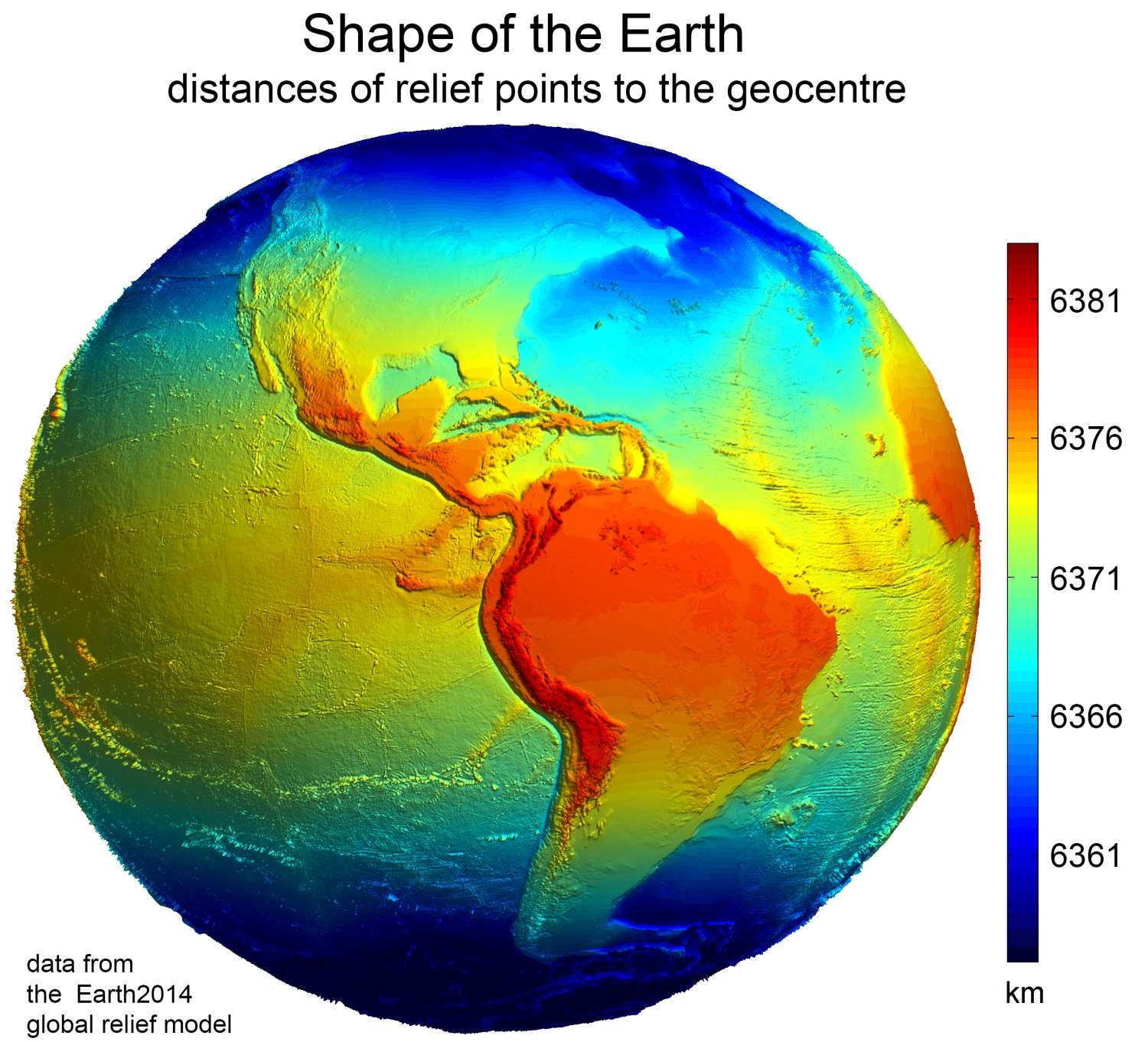
Summary
| DescriptionEarth2014shape SouthAmerica small.jpg |
English: Earth shape, as given by the Earth2014 global relief model. Shown are distances between relief points and the geocentre |
| Date | |
| Source | Own work. |
| Author | Geodesy2000 |
| Other versions | File:Form der Erde.jpg with German lettering made by Sciencia58 |
Licensing
I, the copyright holder of this work, hereby publish it under the following license:
This file is licensed under the Creative Commons Attribution-Share Alike 4.0 International license.
- You are free:
- to share – to copy, distribute and transmit the work
- to remix – to adapt the work
- Under the following conditions:
- attribution – You must give appropriate credit, provide a link to the license, and indicate if changes were made. You may do so in any reasonable manner, but not in any way that suggests the licensor endorses you or your use.
- share alike – If you remix, transform, or build upon the material, you must distribute your contributions under the same or compatible license as the original.
Captions
Add a one-line explanation of what this file represents
Items portrayed in this file
depicts
some value
21 February 2016
image/jpeg
File history
Click on a date/time to view the file as it appeared at that time.
| Date/Time | Thumbnail | Dimensions | User | Comment | |
|---|---|---|---|---|---|
| current | 11:28, 29 November 2022 | | 1,500 × 1,362 (403 KB) | Sciencia58 | Reverted to version as of 22:41, 8 June 2021 (UTC) |
| 07:13, 11 April 2022 |  | 1,600 × 1,400 (593 KB) | CactiStaccingCrane | scaled up font size | |
| 22:41, 8 June 2021 |  | 1,500 × 1,362 (403 KB) | Sciencia58 | so | |
| 16:51, 21 February 2016 |  | 1,500 × 1,362 (195 KB) | Geodesy2000 | Cross-wiki upload from en.wikipedia.org |
File usage
The following pages on the English Wikipedia use this file (pages on other projects are not listed):
Global file usage
The following other wikis use this file:
- Usage on bn.wikipedia.org
- Usage on cs.wikipedia.org
- Usage on en.wikiversity.org
- Usage on es.wikipedia.org
- Usage on eu.wikipedia.org
- Usage on hi.wikipedia.org
- Usage on ja.wikipedia.org
- Usage on mnw.wikipedia.org
- Usage on pt.wikipedia.org
- Usage on ro.wikipedia.org
- Usage on th.wikipedia.org
- Usage on tr.wikipedia.org
- Usage on uk.wikipedia.org
- Usage on zh-yue.wikipedia.org
Metadata
This file contains additional information, probably added from the digital camera or scanner used to create or digitize it.
If the file has been modified from its original state, some details may not fully reflect the modified file.
| Orientation | Normal |
|---|