File:Chicxulub_radar_topography.jpg
From Wikipedia, the free encyclopedia
Size of this preview: 536 × 599 pixels. Other resolutions: 215 × 240 pixels | 429 × 480 pixels | 715 × 799 pixels.
Original file (715 × 799 pixels, file size: 119 KB, MIME type: image/jpeg)
| This is a file from the Wikimedia Commons. Information from its description page there is shown below. Commons is a freely licensed media file repository. You can help. |
Summary
| DescriptionChicxulub radar topography.jpg |
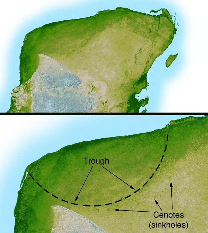
English: This shaded relief image of Mexico's Yucatan Peninsula show a subtle, but unmistakable, indication of the Chicxulub impact crater. Most scientists now agree that this impact was the cause of the Cretatious-Tertiary Extinction, the event approximately 66 million years ago that marked the sudden extinction of the dinosaurs as well as the majority of life then on Earth. |
| Date | |
| Source | http://photojournal.jpl.nasa.gov/catalog/PIA03379 |
| Author | NASA/JPL-Caltech |
| Other versions | version with more labels and scale indicators |
This image or video was catalogued by Jet Propulsion Laboratory of the United States National Aeronautics and Space Administration (NASA) under Photo ID: PIA03379. This tag does not indicate the copyright status of the attached work. A normal copyright tag is still required. See Commons:Licensing. Other languages:
العربية ∙ беларуская (тарашкевіца) ∙ български ∙ català ∙ čeština ∙ dansk ∙ Deutsch ∙ English ∙ español ∙ فارسی ∙ français ∙ galego ∙ magyar ∙ հայերեն ∙ Bahasa Indonesia ∙ italiano ∙ 日本語 ∙ македонски ∙ മലയാളം ∙ Nederlands ∙ polski ∙ português ∙ русский ∙ sicilianu ∙ slovenščina ∙ Türkçe ∙ українська ∙ 简体中文 ∙ 繁體中文 ∙ +/− |
Licensing
| Public domainPublic domainfalsefalse |
| This file is in the public domain in the United States because it was solely created by NASA. NASA copyright policy states that "NASA material is not protected by copyright unless noted". (See Template:PD-USGov, NASA copyright policy page or JPL Image Use Policy.) | ||
 |
Warnings:
|
Captions
Add a one-line explanation of what this file represents
Items portrayed in this file
depicts
February 2000
image/jpeg
ab36347ba3d1d360613733accc555b52ad4ed350
121,839 byte
799 pixel
715 pixel
File history
Click on a date/time to view the file as it appeared at that time.
| Date/Time | Thumbnail | Dimensions | User | Comment | |
|---|---|---|---|---|---|
| current | 04:38, 11 September 2005 | | 715 × 799 (119 KB) | Miya | This image is originally uploaded to English Wikipedia with the informaion as follows: [[{{PD}}Radar topography]] (color corresponds to height) of the [[{{PD}}Yucatán]] peninsula, revealing the en:Chicxulub Crater. Courtesy NASA/JPL-Caltech (it is |
File usage
The following pages on the English Wikipedia use this file (pages on other projects are not listed):
Global file usage
The following other wikis use this file:
- Usage on ar.wikipedia.org
- Usage on ast.wikipedia.org
- Usage on br.wikipedia.org
- Usage on ca.wikipedia.org
- Usage on da.wikipedia.org
- Usage on es.wikipedia.org
- Usage on fr.wikipedia.org
- Usage on hu.wikipedia.org
- Usage on it.wikipedia.org
- Usage on ja.wikipedia.org
- Usage on lt.wikipedia.org
- Usage on lv.wikipedia.org
- Usage on mk.wikipedia.org
- Usage on nl.wikipedia.org
- Usage on oc.wikipedia.org
- Usage on pl.wikipedia.org
- Usage on pt.wikipedia.org
- Usage on su.wikipedia.org
- Usage on te.wikipedia.org
- Usage on vi.wikipedia.org
- Usage on zh.wikipedia.org
Metadata
This file contains additional information, probably added from the digital camera or scanner used to create or digitize it.
If the file has been modified from its original state, some details may not fully reflect the modified file.
| _error | 0 |
|---|
Retrieved from "https://en.wikipedia.org/wiki/File:Chicxulub_radar_topography.jpg"