File:Azuchimomoyama-japan.png
From Wikipedia, the free encyclopedia
Size of this preview: 621 × 600 pixels. Other resolutions: 249 × 240 pixels | 497 × 480 pixels | 795 × 768 pixels | 1,061 × 1,024 pixels | 1,800 × 1,738 pixels.
Original file (1,800 × 1,738 pixels, file size: 978 KB, MIME type: image/png)
| This is a file from the Wikimedia Commons. Information from its description page there is shown below. Commons is a freely licensed media file repository. You can help. |
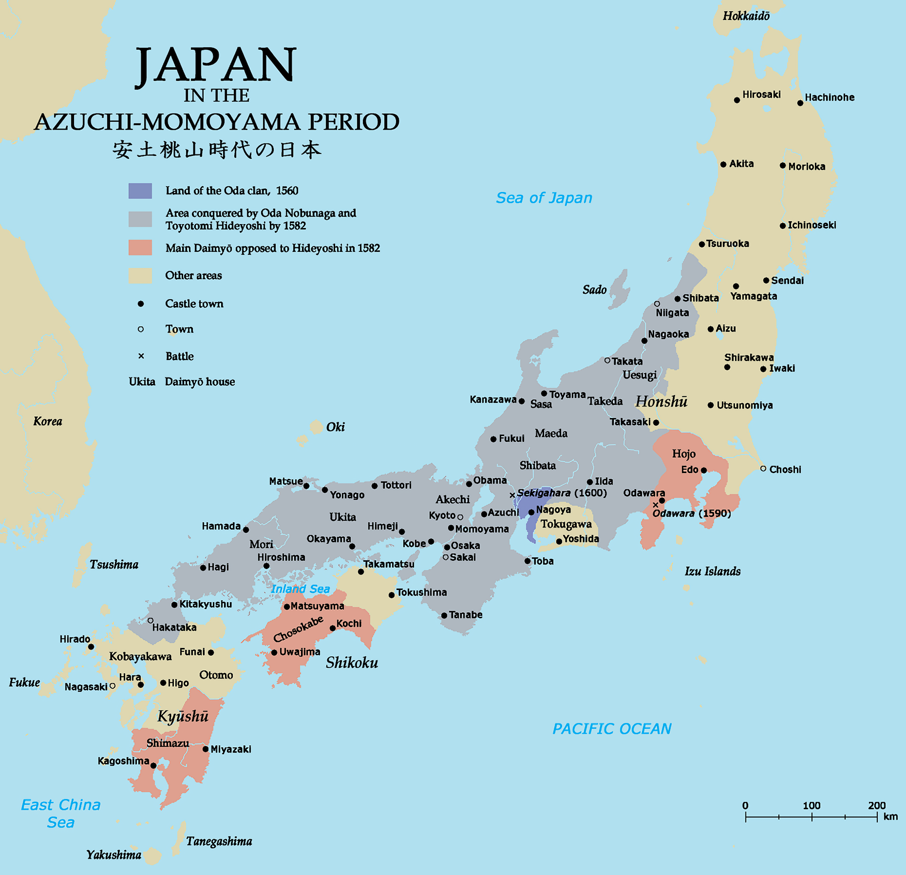
| DescriptionAzuchimomoyama-japan.png | Map of Japan in the Azuchi-Momoyama period. | ||||||||||||||
| Date | |||||||||||||||
| Source | Self-made; base map from Demis MapClip; all information from The Cassell Atlas of World History by John Haywood et al. (Cassell 1997) | ||||||||||||||
| Author | Zakuragi | ||||||||||||||
| Permission (Reusing this file) |
I, the copyright holder of this work, hereby publish it under the following licenses:
This file is licensed under the Creative Commons Attribution-Share Alike 2.5 Generic, 2.0 Generic and 1.0 Generic license.
You may select the license of your choice.
|


|
This historical map image could be re-created using vector graphics as an SVG file. This has several advantages; see Commons:Media for cleanup for more information. If an SVG form of this image is available, please upload it and afterwards replace this template with
{{vector version available|new image name}}.
It is recommended to name the SVG file “Azuchimomoyama-japan.svg”—then the template Vector version available (or Vva) does not need the new image name parameter. |
Captions
Map of Japan in the Azuchi-Momoyama period
Bản đồ Nhật Bản thời An Thổ Đào Sơn (安土桃山時代)
Items portrayed in this file
depicts
9 July 2007
image/png
59fb2b91acafcbc113835487cd779c06f23afc25
1,001,182 byte
1,738 pixel
1,800 pixel
File history
Click on a date/time to view the file as it appeared at that time.
| Date/Time | Thumbnail | Dimensions | User | Comment | |
|---|---|---|---|---|---|
| current | 19:53, 23 August 2022 | | 1,800 × 1,738 (978 KB) | Artanisen | Higher quality version of the map |
| 19:30, 9 July 2007 |  | 930 × 898 (102 KB) | Tonym88~commonswiki | {{Information |Description= Map of Japan in the Azuchi-Momoyama period. |Source= Self-made; base map from [http://www.demis.nl/wms/mapclip.htm Demis MapClip]; all information from ''The Cassell Atlas of World History'' by John Haywood ''et al.'' (Cassell |
File usage
The following pages on the English Wikipedia use this file (pages on other projects are not listed):
Global file usage
The following other wikis use this file:
- Usage on ba.wikipedia.org
- Usage on be.wikipedia.org
- Usage on ca.wikipedia.org
- Usage on cs.wikipedia.org
- Usage on de.wikipedia.org
- Usage on fa.wikipedia.org
- Usage on fr.wikipedia.org
- Usage on glk.wikipedia.org
- Usage on hr.wikipedia.org
- Usage on hu.wikipedia.org
- Usage on id.wikipedia.org
- Usage on it.wikipedia.org
- Usage on nl.wikipedia.org
- Usage on no.wikipedia.org
- Usage on pl.wikipedia.org
- Usage on ro.wikipedia.org
- Usage on ru.wikipedia.org
- Usage on sh.wikipedia.org
- Usage on sk.wikipedia.org
- Usage on sl.wikipedia.org
- Usage on sq.wikipedia.org
- Usage on sr.wikipedia.org
- Usage on th.wikipedia.org
- Usage on tl.wikipedia.org
- Usage on vi.wikipedia.org
- Usage on zh.wikipedia.org
Metadata
This file contains additional information, probably added from the digital camera or scanner used to create or digitize it.
If the file has been modified from its original state, some details may not fully reflect the modified file.
| Horizontal resolution | 72 dpi |
|---|---|
| Vertical resolution | 72 dpi |
| Color space | Uncalibrated |
| Image width | 1,800 px |
| Image height | 1,738 px |
| Software used | Adobe Photoshop CC 2015 (Windows) |
| Date and time of digitizing | 23:45, 23 August 2022 |
| File change date and time | 23:52, 23 August 2022 |
| Date metadata was last modified | 23:52, 23 August 2022 |
| Unique ID of original document | xmp.did:042c19f9-c95f-3a4c-b903-1a101e8ae0db |
Retrieved from "https://en.wikipedia.org/wiki/File:Azuchimomoyama-japan.png"