Loading AI tools

Municipality in Bavaria, Germany From Wikipedia, the free encyclopedia
Etzelwang is a municipality in the district of Amberg-Sulzbach in Bavaria in Germany.
Etzelwang | |
|---|---|
Church of Saint Nicholas | |
 Flag  Coat of arms | |
Location of Etzelwang within Amberg-Sulzbach district 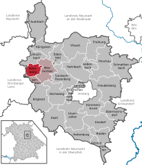 | |
 Etzelwang  Etzelwang | |
| Coordinates: 49°32′N 11°35′E | |
| Country | Germany |
| State | Bavaria |
| Admin. region | Oberpfalz |
| District | Amberg-Sulzbach |
| Municipal assoc. | Neukirchen bei Sulzbach-Rosenberg |
| Government | |
| • Mayor (2020–26) | Roman Berr[1] (CSU) |
| Area | |
| • Total | 21.69 km2 (8.37 sq mi) |
| Highest elevation | 596 m (1,955 ft) |
| Lowest elevation | 390 m (1,280 ft) |
| Population (2023-12-31)[2] | |
| • Total | 1,412 |
| • Density | 65/km2 (170/sq mi) |
| Time zone | UTC+01:00 (CET) |
| • Summer (DST) | UTC+02:00 (CEST) |
| Postal codes | 92268 |
| Dialling codes | 09663 |
| Vehicle registration | AS |
| Website | www.etzelwang.de |
Apart from Etzelwang the municipality consists of the following villages:[3]
Etzelwang has existed as a parish since the second half of the 11th century. However, the present municipality of Etzelwang was not created until the Bavarian administrative reforms of 1972 to 1975. It was created from the political units of Neidstein, Kirchenreinbach, and Schmidtstadt.
Etzel comes from the same root as Heinrich or English Henry. It is not certain which Heinrich gave his name to the parish and subsequently to the municipality. It is possible that it refers to Holy Roman Emperor Heinrich II, who founded the bishopric of Bamberg, to which the parish belonged.[4]
Places of interest in Etzelwang include the following:
Seamless Wikipedia browsing. On steroids.
Every time you click a link to Wikipedia, Wiktionary or Wikiquote in your browser's search results, it will show the modern Wikiwand interface.
Wikiwand extension is a five stars, simple, with minimum permission required to keep your browsing private, safe and transparent.