Elsterwerda
Town in Brandenburg, Germany From Wikipedia, the free encyclopedia
Town in Brandenburg, Germany From Wikipedia, the free encyclopedia
Elsterwerda (German pronunciation: [ˌɛlstɐˈvɛʁda] ; Lower Sorbian: Wikow) is a town in the Elbe-Elster district, in southwestern Brandenburg, Germany. It is situated on the Black Elster river, 48 km northwest of Dresden, and 11 km southeast of Bad Liebenwerda.
You can help expand this article with text translated from the corresponding article in German. (December 2009) Click [show] for important translation instructions.
|
Elsterwerda | |
|---|---|
 Château | |
 Coat of arms | |
Location of Elsterwerda within Elbe-Elster district  | |
 Elsterwerda  Elsterwerda | |
| Coordinates: 51°27′28″N 13°31′26″E | |
| Country | Germany |
| State | Brandenburg |
| District | Elbe-Elster |
| Subdivisions | Town centre and 2 districts |
| Government | |
| • Mayor (2017–25) | Anja Heinrich[1] (CDU) |
| Area | |
| • Total | 40.55 km2 (15.66 sq mi) |
| Elevation | 90 m (300 ft) |
| Population (2022-12-31)[2] | |
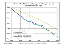
| • Total | 7,792 |
| • Density | 190/km2 (500/sq mi) |
| Time zone | UTC+01:00 (CET) |
| • Summer (DST) | UTC+02:00 (CEST) |
| Postal codes | 04910 |
| Dialling codes | 03533 |
| Vehicle registration | EE, FI, LIB |
| Website | www.elsterwerda.de |
From 1952 to 1990, Elsterwerda was part of the Bezirk Cottbus of East Germany.

|
|
|


Seamless Wikipedia browsing. On steroids.
Every time you click a link to Wikipedia, Wiktionary or Wikiquote in your browser's search results, it will show the modern Wikiwand interface.
Wikiwand extension is a five stars, simple, with minimum permission required to keep your browsing private, safe and transparent.
