
Electoral district of Burnett
State electoral district of Queensland, Australia / From Wikipedia, the free encyclopedia
Dear Wikiwand AI, let's keep it short by simply answering these key questions:
Can you list the top facts and stats about Electoral district of Burnett?
Summarize this article for a 10 year old
SHOW ALL QUESTIONS
For the former New South Wales state electorate, see Electoral district of Burnett (New South Wales).
Burnett is an electoral division of the Legislative Assembly of Queensland in central Queensland, Australia.[1]
Quick Facts Burnett Queensland—Legislative Assembly, State ...
| Burnett Queensland—Legislative Assembly | |||||||||||||||
|---|---|---|---|---|---|---|---|---|---|---|---|---|---|---|---|
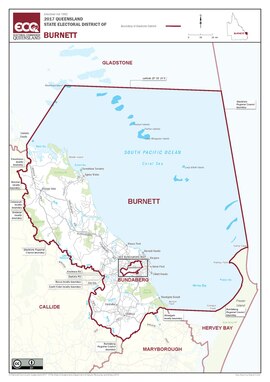 Map of the electoral district of Burnett, 2017 | |||||||||||||||
| State | Queensland | ||||||||||||||
| MP | Stephen Bennett | ||||||||||||||
| Party | Liberal National | ||||||||||||||
| Namesake | Burnett River | ||||||||||||||
| Electors | 35,928 (2020) | ||||||||||||||
| Area | 7,687 km2 (2,968.0 sq mi) | ||||||||||||||
| Demographic | Rural | ||||||||||||||
| Coordinates | 24°37′S 152°2′E | ||||||||||||||
| |||||||||||||||
Close

It covers most of the coastal region south of Gladstone, as well as coastal and inland regions completely surrounding the district of Bundaberg. Towns within its boundaries include Miriam Vale, Agnes Water, Rosedale, Bargara, Woodgate and Childers. The Burnett River flows through the electoral district, hence its name.