
Dora, Alabama
City in Alabama, United States / From Wikipedia, the free encyclopedia
Dear Wikiwand AI, let's keep it short by simply answering these key questions:
Can you list the top facts and stats about Dora, Alabama?
Summarize this article for a 10 year old
SHOW ALL QUESTIONS
Dora is a city in Walker County, Alabama, United States. Coal mining took place in the area.
Quick Facts Country, State ...
Dora, Alabama | |
|---|---|
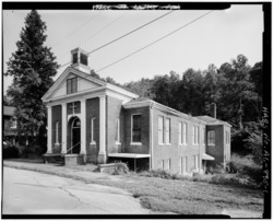 Old Methodist Church, taken as part of the Historic American Buildings Survey | |
 Location of Dora in Walker County, Alabama. | |
| Coordinates: 33°43′45″N 87°5′25″W | |
| Country | United States |
| State | Alabama |
| County | Walker |
| Government | |
| • Mayor | Hezekiah Walker |
| Area | |
| • Total | 7.92 sq mi (20.51 km2) |
| • Land | 7.91 sq mi (20.49 km2) |
| • Water | 0.01 sq mi (0.03 km2) |
| Elevation | 394 ft (120 m) |
| Population (2020) | |
| • Total | 2,297 |
| • Density | 290.43/sq mi (112.13/km2) |
| Time zone | UTC-6 (Central (CST)) |
| • Summer (DST) | UTC-5 (CDT) |
| ZIP code | 35062[2] |
| Area code(s) | 205 and 659 |
| FIPS code | 01-21136 |
| GNIS feature ID | 0155055 |
| Website | www.cityofdora.com |
Close