Dix Hills, New York
Hamlet and census-designated place in New York, United States From Wikipedia, the free encyclopedia
Hamlet and census-designated place in New York, United States From Wikipedia, the free encyclopedia
Dix Hills is an affluent hamlet[3] and census-designated place (CDP), in the town of Huntington, New York. The population was 26,180 at the 2020 census.
This article needs additional citations for verification. (February 2013) |
Dix Hills, New York | |
|---|---|
 Half Hollow Hills Community Library in Dix Hills, New York | |
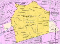
 U.S. Census map | |
| Coordinates: 40°47′46″N 73°20′4″W | |
| Country | |
| State | |
| County | Suffolk |
| Area | |
| • Total | 15.75 sq mi (40.79 km2) |
| • Land | 15.75 sq mi (40.79 km2) |
| • Water | 0.00 sq mi (0.00 km2) |
| Elevation | 203 ft (62 m) |
| Population | |
| • Total | 26,180 |
| • Density | 1,662.33/sq mi (641.81/km2) |
| Time zone | UTC-5 (Eastern (EST)) |
| • Summer (DST) | UTC-4 (EDT) |
| ZIP code | 11746 |
| Area code(s) | 631, 934 |
| FIPS code | 36-20687 |
| GNIS feature ID | 1867400 |
Settlers traded goods with the Indigenous Secatogue tribe for the land that became Dix Hills in 1699. The Secatogues lived in the northern portion of the region during the later half of that century. The land was known as Dick's Hills. By lore, the name traces to a local native named Dick Pechegan, likely of the Secatogues.[4][note 1] Scholar William Wallace Tooker wrote that the addition of the English name "Dick" to the indigenous name "Pechegan" was a common practice.
Tooker wrote that Pechegan's wigwam and his planted fields became the hilly area's namesake, known as the shortened "Dix Hills" by 1911.[5] The area was mostly used for farming until after World War II.[4]
In the 1950s, Dix Hills and its neighbors Wheatley Heights and Melville, along with the area known as Sweet Hollow, proposed to incorporate as a single village.[6][7] This village would have been known as the Incorporated Village of Half Hollow Hills, would have had an area of roughly 50 square miles (130 km2), and would have embraced the Half Hollow Hills Central School District (CSD 5).[6] The plans were unsuccessful, and these areas would remain unincorporated.[8]
Proposals were revived around 2001, when Dix Hills, Melville, Wheatley Heights, and East Farmingdale (all within the school district) proposed incorporating as a single village.[9] These plans also failed and each remains unincorporated hamlets to this day.[8]
According to the United States Census Bureau, the CDP of Dix Hills has a total area of 15.9 square miles (41.3 km2), all of it land.[10] The town of Huntington, of which Dix Hills is a part, has a total area of 137.1 square miles (355.1 km2), of which 94.1 square miles (243.8 km2) is land and 43.0 square miles (111.3 km2), or 31.35%, is water.[11]
Dix Hills is located centrally on Long Island, on the southern edge of Huntington, bordering the town of Babylon.[8]
The Long Island Expressway passes almost straight through the middle of the hamlet.[8]
As of the 2020 U.S. Census,[2] there were 26,180 people, 7,765 households residing in Dix Hills. The population density was 1,662.3 per square mile. The racial makeup of Dix Hills was 74.7% White, 15.1% Asian, 6.1% are Hispanic or Latino of any race, 3.7% African American, 0.8% Native American, 0.0% Pacific Islander, and 4.8% from two or more races. Dix Hills, like many other towns on the North Shore of Long Island, has a large Jewish population, as well as a large number of residents of Asian origin. 25.6% of the population spoke a language other than English at home, mostly Chinese or Korean.
The median household income (in 2021 dollars) in Dix Hills was $184,580.[2] The per capita income for Dix Hills was $75,486. About 4.9% of the population was below the poverty line.[2]
Dix Hills had Long Island's highest number of electric vehicles on the road by ZIP Code as of 2023.[12]
Dix Hills is served by the Half Hollow Hills Central School District and the Commack School District.[8] The Half Hollow Hills elementary schools are Otsego, Paumanok, Signal Hill, Sunquam, and Vanderbilt.[8]
Middle schools that serve the district are Candlewood Middle School and West Hollow Middle School.[8] The high schools are Half Hollow Hills High School East and Half Hollow Hills High School West.[8] Commack Middle School and Rolling Hills Elementary are both a part of the Commack School District and are located within Dix Hills.[8]
Five Towns College is also located within Dix Hills.[citation needed]
Dix Hills is part of the Half Hollow Hills Community Library.[13]
This section needs additional citations for verification. (October 2012) |
Dix Hills is served by the Dix Hills Fire Department,[14] through three stations. The Dix Hills Fire Department's headquarters (Company 2) is located on Deer Park Avenue, immediately north of the Northern State Parkway. Substation #1 (Company 3) is located on Deer Park Avenue, south of the Long Island Expressway.
Substation #2 (Company 1) is located on Carll's Straight Path, about half of a mile south of the Long Island Expressway. The Dix Hills Fire Department consists of approximately 150 volunteer firefighters and emergency medical technicians who respond to over 2,500 calls for assistance each year – ranging from fires to motor vehicle accidents to medical and traumatic emergencies.
Seamless Wikipedia browsing. On steroids.
Every time you click a link to Wikipedia, Wiktionary or Wikiquote in your browser's search results, it will show the modern Wikiwand interface.
Wikiwand extension is a five stars, simple, with minimum permission required to keep your browsing private, safe and transparent.