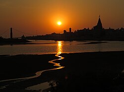
Devbhumi Dwarka district
District of Gujarat in India From Wikipedia, the free encyclopedia
Devbhumi Dwarka District is a district of India located on the southern coast of the Gulf of Kutch in the state of Gujarat. Its headquarters are located in the city of Jamkhambhaliya. The district was created on 15 August 2013 from Jamnagar district.[1][2][3]
Devbhumi Dwarka district | |
|---|---|
 | |
 Location in Gujarat | |
| Coordinates: 22°12′N 69°39′E | |
| Country | India |
| State | Gujarat |
| Region | Saurashtra |
| Headquarters | Jamkhambhaliya |
| Area | |
• Total | 4,051 km2 (1,564 sq mi) |
| Population (2011) | |
• Total | 752,484 |
| • Density | 190/km2 (480/sq mi) |
| Languages | |
| • Official | Gujarati, Hindi |
| Time zone | UTC+5:30 (IST) |
| Vehicle registration | GJ-37 |
| Website | Official Website of Devbhumi Dwarka District |
Talukas (Administrative Divisions)
The district consists of 4 talukas:
Demographics
The divided district had a population of 752,484, of which 241,795 (32.13%) lived in urban areas. The residual district had a sex ratio of 947 females per 1000 males. Scheduled Castes and Scheduled Tribes made up 50,937 (6.77%) and 9,687 (1.29%) of the population respectively.[4]
Religion
Hindus were 636,991 (84.65%) while Muslims were 112,894 (15.00%).[5]
Language
At the time of the 2011 census, 88.12% of the population spoke Gujarati, 9.35% Kachchhi and 1.63% Hindi as their first language.[6]
Politics
| District | No. | Constituency | Name | Party | Remarks | |
|---|---|---|---|---|---|---|
| Devbhoomi Dwarka | 81 | Khambhaliya | Mulubhai Bera | Bharatiya Janata Party | MoS | |
| 82 | Dwarka | Pabubha Manek | Bharatiya Janata Party | |||
Villages
References
External links
Wikiwand - on
Seamless Wikipedia browsing. On steroids.

