Loading AI tools
Municipality in North, Brazil From Wikipedia, the free encyclopedia
Coari (Choary) is a municipality located in the Brazilian state of Amazonas.
Coari | |
|---|---|
 | |
| Nickname: "Solimões Queen"
"Gas City" | |
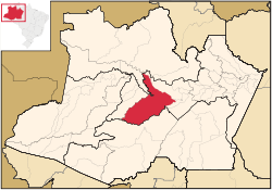
 Coari municipality (red) in Amazonas state | |
| Coordinates: 04°05′06″S 63°08′27″W | |
| Country | |
| Region | North |
| State | |
| Government | |
| • Mayor | Manoel Adail Amaral Pinheiro (PRP) |
| Area | |
| • Municipality | 57,921.646 km2 (22,363.673 sq mi) |
| Elevation | 40 m (120 ft) |
| Population (2020[1]) | |
| • Metro | 85,910 |
| Time zone | UTC−4 (AMT) |
| ZIP code | 69460-000 |
| Climate | Af |
| Website | www |
The municipal seat of Coari is one of the largest cities of the Amazonas state. It is the seat of the Roman Catholic Diocese of Coari. The area has reserves of oil and natural gas. Coari is served by Coari Airport located 6 km from downtown Coari. Porto Urucu Airport located in the district of Porto Urucu 470 km away serves the population residing and working for Petrobras.
The municipality is in the Juruá-Purus moist forests ecoregion.[2] It contains part of the Amanã Sustainable Development Reserve.[3] It contains a small portion of the 1,008,167 hectares (2,491,230 acres) Piagaçu-Purus Sustainable Development Reserve, established in 2003.[4] The municipality contains 66.15% of the 217,486 hectares (537,420 acres) Catuá-Ipixuna Extractive Reserve, established in 2003 as the first extractive reserve in the state of Amazonas.[5]
| Climate data for Coari (1981–2010, extremes 1961–present) | |||||||||||||
|---|---|---|---|---|---|---|---|---|---|---|---|---|---|
| Month | Jan | Feb | Mar | Apr | May | Jun | Jul | Aug | Sep | Oct | Nov | Dec | Year |
| Record high °C (°F) | 36.9 (98.4) |
36.6 (97.9) |
36.4 (97.5) |
36.4 (97.5) |
36.0 (96.8) |
38.0 (100.4) |
39.8 (103.6) |
37.5 (99.5) |
38.3 (100.9) |
38.2 (100.8) |
38.3 (100.9) |
38.2 (100.8) |
39.8 (103.6) |
| Mean daily maximum °C (°F) | 31.8 (89.2) |
31.9 (89.4) |
32.0 (89.6) |
31.9 (89.4) |
31.7 (89.1) |
31.7 (89.1) |
32.2 (90.0) |
33.2 (91.8) |
33.3 (91.9) |
33.2 (91.8) |
32.6 (90.7) |
32.1 (89.8) |
32.3 (90.1) |
| Daily mean °C (°F) | 26.4 (79.5) |
26.4 (79.5) |
26.6 (79.9) |
26.6 (79.9) |
26.6 (79.9) |
26.4 (79.5) |
26.8 (80.2) |
27.4 (81.3) |
27.4 (81.3) |
27.3 (81.1) |
27.0 (80.6) |
26.8 (80.2) |
26.8 (80.2) |
| Mean daily minimum °C (°F) | 21.6 (70.9) |
21.8 (71.2) |
22.0 (71.6) |
22.0 (71.6) |
22.1 (71.8) |
21.9 (71.4) |
21.9 (71.4) |
22.2 (72.0) |
22.3 (72.1) |
22.4 (72.3) |
22.4 (72.3) |
22.2 (72.0) |
22.1 (71.8) |
| Record low °C (°F) | 14.6 (58.3) |
15.4 (59.7) |
10.6 (51.1) |
15.6 (60.1) |
14.0 (57.2) |
10.2 (50.4) |
11.0 (51.8) |
14.8 (58.6) |
15.0 (59.0) |
15.7 (60.3) |
16.4 (61.5) |
15.2 (59.4) |
10.2 (50.4) |
| Average precipitation mm (inches) | 264.5 (10.41) |
265.5 (10.45) |
322.3 (12.69) |
272.4 (10.72) |
213.1 (8.39) |
128.9 (5.07) |
87.2 (3.43) |
68.9 (2.71) |
100.4 (3.95) |
156.7 (6.17) |
215.6 (8.49) |
261.7 (10.30) |
2,357.2 (92.80) |
| Average precipitation days (≥ 1.0 mm) | 18 | 17 | 18 | 17 | 16 | 13 | 9 | 8 | 9 | 12 | 13 | 16 | 166 |
| Average relative humidity (%) | 85.6 | 84.9 | 84.9 | 85.0 | 85.1 | 83.9 | 80.8 | 78.1 | 78.8 | 79.7 | 81.9 | 83.6 | 82.7 |
| Mean monthly sunshine hours | 138.2 | 120.2 | 122.0 | 132.5 | 152.5 | 171.2 | 207.1 | 208.8 | 180.4 | 171.7 | 141.1 | 143.1 | 1,888.8 |
| Source 1: Instituto Nacional de Meteorologia[6] | |||||||||||||
| Source 2: Meteo Climat (record highs and lows)[7] | |||||||||||||
Seamless Wikipedia browsing. On steroids.
Every time you click a link to Wikipedia, Wiktionary or Wikiquote in your browser's search results, it will show the modern Wikiwand interface.
Wikiwand extension is a five stars, simple, with minimum permission required to keep your browsing private, safe and transparent.