
Cherbourg, Queensland
Town in Queensland, Australia / From Wikipedia, the free encyclopedia
Dear Wikiwand AI, let's keep it short by simply answering these key questions:
Can you list the top facts and stats about Cherbourg, Queensland?
Summarize this article for a 10 year old
SHOW ALL QUESTIONS
Cherbourg (/ˈʃɜːbɜːɡ/[2]), formerly known as Barambah, Barambah Aboriginal Settlement and Cherbourg Aboriginal Settlement, is a rural town and locality in the Aboriginal Shire of Cherbourg, Queensland, Australia.[3][4]
Map all coordinates using OpenStreetMap
Download coordinates as:
Quick Facts Cherbourg Queensland, Coordinates ...
| Cherbourg Queensland | |||||||||||||||
|---|---|---|---|---|---|---|---|---|---|---|---|---|---|---|---|
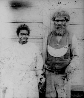 George of Saxby Downs with his wife at Barambah Aboriginal Settlement, 1909 | |||||||||||||||
 Cherbourg | |||||||||||||||
| Coordinates | 26.2920°S 151.9543°E / -26.2920; 151.9543 (Cherbourg (town centre)) | ||||||||||||||
| Population | 1,194 (2021 census)[1] | ||||||||||||||
| • Density | 37.55/km2 (97.25/sq mi) | ||||||||||||||
| Established | 1900 | ||||||||||||||
| Postcode(s) | 4605 | ||||||||||||||
| Elevation | 310 m (1,017 ft) | ||||||||||||||
| Area | 31.8 km2 (12.3 sq mi) | ||||||||||||||
| Time zone | AEST (UTC+10:00) | ||||||||||||||
| Location | |||||||||||||||
| LGA(s) | Aboriginal Shire of Cherbourg | ||||||||||||||
| State electorate(s) | Nanango | ||||||||||||||
| Federal division(s) | Wide Bay | ||||||||||||||
| |||||||||||||||
Close
In the 2021 census, the locality of Cherbourg had a population of 1,194 people, of whom 1,151 (96.4%) identified as Indigenous Australians.[1]