Loading AI tools

Place in Khyber Pakhtunkhwa, Pakistan From Wikipedia, the free encyclopedia
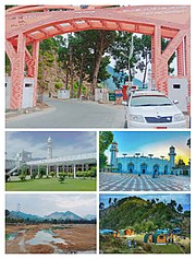
Charbagh (Pashto: چارباغ) is a town in Tehsil Charbagh, in the Khyber Pakhtunkhwa province of Pakistan. It is part of Swat District and is located at 34°50'0"N 72°26'30"E with an average altitude of 1,032 meters (3,386 feet).[2] It is located on the N-95 National Highway some 15 km from mingora in Khyber Pakhtunkhwa.
Charbagh | |
|---|---|
 Charbagh | |
| Coordinates: 34.50°N 72.26°E | |
| Country | |
| Province | Khyber Pakhtunkhwa |
| Elevation | 980 m (3,220 ft) |
| Population | |
| • Total | 39,605 |
| Time zone | UTC+5 (PST) |


Tehsil Charbagh is also known as Matorizi Tehsil and it borders with Babuzai tehsil and Azikhel Tehsil. Some of the villages included in Tehsil Charbagh are:
The University of Swat is 800 meters away from Charbagh bazaar situated in Allahabad, Cadet College Swat, a premier educational institution of the province, is in Gulibagh and also the Private University Town are in this Tehsil.
The population of Charbagh is 39,605.[3] According to the 2017 census the population of tehsil Charbagh is 126,115.[4][3] Charbagh tehsil has a population density of 934.9/km2 .[4]