Loading AI tools
Chandina Upazila
Upazila in Chittagong, Bangladesh From Wikipedia, the free encyclopedia
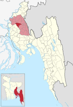
Chandina (Bengali: চান্দিনা) is an upazila of Comilla District in the Division of Chittagong, Bangladesh.[4]
Chandina
চান্দিনা | |
|---|---|
 Three-domed Jame Masjid | |
 | |
| Coordinates: 23°29′N 91°0.5′E | |
| Country | |
| Division | Chittagong |
| District | Comilla |
| Area | |
| • Total | 201.01 km2 (77.61 sq mi) |
| Population | |
| • Total | 394,874 |
| • Density | 2,000/km2 (5,100/sq mi) |
| Time zone | UTC+6 (BST) |
| Postal code | 3510[2] |
| Area code | 08022[3] |
| Website | chandina |
Chandina is located at 23.4833°N 91.0083°E. It has 69,736 households and a total area of 201.01 km2. Chandina township is a class B municipality, which is located at the extreme north of the upazila by the N1 or Dhaka-Chittagong Highway. Value of property in the Municipality have increased significantly in last decade due to its proximity to N1 and heavy influx of people coming from villages for education & jobs.
According to the 2011 Census of Bangladesh, Chandina Upazila had 69,736 households and a population of 350,273. 92,365 (26.37%) were under 10 years of age. Chandina had a literacy rate (age 7 and over) of 51.01%, compared to the national average of 51.8%, and a sex ratio of 1112 females per 1000 males. 48,471 (13.84%) lived in urban areas.[5][6]
Chandina Upazila is divided into Chandina Municipality and 13 union parishads. They are Barera, Batagashi, Borkoroi, Barkait, Dollai Nawabpur, Etberpur, Gollai, Joag, Keronkhal, Madhaiya, Maijkhar, Mohichail, and Shuhilpur alphabetically. 13 Union parishads are further subdivided into 121 mauzas and 223 villages.[5]
Chandina Municipality is subdivided into 9 wards and 19 mahallas.[5]
Seamless Wikipedia browsing. On steroids.
Every time you click a link to Wikipedia, Wiktionary or Wikiquote in your browser's search results, it will show the modern Wikiwand interface.
Wikiwand extension is a five stars, simple, with minimum permission required to keep your browsing private, safe and transparent.