Chandanaish Upazila
Upazila in Chattogram Division, Bangladesh From Wikipedia, the free encyclopedia
Upazila in Chattogram Division, Bangladesh From Wikipedia, the free encyclopedia
Chandanaish (Bengali: চন্দনাইশ) is an upazila of Chattogram District[4] in Chattogram Division, Bangladesh.
Chandanaish
চন্দনাইশ | |
|---|---|
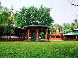
 Central Tapoban Ashram, Dohazari | |
 | |
| Coordinates: 22°12.7′N 92°2.5′E | |
| Country | |
| Division | Chittagong |
| District | Chittagong |
| Jatiya Sangsad constituency | Chittagong-14 |
| Headquarters | Chandanaish Upazila Complex |
| Government | |
| • Body | Upazila Council |
| • MP | Vacant |
| • Chairman | Kamela Khanam (Acting) |
| Area | |
| • Total | 201.99 km2 (77.99 sq mi) |
| Population | |
| • Total | 252,242 |
| • Density | 1,200/km2 (3,200/sq mi) |
| Time zone | UTC+6 (BST) |
| Postal code | 4380[2] |
| Area code | 03033[3] |
| Website | chandanaish.gov.bd |
Chandanaish is one of the first inhabitant of the early settlers of Chittagong. Muslim traders and preachers from the then Islamic worlds had been settling in Chandanaish due to the close proximity of Chandanaish from the river Karnaphuli. However, the Muslim settlement was permanently established when the medieval Islamic invasion occurred in Chittagong.
Chandanaish was previously part of Patiya upazila. In 1976, Chandanaish was separated from Patiya and established as Chandanaish thana and in 1983 it became an upazila.
Chandanaish is located at 22.2111°N 92.0417°E. It has 44,438 households and a total area of 201.99 km2. Its west side is plainland and its east side is surrounded with the tertiary hill tracts. Here cultivable land is very fertile. Sangu is the main river but there are also small rivers and canals like Borumoti (Borguni Khal locally called), Chandkhali river etc. There are a lot of Beels such as Moga Beel, Arah Beel, Ronger Beel.
As of the 2011 Census of Bangladesh, Chandanaish upazila had 44,438 households and a population of 233,017. 55,629 (23.87%) were under 10 years of age. Chandanaish had an average literacy rate of 53.61%, compared to the national average of 51.8%, and a sex ratio of 985 females per 1000 males. 35,248 (15.13%) of the population lived in urban areas.[6] Ethnic population was 968 (0.42%) of the population.[7]
According to the 1991 Bangladesh census, Chandanaish had a population of 172,843. Males constituted 51.27% of the population, and females 48.73%. The population aged 18 or over was 81,653. Chandanaish had an average literacy rate of 33.9% (7+ years), compared to the national average of 32.4%.[8]
Chandanaish Upazila is divided into Chandanaish Municipality, Dohazari Municipality, and nine union parishads: Bailtali, Barama, Barkal, Dhopachhari, Dohazari, Hashimpur, Joara, Kanchanabad, and Satbaria. The union parishads are subdivided into 44 mauzas and 46 villages.[9][10]
Chandanaish Municipality is subdivided into 9 wards and 12 mahallas.[9]
MP: Vacant
Upazila Chairman: Vacant Vice Chairman: Vacant
Female V. Chairman: Vacant
Chandnaish upazila has 2 hospitals, 2 upazila health complexes, 5 union health centers, 10 family planning centers and 10 community clinics.[11]
The main communication road in Chandanish Upazila is Chittagong-Cox's Bazar highway. This upazila can be contacted over Barkal Bridge of Chittagong-Anwara District. Can be contacted by various types of vehicles. In addition, this upazila has 91 kilometres (57 mi) of paved roads, 450 kilometres (280 mi) of semi-pacara roads, 700 kilometres (430 mi) of unpaved roads. This upazila also has rail communication system. There is also a communication system with other upazilas through Sangu river.[11]
Universities
Medical colleges
Colleges
High schools
Madrasahs
Others
Seamless Wikipedia browsing. On steroids.
Every time you click a link to Wikipedia, Wiktionary or Wikiquote in your browser's search results, it will show the modern Wikiwand interface.
Wikiwand extension is a five stars, simple, with minimum permission required to keep your browsing private, safe and transparent.