Loading AI tools
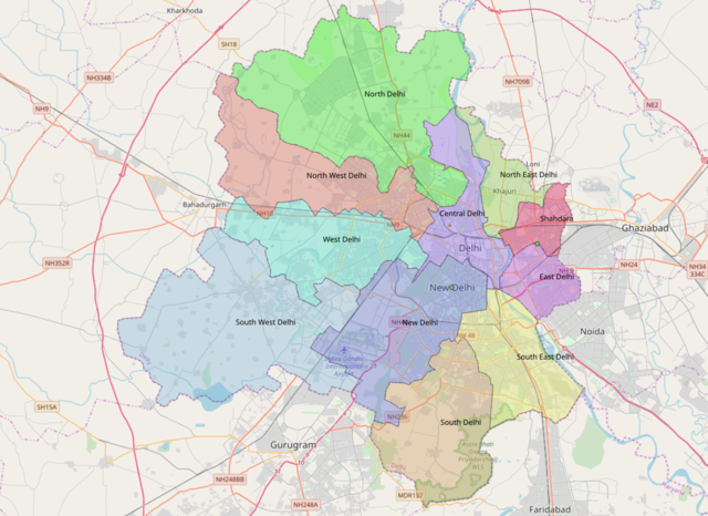
Central Delhi is an administrative district of the National Capital Territory of Delhi in India. It is bounded by the Yamuna River on the east and by the districts of North Delhi to the north, West Delhi and South West Delhi to the west, New Delhi to the south, and East Delhi to the east across the Yamuna.
Central Delhi | |
|---|---|
| Coordinates: 28°38′42″N 77°14′42″E | |
| Country | |
| Union territory | Delhi |
| Division | Delhi division |
| Headquarters | Daryaganj |
| Government | |
| • District Magistrate | G Sudhakar, IAS[1] |
| Population (2011) | |
| • Total | 582,320 |
| Languages | |
| • Official | Hindi, English, Punjabi, Urdu |
| Time zone | UTC+5:30 (IST) |
| PIN | 1100xx[2] |
| Lok Sabha MP | Praveen Khandelwal |
| Deputy Commissioner | Arun Kumar Mishra |
| Website | dccentral |
Central Delhi has a population of 582,320 (2011 census), and an area of 25 square kilometres (9.7 sq mi), with a population density of 25,759/km2 (66,720/sq mi). Central Delhi business district and high rises. It includes Old Delhi.
The Central District is headed by a District Magistrate under whom there is an Additional District Magistrate, three Sub-Divisional Magistrates, three Tehsildars and two Sub-Registrar Officers. The District Magistrate reports to Divisional Commissioner. DM is the monitoring/control officer who supervises and directs the work.[3][4]
The district is divided into three subdivisions, Civil Lines, Karol Bagh, and Kotwali, Delhi.

Each Subdivision is headed by a SDM and has police stations under it.[3]
SDM Kotwali 1) Darya Ganj 2) Jama Masjid 3) Chandni Mahal 4) I P Estate 5) Sarai Rohilla 6) Gulabi Bagh 7) Sadar Bazar 8) Bada Hindu Rao 9) Sabzi Mandi 10) Kotwali 11) Lahori Gate 12) Kashmiri Gate 13) Old Delhi Railway Station 14) Kashmiri Gate Metro Station 15) Sarai Rohilla Railway Station
SDM Karol Bagh 1) Karol Bagh 2) Rajinder Nagar 3) Prasad Nagar 4) Deshbandhu Gupta Road 5) Pahar Ganj 6) Nabi Karim 7) Kamla Market 8) Hauz Qazi
SDM Civil Lines 1) Civil Lines 2) Roop Nagar 3) Burari 4) Timar Pur 5) Maurice Nagar
| Year | Pop. | ±% p.a. |
|---|---|---|
| 1961 | 672,063 | — |
| 1971 | 691,738 | +0.29% |
| 1981 | 691,223 | −0.01% |
| 1991 | 656,533 | −0.51% |
| 2001 | 646,385 | −0.16% |
| 2011 | 582,320 | −1.04% |
| Source:[5] | ||
According to the 2011 census Central Delhi has a population of 582,320,[6] roughly equal to the nation of Solomon Islands[7] or the US state of Wyoming.[8] This gives it a ranking of 531st in India (out of a total of 640).[6] The district has a population density of 23,149 inhabitants per square kilometre (59,960/sq mi).[6] Its population growth rate over the decade 2001–2011 was −10.48%.[6] Central Delhi has a sex ratio of 892 females for every 1000 males,[6] and a literacy rate of 85.25%.[6]
The readjusted Central Delhi district has a population of 894,389, of which 876,643 (98.02%) live in urban areas. The readjusted district has a sex ratio of 876 females per 1000 males. Scheduled Castes make up 197,123 (22.04%) of the population.[6]
At the time of the 2011 census, 85.05% of the population spoke Hindi, 4.27% Punjabi, 3.59% Urdu, 1.16% Bhojpuri and 1.05% Bengali as their first language.[10]
Wikiwand in your browser!
Seamless Wikipedia browsing. On steroids.
Every time you click a link to Wikipedia, Wiktionary or Wikiquote in your browser's search results, it will show the modern Wikiwand interface.
Wikiwand extension is a five stars, simple, with minimum permission required to keep your browsing private, safe and transparent.
