Loading AI tools
Barrio of Puerto Rico From Wikipedia, the free encyclopedia
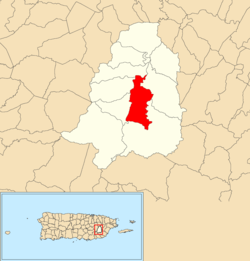
Cayaguas is a barrio in the municipality of San Lorenzo, Puerto Rico. Its population in 2010 was 1,682.[3][4][5]
Cayaguas | |
|---|---|
Barrio | |
 Location of Cayaguas within the municipality of San Lorenzo shown in red | |
| Coordinates: 18°08′40″N 65°58′20″W[1] | |
| Commonwealth | |
| Municipality | |
| Area | |
| • Total | 3.96 sq mi (10.3 km2) |
| • Land | 3.96 sq mi (10.3 km2) |
| • Water | 0 sq mi (0 km2) |
| Elevation | 627 ft (191 m) |
| Population (2010) | |
| • Total | 1,682 |
| • Density | 425.8/sq mi (164.4/km2) |
| Source: 2010 Census | |
| Time zone | UTC−4 (AST) |
Barrios (which are, in contemporary times, roughly comparable to minor civil divisions)[11] in turn are further subdivided into smaller local populated place areas/units called sectores (sectors in English). The types of sectores may vary, from normally sector to urbanización to reparto to barriada to residencial, among others.[12][13][14]
The following sectors are in Cayaguas barrio:[15][16]
Camino Carlos Colón, Camino Esperanza Roldán, Camino Gamalier, Camino Los Rivera, Camino Rivera, Sector Alverio, Sector Capilla, Sector Dávila, Sector La Represa, Sector Los Grillos, Sector Manchurria, Sector Morales, Sector Pablo Muñoz, Sector Piedras Blancas, Sector Rivera, Sector Robles, and Sector Teyo Rodríguez.
Seamless Wikipedia browsing. On steroids.
Every time you click a link to Wikipedia, Wiktionary or Wikiquote in your browser's search results, it will show the modern Wikiwand interface.
Wikiwand extension is a five stars, simple, with minimum permission required to keep your browsing private, safe and transparent.