Broadway (Los Angeles)
Major thoroughfare in Los Angeles County, California, USA From Wikipedia, the free encyclopedia

Broadway, until 1890 Fort Street, is a major thoroughfare in Los Angeles County, California, United States. The portion of Broadway from 3rd to 9th streets, in the Historic Core of Downtown Los Angeles, was the city's main commercial street from the 1910s until World War II, and is the location of the Broadway Theater and Commercial District, the first and largest historic theater district listed on the National Register of Historic Places (NRHP).[2] With twelve movie palaces located along a six-block stretch, it is the only large concentration of movie palaces left in the United States.
Broadway Theater and Commercial District (NRHP) Broadway Theater and Entertainment District (City of Los Angeles) | |
,_September_2020.jpg) Broadway looking north towards the historic Theater and Commercial District from Hoxton Hotel Roof (11th St.), September 2020 | |
 | |
| Location | 300—849 S. Broadway Los Angeles, California |
|---|---|
| Coordinates | 34°2′48″N 118°15′4″W |
| Architect | Multiple |
| Architectural style | Early Commercial, Late 19th And 20th Century Revivals, Art Deco |
| NRHP reference No. | 79000484 [1] |
| Added to NRHP | May 9, 1979 |
 Los Angeles Theatre | |
| Maintained by | |
|---|---|
| Length | 17.75 mi (28.57 km) |
| Location | Los Angeles |
| South end | Main Street in Carson |
| Major junctions |
|
| Northeast end | Mission Road in Los Angeles |
| Construction | |
| Inauguration | 1890 |
Route
South Broadway's southern terminus is Main Street just north of the San Diego Freeway (I-405) in Carson. From there it runs 10 miles (16 km) north through Athens and South Los Angeles to Downtown Los Angeles – at Olympic Blvd. entering downtown's Historic Core, in which the buildings lining Broadway form the Broadway Theater and Commercial District. Crossing 3rd Street, Broadway passes through the Civic Center including Grand Park. After crossing the US-101 (Santa Ana Freeway), signs read "North Broadway" as it enters Chinatown. It then curves northeast, passing through old railyards, crosses the Golden State Fwy. (I-5) and heads due east to its terminus at Mission Road in Lincoln Heights.
History
Summarize
Perspective
Founding and extension
Broadway, one of the oldest streets in the city, was laid out as part of the 1849 plan of Los Angeles made by Lieutenant Edward Ord and named Fort Street. Fort Street began at the south side of Fort Moore Hill (a block north of Temple Street) at Sand Street (later California Street).
In 1890, the name of Fort Street, from 1st Street to 10th Street, was changed to Broadway. The rest of Fort Street, from California Street to 1st Street, was changed to North Broadway.[3][4]
Proposal for opening Broadway through to Buena Vista Street (now North Broadway), and extending the street south into what was then part of Main Street, below Tenth Street, in order to give a continuous, wide thoroughfare from the southern city limits to the Eastside, was made as early as February 1891.[5]
The Broadway Tunnel under Fort Moore Hill was opened in 1901, extending North Broadway to Buena Vista Street at Bellevue Avenue (later Sunset Boulevard, now Cesar Chavez Avenue). A section of Broadway in South Los Angeles was originally named Moneta Avenue until 1923.[6]
In 1909, construction on a bridge across the Los Angeles River was begun to connect Buena Vista Street to Downey Avenue, which ran from the river to Mission Road. The names of Buena Vista and Downey were then changed to North Broadway,[7][8][9] but not without significant objections from affected residents and landowners.[10][11][12][13] The bridge, which continued to be referred to as the Buena Vista Street Bridge for a good while, was opened to traffic in late September 1911.[14]
Commercial and entertainment center
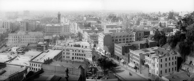
For more than 50 years, Broadway from 1st Street to Olympic Boulevard was the main commercial street of Los Angeles, and one of its premier theater and movie palace districts as well. It contains a vast number of historic buildings and is listed on the National Register of Historic Places.
Prior to the turn of the 20th century, the city's Central Business District was further north, along Spring and Main streets between the Plaza and 2nd Street. In 1895 J.W. Robinson's opened what was then considered a very large and impressive four-story department store at 239 S. Broadway,[15][16] signaling of the shift over the next decade and a half of the main shopping district to Broadway below 2nd Street.
Retail hub

From around 1905 through the 1950s, Broadway was considered the center of the city, where residents went to ornate movie palaces and live theaters, and shopped at major department stores and shops. See the Table of department stores on Broadway and Seventh streets below.
The square footage of the four largest department stores alone — Bullock's at 806,000 sq ft (74,900 m2), The Broadway at 577,000 sq ft (53,600 m2),[17] May Co. at over 1,000,000 sq ft (93,000 m2)[18] and J. W. Robinson's (7th St. at Hope) at 623,700 sq ft (57,940 m2)[19][20] — totaled over three million square feet, the size of American Dream Meadowlands, America's largest mall today.
Among dozens of significant buildings from that era are the Bradbury Building, Ace Hotel Los Angeles, and the Los Angeles Examiner building designed by Julia Morgan.
Some of the movie theaters on the street fell into disuse and disrepair, some were replaced with parking lots, but many have been repurposed and/or restored. The department stores closed in the 1970s and 1980s, but Broadway has been the premier shopping destination for working class Latinos for decades.[21]
Theater District
The Broadway Theater District is the first and largest historic theater district listed on the National Register of Historic Places (NRHP).[22] The district, which spans from 2nd to 10th street, contains twelve movie palaces.
Department stores
Broadway since 2008
In 2008, the City of Los Angeles launched a $40-million campaign to revitalize the Broadway district, known as the "Bringing Back Broadway" campaign. Some Latino merchants in the district expressed concern that the campaign was an effort to spread the largely Anglo gentrification taking hold in other parts of downtown to an area that has become the city's leading Latino shopping district.[23] A worker at one of the district's bridal shops noted, "On one side, I like the idea. The only thing is that I don't think they want our types of businesses."[23]
The Downtown's real estate revitalization, using the City's adaptive reuse ordinance that makes it easier for developers to convert outmoded and/or vacant office and commercial buildings into residential buildings, has reached the Broadway Historic District. It includes the transformation of the United Artists Theater office tower into the Ace Hotel Los Angeles, and restoration of its movie palace.
The Bringing Back Broadway commission is working on further reviving the landmark Los Angeles boulevard in the historic district. Led by City Councilman Jose Huizar, the commission has recommended widening sidewalks, eliminating traffic lanes, constructing new parking structures, and bringing back streetcar service reminiscent of the street's past.[24] A pedestrian-friendly project finished up in December 2014 that widened the sidewalks and replaced the parking lane with planters, chairs and round cafe tables with bright-red umbrellas. The Great Streets Initiative seeks to bolster the street-level health of the city by making several dozen boulevards more hospitable to pedestrians, cyclists and small businesses. Mayor Eric Garcetti said the effort represents "a shift from the way that our neighborhoods have been planned in Los Angeles," with a new focus on "walkability and transit."[25]
Broadway retail is transitioning from a broad mix of stores catering to Hispanic immigrants and a burgeoning sneaker and streetwear retail cluster has emerged from 4th to 9th streets: Sneaker Row.[26]
Retail in and around the Eastern Columbia, located at the intersection of 9th Street & Broadway, has proliferated in recent years with the opening of Acne Studios, Oak NYC, Aesop, Tanner Goods, BNKR, Austere, A.P.C., and Urban Outfitters located in the Rialto Theater (Los Angeles Historic-Cultural Monument No. 472).[27][28]
Buildings and sites
Summarize
Perspective
This section may contain an excessive amount of intricate detail that may interest only a particular audience. (November 2024) |
This section contains too many pictures for its overall length. (November 2024) |
North of Hollywood Freeway
 Broadway Tunnel at Fort Moore Hill (1901), southern entrance
 Chinatown East Gate


- Chinatown East Gate, 943 N. Broadway
- Little Joe's (razed), 904 N. Broadway
- Site of Broadway Tunnel (1901–1941) below Fort Moore Hill (leveled), between today's Temple St. and César Chávez Bl.
Hollywood Freeway to Temple
This area south to Second Street was Los Angeles's Central Business District during the 1880s and 1890s. It is now the Civic Center.
 1905 view south on Broadway from Temple. Times Mirror printing house in foreground, marked 110 N. Broadway. The 1888 City Hall towers on Broadway's 200 block in the distance. Fort Moore Hill, now leveled, at right.
 c.1893–1900, looking east at Broadway along Third from Bunker Hill
.jpg)
.jpg)
Temple and Broadway
Cable cars of the Temple Street Cable Railway ran along Temple Street starting in 1886 and were replaced with Pacific Electric streetcars in 1902.[29][30]
Northwest corner
 Women's Christian Temperance Union Temple, 1890

- The three-story brick Women's Christian Temperance Union building was erected in 1888 for $45,000.[31] Also known as the Temperance Temple, it has been demolished[32] and was replaced in 1957 by the Los Angeles County Central Heating and Refrigeration Plant.[33]
Southeast corner
 Los Angeles High School on Pound Cake Hill, 1870s
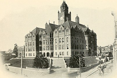 "Red Stone" Courthouse and Post Office (1891-1936)
 Hall of Records (1911–1973)
 Clara Shortridge Foltz courthouse

_(14783523833).jpg)


This location was at the time known as Pound Cake Hill. The buildings located here faced New High Street to their east and Broadway to their west. They were as follows:[34]
- Los Angeles High School, whose original location (1873-1887) was between New High on the west and Broadway on the east, south of Temple Street. It was moved to California and Sand streets, and in 1890 a new facility was built on Fort Moore Hill, immediately north of where Broadway today crosses the Hollywood Freeway. The Pound Cake Hill school was demolished and replaced by:
- First, the Red Stone Courthouse (or "Red Sandstone Courthouse"), which took over the function of courthouse from the Clocktower Courthouse (also called the Temple Courthouse). It was damaged beyond repair by the Long Beach earthquake of 1933 and was torn down in 1936.
- The Los Angeles County Hall of Records was built next to (south of) the Red Sandstone Courthouse in 1911, After the 1971 San Fernando earthquake, it was determined to be unsafe and it was demolished in 1973. A new Hall of Records had been built and opened in 1962, one block west on the south side of Temple between Broadway and Hill.
Currently on the site are:
- Clara Shortridge Foltz Criminal Justice Center (Los Angeles County Grand Jury), originally known as the Criminal Courts Building, opened in 1972
- A portion of Grand Park, which stretches mid-block between Temple and First, from City Hall at Spring Street, to the Music Center at Grand Avenue.
Southwest corner
- The second location of the Los Angeles County Hall of Records, opened 1962.
Adjacent to the south, mid-block, is a portion of Grand Park.
First and Broadway
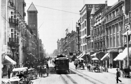 Looking south along Broadway from First, 1904-5. At right, from left to right: C.H. Frost Building, 141-3, the turreted Roanoke Bldg, Newell & Gammon Bldg., Mason Opera House. At left, Chamber of Commerce, 1888 City Hall.

Northeast corner
,_photo_about_1887.jpg)
- Los Angeles Times building, 1886. This building was razed after a 1910 bombing and a new headquarters was opened on this site in 1912. The newspaper later moved further south on Spring Street to the Los Angeles Times building, now part of Times Mirror Square, occupying the entire block between Broadway, Spring, First and Second streets.[35]
Northwest corner
- Site of the Tajo Building (1896–mid-20th c.).[36] Now the location of the Los Angeles County Law Library.[37]
Southeast corner and east side of 100 block
 Times Mirror Square 1973 Pereira addition
 Postcard c.1910 of Chamber of Commerce


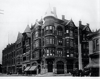
- Site of the Culver Block retail and office building.[38] Now the site of the Times Mirror Square 1973 Pereira Addition, so called because it was designed by William Pereira.
- South of the Culver Block was the Los Angeles Chamber of Commerce Building, 128–130 S. Broadway, opened February 12, 1904,[39] a landmark at the time featured on postcards and in books. 6 stories, 4 floors. Ground floor offices included those of the Los Angeles Herald and Consolidated Bank.[40]
Southwest corner

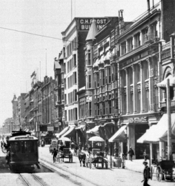 From left to right: C.H. Frost Building, Roanoke Bldg., Newell & Gammon Bldg., and Mason Opera House


The southwest corner, during Victorian times the site of unremarkable retail and office buildings, was from 1958 the location of the State Office Building, (1958-60, architect Anson C. Boyd, razed 2006). It was named the Junipero Serra State Office Building, and this moniker would be transferred to the former Broadway Department Store building at 4th and Broadway when it was opened to replace this building in 1998.[41] It is now the location of the New U.S. Courthouse built in 2016, taking up the entire block between Broadway, Hill, First and Second.[42]
Just south of the southwest corner was the Mason Theatre, 127 S. Broadway. Opened in 1903 as the Mason Opera House, 1,600 seats. Benjamin Marshall of the Chicago firm Marshall & Wilson designed the building in association with John Parkinson. Marshall is known for designing the Iroquois Theatre in Chicago. Remodeled in 1924 by Meyer & Holler. Later, as the Mason Theatre, it showed Spanish-language films. Demolished 1955.[43]
145 S. Broadway,[44]site of the C. H. Frost Building, later known as the Haig M. Prince Building. Built 1898, architect John Parkinson,[45] Now the location of the new United States Courthouse built in 2016, taking up the entire block between Broadway, Hill, First and Second.[42]
Second and Broadway
 Broadway looking south from 2nd, 1895-1905
.jpg)
Northeast corner
 Hellman Building, 1918

One of several Hellman Buildings across Downtown L.A. — not to be confused with the still-existing Hellman Building at Fourth and Spring — was located here (#138) from 1897 to 1959.[46] The site is now a parking structure, part of the Times Mirror Square complex.
Southwest corner and west side of 200 block
 American National Bank Building, southwest corner, 1890. To the left are the turret and two gables of the YMCA Building (1889), then the Potomac Block (1890)
 Merchants Trust Company Building, 1910
 Potomac Block c.1890-1895
 Ville de Paris department store, 1901
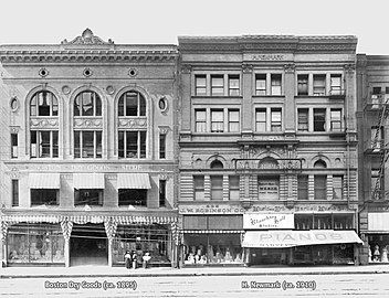 Boston Dry Goods and Harris Newmark buildings, 1899

.jpg)


The west side of the 200 block of South Broadway had a key place in the retail history of Los Angeles from the 1893 through 1917, as it was home to several prominent early department stores such as the Ville de Paris, Coulter's department store from 1905–1917, and J. W. Robinson's "Boston Dry Goods" store from 1895–1915. All three stores would move to Seventh Street when it became the upscale shopping street between 1915 and 1917.
- On the southwest corner of 2nd and Broadway was Judge O'Melveny's house, built in 1870. This was replaced by the American National Bank (later California Bank) Building, which one turn was replaced by the California Building in 1911. Nos. 201-213 Broadway are now known named the Broadway Media Center.
Further south on the west side of Broadway, was 207–211, location of the:
- YMCA Building (#207–209–211), Romanesque Revival architecture, opened in July 1889, demolished in 1903.
- The YMCA operated here at #207 from 1889 until 1903,
- City of London opened here in August 1891, run by Messrs. Hiles and Niccolls, who came from the City of Paris department store. It carried curtains, window shades, comforters, and the like.[47] It operated here until August 1895, when it moved next door to the Potomac Block at #213.[48]
The YMCA Building was demolished to make way for the:
- Merchants Trust Co. Building.[49]
Coulter's complex
The adjacent Potomac Block and Bicknell Block originally housed prominent retailers of the day, then were joined together in 1906 by Coulter's department store to form a complex, opening it as a new, 157,000 sq ft (14,600 m2) store in June, 1905.[50][51][52]
Potomac Block
The Potomac Block, 213–223 S. Broadway, was from 1905 to 1917 known as the B. F. Coulter Building. It was originally developed by lumberyard and mill owner J. M. Griffith. It was designed in 1888 by Block, Curlett and Eisen in Romanesque architectural style[53] and opened on July 17, 1890.[54]
Tenants included:
- Ville de Paris department store (at 221–223, from 1893 through 1906),[53]
- City of London Dry Goods Co., which moved here from next door at #211 in August 1895 and advertised for this location through August 1899.[48]
It was the first time major retail stores opened on South Broadway, in what would be a shift of the upmarket shopping district from 1890 to 1905 from around First and Spring to South Broadway. In 1904, Coulter's bought the Potomac Block, and combined it with the Bicknell block to create its new store that opened in 1905.
After Coulter's moved:
- 215 continued as a branch of Coulter's through 1927. Then, 215–217 was home to the Pacific Furniture House in the 1940s.
- 219 housed Fisch's Department Store in the 1940s.
The building was demolished in 1953 and is still the site of a parking lot.[55]
Bicknell Block
The Bicknell Block (or Bicknell Building) at 225–229 S. Broadway, with back entrances at 224–228 S. Hill Street. was part of Coulter's from 1905 from 1917. After Coulter's moved in 1917, it housed the Western Shoe Co. (through 1922), later known as the Western Department Store (1922–1928). Lettering covered the face of the building from top to bottom through the end of the 1950s: "THE LARGEST SHOE DEPT. IN THE WEST".[56]
Further south
- 231-235, the Harris Newmark Building (1899, Abram Edelman), Bartlett Music Co. (#233), annex to J. W. Robinson's (#235); Goodwill Industries store (#233-235, 1950s–60s). The building still stands, but all floors except the ground floor have been removed.
- 237-241, the Boston Dry Goods Building (completed 1895, demolished, architects Theodore Eisen and Sumner Hunt, designer of the Bradbury Building)[57][58] The building was home to J. W. Robinson's "Boston Dry Goods" store from 1895 to 1915, Scott's Department Store (239–241, 1920s), Third Street Store (237–241, 1950s–60s). Demolished, currently the site of a parking lot.
- 251 was home to the I. Magnin speciality department store, which opened here on January 2, 1899;[59] starting 1904, I. Magnin announced that the store would be known by the name of its manager, Myer Siegel.[60]
Southeast corner and east side of 200 block
 Looking north along Broadway, east side, past 2nd Street. From top left: Los Angeles Times Bldg., the 1911 Hall of Records behind it, the Chamber of Commerce Bldg., Hellman Bldg., Nolan, Smith and Bridge Bldg., Gordon Bldg., Crocker Bldg., Copp Bldg., 1888 City Hall

 Los Angeles City Hall (1888–1928)
 B'nai B'rith Temple (opened 1873)

,_then_called_Fort_Street,_Los_Angeles.png)

The southeast corner of 2nd and Broadway was the site of:
- First Presbyterian Church in 1894.[61] The church was replaced sometime before 1906
- Nolan, Smith and Bridge Building, #200-4 S. Broadway, stores and a restaurant.[62]
- Now the corner is the site of the Historic Broadway underground light rail station.
Mid-block were:
- Crocker Building, #212–6[63] Home to Victor Clothing from 1920 to 1964
- B'nai B'rith Temple (1873), 214 S. Broadway (post-1890 numbering), the city's first synagogue, razed to make way for the Copp Building, 218–224 S. Broadway, home to the original (1908) Pig 'n Whistle candy shop and tea room.[64] The Pig 'n Whistle would open locations at 7th and Broadway and in Hollywood, where it would become a landmark restaurant that still operates today.
- City Hall (1888–1928; opened 1888, demolished 1929; 228–238 S. Broadway, architect Solomon Irmscher Haas, Romanesque Revival). Now a parking lot. Three stories, it had a 150-foot (46 m) campanile. Red and brown brick. Housed the Los Angeles Public Library for a time until it moved to the new Hamburger's department store building at Eighth and Broadway in 1908.[65] The site is now part of the "(213) S. Spring" parking garage.[37]
- #240-246 the Hosfield Building, location of the Natatorium (indoor swimming pool) in 1894 and the Imperial Restaurant in 1906.[63] After 1964, location of Victor Clothing, notable for its changing murals reflecting local Chicano culture. Victor Clothing operated here until 2001, and was known for its frequent ads on Spanish-language television.[66]
Third and Broadway
Northwest corner
 Irvine-Byrne Building (built 1895)

The corner is home to one of the oldest buildings outside the Plaza area, the 1895 Irvine-Byrne Building or Irvine Block or Byrne Building; now called the Pan American Lofts. The architect was Sumner Hunt. It was built in a hybrid Spanish Colonial Revival/Beaux-Arts style.
The building was home to the renowned I. Magnin clothing store that opened here on January 2, 1899;[67] on June 19, 1904, I. Magnin announced that the Los Angeles store would henceforth be known as Myer Siegel.[60] After a fire at the Irvine Byrne Building destroyed its store on February 16, 1911, Myer Siegel moved further south on Broadway.
It was modernized and converted to lofts in 2007 and given its present name. The halls and staircase have appeared in many films and television commercials.[68]
From Third Street south to Olympic Blvd. (originally Tenth St.), and from Hill Street east to Los Angeles Street, including Broadway, is the Historic Core district, the city's main commercial and entertainment area in the first half of the 20th century.
Northeast corner
 Broadway, east side, looking south past 3rd, c.1903-4. From left to right: 1888 City Hall, Rindge Block, Bradbury Building
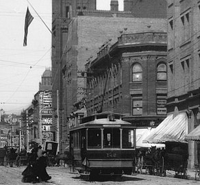 Broadway, east side, looking north past 3rd, c.1888. From left to right: 1888 City Hall, Rindge Block, Bradbury Building

,_Rindge_Block_at_NE_corner_of_3rd,_Bradbury_Building.jpg)
On this corner:[69]
- Originally the J. C. Graves house stood here; Graves bought the property in 1879 for $2,250. The house was sold and removed to 10th and Hope streets in 1888.
- Rindge Block (1898, sold in 1899 for $190,000 to Frederick H. Rindge, the "King of Malibu"), 248–260 S. Broadway, commercial building; the top floors were removed and only the ground floor remains.
Southwest corner
 Million Dollar Theatre

- Million Dollar Theatre, (1917-8, architects Albert C. Martin and William Lee Woollett, Spanish Baroque Revival style, 2,345 seats), 307 (orig. 301–313) S. Broadway. It is the northernmost of the movie palaces that comprise the Broadway Theater District and is listed in the National Register of Historic Places.[70] Built by Sid Grauman who would later open Grauman's Chinese Theatre in Hollywood. The theater was designed by architects with a fanciful facade in the Churrigueresque style. After more than 30 years as one of the city's most prestigious first-run movie palaces, the Million Dollar Theater presented Spanish-language films and variety shows from 1950 until the late 1980s. The theater had a seating capacity of 2,345 when it opened in 1918.[71]
- Before that, from c. 1895–1917, the Muskegon Block stood on the site,[72] (built c. 1895),[73] named after Muskegon, Michigan where its developer Thomas Douglas Stimson had made his fortune in lumber. From 1905–1917, the Ville de Paris department store was located next door at the Homer Laughlin Building, and the Muskegon Block housed retail tenants such as millinery, men's furnishings, jewelry, piano and music stores,[74] as well as offices.
Southeast corner
 Bunker Hill to Bradbury Building and Stimson Block. 1894–5.
 Bradbury Building, 1894


- Bradbury Building (1893, architects Sumner Hunt and George Wyman, Italian Renaissance Revival, Romanesque Revival, and Chicago School styles), the oldest remaining commercial building in Downtown Los Angeles. The Los Angeles Conservancy calls it an icon and a "unique treasure". Commissioned by gold-mining and real estate millionaire Lewis Bradbury. It is famous for its light-filled atrium, open cage elevators, marble stairways and ornate iron railings, and has appeared in many films including Blade Runner.[71]
Third to Fourth
West side
 Ville de Paris department store in the Homer Laughlin Building, c. 1905
 Homer Laughlin Building, 2014
 West side of the 300 block, 1905
 Karl's Building, 1909


- Homer Laughlin Building (1896, John Parkinson), 317 S. Broadway, home to Grand Central Market since 1917. Previously home to Coulter's (1898–1905) and Ville de Paris (1905–1917)
- 327–329 S. Broadway, former J. R. Lane Dry Goods store, then Field's jewelry store and the Broadway food market. Now a food court. Top floors removed; now single story.[37]
- Jacoby Building (John B. Parkinson[75]), 331–335 S. Broadway, Jacoby Bros. department store 1900-1935,[76] Boston Store late 1930s.[77] Two of four floors removed[78]
- former Haggarty's department store from 1905[79] to 1917, 337–339 S. Broadway[80]
- Karl's Building (1903, Abram M. Edelman) 341–345 S. Broadway[1] former J. M. Hale department store from 1909[81] through the 1920s.
- Zobel Building (c. 1912),[1] 351-353 S. Broadway, former site of The Wonder, opened 1921, largest retail silk store in the United States[82]
- Grant Building (1898, Frank Van Trees), 355–363 S. Broadway, originally Grant Block, three stories,[83] enlarged to 7 stores 1901–2 by John Parkinson,[84] now two stories.[85] Home to W. E. Cummings shoe store, then Montgomery Bros jewelry store,[86] then Weatherby-Kayser[87]
East side
- Blackstone Building (1907), 318–322 S. Broadway,[88] housed Blackstone's Department Store 1907-1917, as well as a Los Angeles County Library and the Cozy Theater. Originally five stories, now three[89]
- Trustee Building (1905, Parkinson and Bergstrom),[88] 340 S. Broadway, home to various retail stores including Columbia Outfitting in the 1920s.
- O. T. Johnson Block (1895, Robert Brown Young), 350 S. Broadway, originally three stories,[90] now one[37]
- O. T. Johnson Building (1902, John Parkinson),[90] 356–364 S. Broadway, NE corner of 4th and Broadway, originally seven stories,[91][92] now two[37]
Fourth to Fifth
West side
- Junípero Serra State Office Building, (1915, Parkinson and Bergstrom), SW corner of 4th and Broadway, former home to The Broadway
- Wilson Building (1909), 431 S. Broadway, former home to Woolworth's
- Metropolitan Building, (1913, Parkinson and Bergstrom), NW corner of 5th and Broadway, former home of Owl Drug Co., (1914–1934), L.A. Public Library (1913–1926), J. J. Newberry (1939-1990)
East side


 NE corner 5th/Broadway, early 1920s


- Perla on Broadway (2022), 400 S. Broadway, 35-story condominium tower
- Site of first Thrifty Drug Store (razed), 412 S. Broadway
- Judson-Rives Building (1906, Charles Ronald Aldrich), 424 S. Broadway, ten stories, currently The Judson
- Bumiller Building (1906, Morgan & Walls), 430 S. Broadway, six stories, currently the Broadway Lofts
- Broadway Mall (1980s), 440 S. Broadway, former site of the Parmalee-Dohrmann building[93]
- Chester Williams Building (1926, Curlett & Beelman), NE corner of 5th and Broadway, twelve stories
Fifth to Sixth
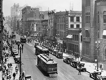
 Broadway looking south from 5th Street, 1950s

West side
 West side of Broadway south from 5th, 1927 postcard
 North from 6th, c.1906

.jpg)
.jpg)

_01.jpg)
- Fifth Street Store Building (1927, Alexander Curlett), 501 S. Broadway, former home to Steele, Faris, & Walker Co. (1905–1909), Fifth Street Store (1909–1925),[94][95] Walker's (1926–1946),[96] Milliron's (1946–1953),[96] Ohrbach's-Downtown (1953–1959)[97]
- Remick Building (1902, Abram M. Edelman), 517-19 S. Broadway
- Reeves Building (1903, John Parkinson), 525 S. Broadway
- Schulte United Building (1928), 529 S. Broadway
- Lerners Building (1931, Philip Barker), 533 S. Broadway
- F. and W. Grand Silver Store Building (1931, Walker & Eisen, 537-541 S. Broadway. Home to F. & W. Grand Silver (1931–1934), National Dollar (1934), Richman Brothers (1950s), and Hartfield-Zodys (1960s)[98]
- Swelldom Building (1920, Davis & Davis and Henry F. Withey),[99] 555–561 S. Broadway, Swelldom opened in the building 1920.[100][101]
East side
 Title Guarantee Block, a.k.a. Jewelry Trades Building


 Postcard, looking south, circa 1930 to 1945

,_510-512_S._Broadway_Los_Angeles.jpg)


.jpg)
- Jewelry Trades Building (1913, Morgan, Walls and Morgan), 500 S. Broadway
- Pettebone Building (1905, Robert Brown Young), 510-512 S. Broadway
- Roxie Theatre (1931, John M. Cooper), 518 S. Broadway, 1600 seat movie palace[2]
- Cameo Theater – (1910, Alfred Rosenheim), 528 S. Broadway, originally 900-seat Nickelodeon,[2] converted to retail[102]
- Arcade Theater (1910, Morgan and Walls), 534 S. Broadway, 1450-seat English-music-hall theater[2] Converted to retail
- Broadway-Spring Arcade (1924, MacDonald and Couchot), 540 S. Broadway
- Hubert-Thom McAn Building, (1900, John B. Parkinson) 546 S. Broadway
- Silverwood's Building (1920, Walker and Eisen), 556-8 S. Broadway, former home to Silverwoods, five stories[88]
Sixth to Seventh
West side
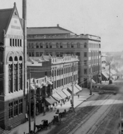
 W. side of Broadway, 600 block c.1907–9
 Central Department Store and H. Jevne Building, 1920s postcard
 Yamato Inc. in the Hoffman Building, 1910 postcard
.jpg)


- H. Jevne Company Building (1906-7, Parkinson & Bergstrom), 603 S. Broadway, site of Norton Block prior to 1906[103]
- Hotel Palms, repurposed for retail in 1906-7[104]
- Central Department Store (Samuel Tilden Norton), three stories[105]
- Los Angeles Theatre (1931, S. Charles Lee and S. Tilden Norton), 615 S. Broadway, 2000-seat movie palace[2]
- Mailing's (1930, S. Charles Lee), 617-619 S. Broadway, Myer Siegel previously located here (1921 or 1922-1927)[106]
- former S. H. Kress, 621-625 S. Broadway
- Hoffman (1906), 635-637 S. Broadway, former home to Yamato Inc.
- St. Vincent's Jewelry Mart, NW corner of 7th and Broadway, formerly Bullock's dept. store
East side
 Broadway 600 block, east side, 1923
 Broadway 600 block, east side, 2012


.jpg)
- Walter P. Story Building (1909, Morgan & Walls) 600-610 S. Broadway, SE corner of 6th and Broadway, former hom to Mullen & Bluett
- Desmond's Building (1924, Albert C. Martin, Sr.), 616 S. Broadway. Housed Desmond's flagship store 1924-1981, six stories[107]
- Schaber's Cafeteria Building (1928, Charles F. Plummer), 620 S. Broadway
- Palace Theatre (1911, G. Albert Lansburgh), 630 S. Broadway, 2200-seat originally 1068-seat today vaudeville theater and movie palace[2]
- Forrester Building (1907, Charles Frederick Whittlesey), 638 S. Broadway
- J. E. Carr Building (1908-9, Robert Brown Young),[108] 644–646 S. Broadway, home to Harris & Frank 1947–1980.[109]
- Clifton's Cafeteria, 648 S. Broadway, formerly Boos Bros. Cafeteria
Seventh to Eighth


West side
.jpg)
- State Theatre (1921, Weeks & Day), 703 S. Broadway, 2,450-seat vaudeville theater and movie palace[110]
- F.W. Woolworth Building (1920, Weeks & Day), 719 S. Broadway, currently a Ross Dress for Less
- Cheney Block (1913), 731-733 S. Broadway
- Rowley Building (1908), 735 S. Broadway
- Issacs Building (1913), home of Reich and Lièvre, 1917-ca. 1927, 739-745 S. Broadway
- Merritt Building (1915, Reid & Reid), 761 S. Broadway
East side

 Chapman Building, 1910s

,_ca.1913-1918_(CHS-2321).jpg)

- Site of Hotel Lankershim (1905, Robert Brown Young), 700 S. Broadway, demolished 1980s
- Yorkshire Hotel (1909, Parkinson and Bergstrom), 710-714 S. Broadway
- Parmelee Building (1907, Parkinson and Bergstrom), 716 S. Broadway
- Barker Brothers Building (1909, Robert Brown Young), 722 S. Broadway
- Globe Theatre in the Garland Building (1913, Morgan, Walls & Morgan) 744 S. Broadway, 2000-seat movie palace
- Chapman Building (1912-3, Ernest McConnell), 756 S. Broadway, northeast corner of 8th Street, thirteen stories[111][112][113]
Eighth to Ninth
West side
 May Co. Building, 1912
_on_the_corner_of_Eighth_Street_and_Broadway,_Los_Angeles,_ca.1912_(CHS-5541).jpg)

- May Company Building (1906, Alfred F. Rosenheim), 829 S. Broadway
- Eastern Columbia Building (1930, Claud Beelman), 849 S. Broadway, considered "the jewel of downtown"
East side

.JPG)


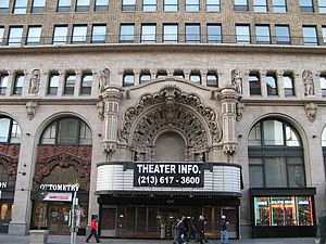
- Tower Theatre (1927, S. Charles Lee), 802 S. Broadway, originally a 1000-seat theater,[114] now an Apple Store
- Singer Building (1922, Meyer & Holler), 808 S. Broadway, bought by Singer Sewing Machine Company in 1939
- Rialto Theatre (1917, Oliver Perry Dennis, 1923-remodel William Lee Woollett), 812 S. Broadway, former nickelodeon, now retail[115][116][117]
- Wurlitzer Building (1923, Walker and Eisen), 818 S. Broadway
- Braun Building (1913, Walter Jesse Saunders), 820-822 S. Broadway
- Platt Building (1927, Walker and Eisen), 830 S. Broadway[118]
- Orpheum Theatre (1926, G. Albert Lansburgh), 842 S. Broadway, 1976-seat theater[2]
- Ninth and Broadway Building (1930, Claud Beelman), 850 S. Broadway[119]
Ninth to Olympic
West side

_LC-HS503-453.jpg)
- Blackstone's Department Store Building (1916, John and Donald Parkinson, first floor facade remodel by Morgan, Walls & Clements in 1939), 901 S. Broadway
- Ace Hotel Los Angeles (1927, Walker & Eisen),[21] 921-933 S. Broadway, houses United Artists Theater (1927, Charles Howard Crane), a 2214-seat movie palace[2]
- Western Costume Building (1925, Kenneth A. MacDonald Jr.), 939 S. Broadway
East side
- Broadway Leasehold Building (1914, Meyer & Holler), 908 S. Broadway[120]
South of Olympic
West side
 Herald Examiner Building

- Los Angeles Herald-Examiner Building (1914, Julia Morgan), SW corner 11th and Broadway[121]
- Athens Park, 124th to El Segundo Blvd on Broadway
- Globe Department Store, 51st and Broadway[122]
East side
- Los Angeles Railway Building (1925, Noerenberg & Johnson), 1060 S. Broadway, home to The Hoxton[123]
- Proper Hotel (1926, Curlett & Beelman), 1100 S. Broadway[124]
Public transportation
The Los Angeles Metro Rail's Historic Broadway station is an underground light rail station near the intersection of 2nd and Broadway,[125][126] which is served by the E Line east to East Los Angeles and west to Santa Monica, and on the A Line northeast to Union Station, Pasadena, and Azusa and south to Long Beach.[127]
Metro J Line bus rapid transit (BRT) has 5 stations adjacent to Broadway in South Los Angeles: 37th Street/USC, Slauson, Manchester/I-110, Harbor Freeway, and Rosecrans. These stations are along the Harbor Transitway, a dedicated busway between Downtown L.A. (Adams Blvd.) and the Harbor Gateway, near Carson, in the median of the Harbor Freeway (I-110), just west of Broadway. J Line BRT runs as far south as San Pedro and as far northeast as El Monte.
Metro Local bus line 45 serves most of the length of Broadway, between Lincoln Heights through Downtown to the Harbor Freeway Station. Local routes 4, 30, and 40 serve portions of Broadway downtown.
See also
References
External links
Wikiwand - on
Seamless Wikipedia browsing. On steroids.