Bad Lauterberg
Place in Lower Saxony, Germany From Wikipedia, the free encyclopedia
Place in Lower Saxony, Germany From Wikipedia, the free encyclopedia
Bad Lauterberg is a town in the district of Göttingen, in Lower Saxony, Germany. It is situated in the southern Harz, approx. 15 km southwest of Braunlage, and 20 km southeast of Osterode am Harz.
Bad Lauterberg | |
|---|---|
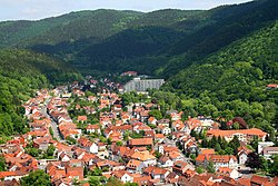
 General view of the town | |
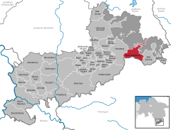
Location of Bad Lauterberg within Göttingen district  | |
| Coordinates: 51°37′54″N 10°28′14″E | |
| Country | Germany |
| State | Lower Saxony |
| District | Göttingen |
| Subdivisions | 4 districts |
| Government | |
| • Mayor (2021–26) | Rolf Lange[1] (CDU) |
| Area | |
| • Total | 41.54 km2 (16.04 sq mi) |
| Elevation | 296 m (971 ft) |
| Population (2022-12-31)[2] | |
| • Total | 10,297 |
| • Density | 250/km2 (640/sq mi) |
| Time zone | UTC+01:00 (CET) |
| • Summer (DST) | UTC+02:00 (CEST) |
| Postal codes | 37431 |
| Dialling codes | 05524 |
| Vehicle registration | GÖ, OHA |
| Website | www.badlauterberg.de |
Bad Lauterberg is known inter alia for the liqueurs, Schierker Feuerstein and Harzer Grubenlicht, which are both manufactured and bottled here.
Bad Lauterberg was the birthplace (1879) of the Polar explorer Alfred Ritscher.
Town Council after the local elections on September 11, 2016:
About a mile east of the town in the mountains is the viewing point of Hohe Tür which is by a mountain lake and on the main Weser-Elbe watershed. It is checkpoint 43 in the Harzer Wandernadel hiking network.[3]
Seamless Wikipedia browsing. On steroids.
Every time you click a link to Wikipedia, Wiktionary or Wikiquote in your browser's search results, it will show the modern Wikiwand interface.
Wikiwand extension is a five stars, simple, with minimum permission required to keep your browsing private, safe and transparent.