Athis-Val de Rouvre
Commune in Normandy, France From Wikipedia, the free encyclopedia
Athis-Val de Rouvre (French pronunciation: [atis val də ʁuvʁ]) is a commune in the department of Orne, northwestern France, the municipality was established on 1 January 2016 by merger of the former communes of Athis-de-l'Orne (the seat), Bréel, La Carneille, Notre-Dame-du-Rocher, Ronfeugerai, Ségrie-Fontaine, Taillebois and Les Tourailles.[3]
Athis-Val de Rouvre | |
|---|---|
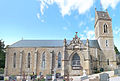
 The church in Athis-Val-de-Rouvre | |
Location of Athis-Val de Rouvre  | |
 Athis-Val de Rouvre  Athis-Val de Rouvre | |
| Coordinates: 48°48′40″N 0°29′56″W | |
| Country | France |
| Region | Normandy |
| Department | Orne |
| Arrondissement | Argentan |
| Canton | Athis-Val de Rouvre |
| Intercommunality | CA Flers Agglo |
| Government | |
| • Mayor (2020–2026) | Alain Lange[1] |
| Area 1 | 76.97 km2 (29.72 sq mi) |
| Population (2021)[2] | 4,216 |
| • Density | 55/km2 (140/sq mi) |
| Time zone | UTC+01:00 (CET) |
| • Summer (DST) | UTC+02:00 (CEST) |
| INSEE/Postal code | 61007 /61430, 61100 |
| 1 French Land Register data, which excludes lakes, ponds, glaciers > 1 km2 (0.386 sq mi or 247 acres) and river estuaries. | |
Geography
The commune is part of the area known as Suisse Normande.[4]
The commune is made up of the following collection of villages and hamlets: Le Rocher Nantreuil, La Tarillée, La Motte, Ronfeugerai, La Fosse, La Mancelière, L'Être Hardy, La Pigeonnière, La Carneille, Taillebois, Le Hamel, Les Onfrairies, Les Tourailles, Notre-Dame-du-Rocher, Ségrie-Fontaine, Oëtre, Le Douit de Bréel, Bréel, Le Val Fermé and Athis.[5]
The Commune with another 20 communes shares part of a 2,115 hectare, Natura 2000 conservation area, called the Vallée de l'Orne et ses affluents.[6]
The commune has three rivers running through it, the Vere, the Gine and the Rouvre. In addition there are five streams running through the commune, Aubusson, Meheudin, Ferronniere, Fontaine and Onfrairies.[7]
Population
| Year | Pop. | ±% p.a. |
|---|---|---|
| 1968 | 3,739 | — |
| 1975 | 3,885 | +0.55% |
| 1982 | 4,194 | +1.10% |
| 1990 | 4,175 | −0.06% |
| 1999 | 4,066 | −0.29% |
| 2007 | 4,298 | +0.70% |
| 2012 | 4,319 | +0.10% |
| 2017 | 4,256 | −0.29% |
| Source: INSEE[8] | ||
Notable buildings and places
Jardin Intérieur à Ciel Ouvert is a contemporary garden that was made open to the public in 2011, featuring over 1,200 species of plants.[9] It is classified as a Jardins remarquables by the Ministry of Culture and the Comité des Parcs et Jardins de France.[10]
National heritage sites
The Commune has 6 buildings and areas listed as a Monument historique.
- Martinique cotton spinning factory a nineteenth century spinning factory, based in Athis-de-l'Orne that is still being used today .[11]
- Croix de pierre a sixteenth century cross in La Carneille.[12]
- Church of Saint-Vigor a nineteenth century church in Athis-de-l'Orne, designed by architect Ruprich-Robert and the walls were decorated by artist Louis Chifflet.[13]
- Church of Saint-Pierre and Saint-Paul a modern church in Bréel that contains a chapel from the end of the 15th century, intended for the burial of the Corday family.[14]
- Hamel Saint-Etienne Lodge a 15th century lodge in La Carneille.[15]
- Logis dit la Cour a 15th century Manor house in Taillebois.[16]
 Church of SaintPierre-et-SaintPaul in Breel-by Rundvald
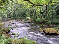 Gorges of la Rouvre
 Château des Hayes
 Notre Dame Du Rocher
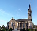 Ronfeugerai church
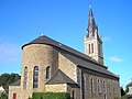 Segrie Fontaine church
 Chateau de Segrie
 Taillebois
 church of Saint-Laurent in Taillebois
 Les Tourailles Basilique
 Les Tourailles Chateau


Notable People
- Antoine de Montchrestien -(c. 1575 - 1621) a French soldier, dramatist, adventurer and economist, died here in Les Tourailles.[17]
Twin towns
See also
References
Wikiwand in your browser!
Seamless Wikipedia browsing. On steroids.
Every time you click a link to Wikipedia, Wiktionary or Wikiquote in your browser's search results, it will show the modern Wikiwand interface.
Wikiwand extension is a five stars, simple, with minimum permission required to keep your browsing private, safe and transparent.