Aranda de Duero
Municipality in Castile and León, Spain From Wikipedia, the free encyclopedia

Aranda de Duero is a city and municipality, capital of the Ribera del Duero comarca, in the south of the province of Burgos, in Castile and León, Spain. It has a population of roughly 33,000 people and lies on the River Duero.
This article includes a list of general references, but it lacks sufficient corresponding inline citations. (November 2018) |
You can help expand this article with text translated from the corresponding article in Spanish. (January 2013) Click [show] for important translation instructions.
|
Aranda de Duero | |
|---|---|
From top, left to right: Santa María la Real Church, Town Hall, San Juan Church, Plaza Mayor, and stairs cut into rock leading to a wine cave. | |
.svg) Flag .svg) Coat of arms | |
 Aranda de Duero Location in Spain  Aranda de Duero Aranda de Duero (Spain) | |
| Coordinates: 41°41′N 3°41′W | |
| Country | Spain |
| Autonomous community | Castile and León |
| Province | Burgos |
| Comarca | Ribera del Duero |
| Founded | 961 |
| Government | |
| • Mayor | Antonio Linaje Niño (Sentir Aranda) |
| Area | |
• Total | 127.28 km2 (49.14 sq mi) |
| • Land | 126 km2 (49 sq mi) |
| Elevation | 798 m (2,618 ft) |
| Population (2020)[1] | |
• Total | 33,187 |
| Demonyms | Arandino, Arandina |
| Time zone | UTC+1 (CET) |
| • Summer (DST) | UTC+2 (CEST) |
| Postal code | 09400 |
| Rivers | Arandilla, Duero, Bañuelos |
| Website | arandadeduero |


.jpg)
Description
The municipality of Aranda de Duero is made up of three towns: Aranda de Duero (seat or capital), La Aguilera and Sinovas.
Aranda de Duero is the capital of the Ribera del Duero wine region. The town is unique for having wine cellars that interconnect below the streets of the town centre. Wine clubs (peñas) celebrate special events in these cellars.
Location
Aranda de Duero is at the junction of several transport routes across Spain. The N1 autovía (known as A-1) runs north / south by Aranda, along which visitors and import/export goods travel between Madrid and the south coast. Another important road running east to west connects Portugal with important cities on the way (e.g. Zamora, Valladolid, Soria) and the east coast. Its location at the juncture of these routes has led to Aranda de Duero acquiring a growing recognition and function as a business centre. Several multinational corporations, such as Michelin and GlaxoSmithKline have large facilities in the area.
Climate
Aranda de Duero has a warm-summer Mediterranean climate (Köppen Csb) with cold winters.
| Climate data for Aranda de Duero, 1981–2010 | |||||||||||||
|---|---|---|---|---|---|---|---|---|---|---|---|---|---|
| Month | Jan | Feb | Mar | Apr | May | Jun | Jul | Aug | Sep | Oct | Nov | Dec | Year |
| Mean daily maximum °C (°F) | 8.5 (47.3) |
10.9 (51.6) |
14.6 (58.3) |
16.1 (61.0) |
20.3 (68.5) |
26.1 (79.0) |
30.0 (86.0) |
29.4 (84.9) |
25.0 (77.0) |
18.8 (65.8) |
12.6 (54.7) |
9.1 (48.4) |
18.5 (65.2) |
| Mean daily minimum °C (°F) | −1.5 (29.3) |
−1.4 (29.5) |
0.5 (32.9) |
2.6 (36.7) |
6.0 (42.8) |
9.5 (49.1) |
11.4 (52.5) |
11.1 (52.0) |
8.3 (46.9) |
5.2 (41.4) |
1.5 (34.7) |
−0.6 (30.9) |
4.4 (39.9) |
| Average rainfall mm (inches) | 29.9 (1.18) |
24.1 (0.95) |
22.0 (0.87) |
43.7 (1.72) |
50.2 (1.98) |
33.6 (1.32) |
14.8 (0.58) |
12.4 (0.49) |
25.0 (0.98) |
48.3 (1.90) |
39.3 (1.55) |
40.6 (1.60) |
383.9 (15.12) |
| Source: World Meteorological Organization[2] | |||||||||||||
History
The Council of Aranda, an ecclesiastical synod, was held at Aranda de Duero in 1473 by Alfonso Carillo, Archbishop of Toledo, to overcome the ignorance and evil lives of ecclesiastics. Among the twenty-nine canons of the council is one which says that orders shall not be conferred on those who are ignorant of Latin. Several canons deal with clerical concubinage, simony, clandestine marriages, etc.[3]
Culture
A dish called "Lechazo" is a local speciality. This is roast suckling lamb and is usually served with a basic salad and much "torta" bread for dipping in the meat juices.
Festivals and events
The Fiestas to honour la Virgen de las Viñas (Our Lady of the Vines) take place on the first Sunday after 8 September. They last for nine days from the eve of that Sunday (the Big Day) until the following Sunday when the Fiestas end with the traditional fireworks at midnight, followed by "the sardine burial".
The annual Sonorama music festival is held in the city in mid-August.
Gallery
 Principal façade of Santa María la Real Church.
 Main façade of Iglesia de Santa María la Real
 Interior of Santa María la Real Church.
 Interior of Santa María la Real Church.
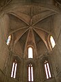 Interior of Santa María la Real Church.
 Façade of Iglesia de Santa María la Real

._Portal_principal.jpg)


Wine caves
 Stairs cut into rock in a wine cave in Aranda de Duero
 Wine storage in a wine cave in Aranda de Duero
 Wine cave in Aranda de Duero
 Wine cave in Aranda de Duero
 Wine cave in Aranda de Duero
 Wine cave in Aranda de Duero


Places of interest
Summarize
Perspective


santa María la Real is a church built by Simon de Colonia during the 15th and 16th centuries. Its most notable feature is the main doorway. Above the doorway, three carved stone reliefs show Christ carrying the Cross, The Crucifixion and The Resurrection. The doorway is topped by the coat of arms of King Ferdinand II of Aragon and Queen Isabella I of Castile. Aranda's own coats of arms is also present along with scenes from the Nativity and other Christian celebrations. Due to their deterioration, the church doors have been replaced by exact copies, the original ones are kept in the Museo Sacro.
San Juan, a church, older than Santa Maria and gothic in style, San Juan still has its fortified defensive tower. The Council of Aranda took place in San Juan in 1473. Nowadays San Juan houses the Museo Sacro.
The Virgen de las Viñas Sanctuary is a 17th-century hermitage. It is situated on a small hill to the north of the town. The patron saint of the town is the Virgen de las Viñas, the local legend says that she was found in a vineyard, hence the name.
The Train museum is situated in the old train station "Chelva" and documents the history of Spanish railways.
The Pottery museum houses pottery from all over Spain, with the largest collection from Castile and León.
The Berdugo's palace is a Renaissance mansion.
Bodegas; under the town centre there is a labyrinth of cellars, they were dug between the 12th and 17th centuries. Their original purpose was to store the food and wine that makes the Ribera del Duero famous. Nowadays the Cellars are home to the "Peñas", cultural associations whose main function is to preserve the cellars, organise social events and ensure the whole of the population enjoy the Fiestas.
San Juan de la Vera Cruz Parish Church.
San Nicolas de Bari is a church in the village of Sinovas.
The Conchuela Bridge.
The Romanesque Bridge is situated next to the San Juan Church.
The Humilladero is a stone monument on the route to Las Viñas Sanctuary.
Isilla street is the main pedestrian thoroughfare of the town. Local tradition has it that anyone living in Aranda will walk along this street every day.
Kikos is a small store in the main square, it offers a wide variety of different lollies, chips, drinks and toys
Twin towns – sister cities


Aranda de Duero is twinned with:[4]
 Langen, Germany
 Miranda do Douro, Portugal
 Romorantin-Lanthenay, France
 Roseburg, United States
- Salon-de-Provence, France
 Santa Cruz de Tenerife, Spain
Notable people
References
Sources and external links
Wikiwand - on
Seamless Wikipedia browsing. On steroids.