Ar-Rutba District
District in Al Anbar Governorate, Iraq From Wikipedia, the free encyclopedia
District in Al Anbar Governorate, Iraq From Wikipedia, the free encyclopedia
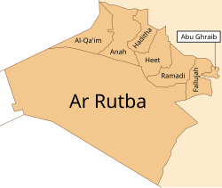
Ar-Rutba District (Arabic: قضاء الرطبة) is the largest district by area in Al Anbar Governorate also the largest in the entirety of Iraq, covering 93,445 km2, and the least populated in relative and absolute terms in Anbar Governorate, with a population of 47,040 or 0.5112 per km2.[1] It is also the southernmost district of Al Anbar Governorate, the westernmost of the whole country, and the only district nationwide bordering Jordan. It is centred on the town of Ar-Rutba.
Ar-Rutba District
قضاء الرطبة | |
|---|---|
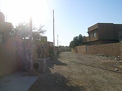
 Street scene in Ar-Rutba town (2004) Ar-Rutba is the largest, southernmost and westernmost of the districts in Al Anbar Governorate | |
 | |
| Coordinates: 33°2′17″N 40°17′4″E | |
| Country | |
| Governorates | Al Anbar Governorate |
| Seat | Ar-Rutba |
| Area | |
| • Total | 93,445 km2 (36,079 sq mi) |
| Population 2018 | |
| • Total | 47,040 |
| • Density | 0.50/km2 (1.3/sq mi) |
| Time zone | UTC+3 (AST) |
Seamless Wikipedia browsing. On steroids.
Every time you click a link to Wikipedia, Wiktionary or Wikiquote in your browser's search results, it will show the modern Wikiwand interface.
Wikiwand extension is a five stars, simple, with minimum permission required to keep your browsing private, safe and transparent.