Loading AI tools
City in Indiana, United States From Wikipedia, the free encyclopedia
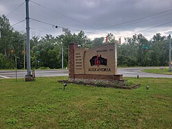
Alexandria is a city in Monroe Township, Madison County, Indiana, United States. It is about 48 miles (77 km) northeast of Indianapolis. According to the 2020 census, its population was 5,149,[3] nearly unchanged from 2010.
Alexandria, Indiana | |
|---|---|
 | |
| Nickname: "Small Town USA" | |
 Location in Madison County, Indiana | |
| Coordinates: 40°15′17″N 85°40′23″W | |
| Country | United States |
| State | Indiana |
| County | Madison |
| Township | Monroe |
| Government | |
| • Mayor | Todd Naselroad (R)[citation needed] |
| Area | |
| • Total | 3.02 sq mi (7.83 km2) |
| • Land | 3.02 sq mi (7.83 km2) |
| • Water | 0.00 sq mi (0.00 km2) |
| Elevation | 869 ft (265 m) |
| Population | |
| • Total | 5,149 |
| • Density | 1,702.15/sq mi (657.25/km2) |
| Time zone | UTC-5 (EST) |
| • Summer (DST) | UTC-4 (EDT) |
| ZIP code | 46001 |
| Area code | 765 |
| FIPS code | 18-00910[4] |
| GNIS feature ID | 2393917[2] |
| Website | www |

Alexandria was platted in 1836, when it was certain that the Indiana Central Canal would be extended to that point.[5] It was incorporated as a town in 1898.[6]
In 1898, Indiana's first Interurban railway line began operating between Alexandria and Anderson.[7]
Alexandria is located in northern Madison County. Indiana State Road 9 passes through the east side of the city, leading south 11 miles (18 km) to Anderson, the county seat, and north 21 miles (34 km) to Marion. State Road 28 crosses the northern tip of Alexandria, leading west 9 miles (14 km) to Elwood and east 23 miles (37 km) to Albany.
According to the U.S. Census Bureau, Alexandria has a total area of 3.0 square miles (7.8 km2), all land.[1] Pipe Creek crosses the city south of its center, flowing southwest to join the White River at Perkinsville.
Alexandria is part of the Indianapolis–Carmel–Anderson metropolitan statistical area.
As of the census[9] of 2010, there were 5,145 people, 2,113 households, and 1,362 families living in the city. The population density was 1,956.3 inhabitants per square mile (755.3/km2). There were 2,507 housing units at an average density of 953.2 per square mile (368.0/km2). The racial makeup of the city was 97.4% White, 0.3% African American, 0.1% Native American, 0.2% Asian, 0.8% from other races, and 1.1% from two or more races. Hispanic or Latino people of any race were 1.7% of the population.
Of the 2,113 households 33.6% had children under the age of 18 living with them, 42.2% were married couples living together, 15.7% had a female householder with no husband present, 6.6% had a male householder with no wife present, and 35.5% were non-families. 30.1% of households were one person and 12.8% were one person aged 65 or older. The average household size was 2.41 and the average family size was 2.95.
The median age was 38.2 years. 25.6% of residents were under the age of 18; 8.8% were between the ages of 18 and 24; 24.8% were from 25 to 44; 25.1% were from 45 to 64; and 15.6% were 65 or older. The gender makeup of the city was 47.8% male and 52.2% female.
As of the census[4] of 2000, there were 6,260 people, 2,481 households, and 1,654 families living in the city. The population density was 2,308.6 inhabitants per square mile (891.4/km2). There were 2,704 housing units at an average density of 997.2 per square mile (385.0/km2). The racial makeup of the city was 98.10% White, 0.46% Black or African American, 0.08% Native American, 0.11% Asian, 0.02% Pacific Islander, 0.43% from other races, and 0.80% from two or more races. 0.99% of the population were Hispanic or Latino of any race.
Of the 2,481 households 33.9% had children under the age of 18 living with them, 49.0% were married couples living together, 12.7% had a female householder with no husband present, and 33.3% were non-families. 28.9% of households were one person and 13.1% were one person aged 65 or older. The average household size was 2.48 and the average family size was 3.04.
The age distribution was 27.8% under the age of 18, 8.9% from 18 to 24, 28.0% from 25 to 44, 19.5% from 45 to 64, and 15.9% 65 or older. The median age was 35 years. For every 100 females, there were 91.4 males. For every 100 females age 18 and over, there were 87.4 males.
The median household income was $35,359 and the median family income was $42,731. Males had a median income of $30,529 versus $23,384 for females. The per capita income for the city was $15,578. About 4.2% of families and 7.0% of the population were below the poverty line, including 4.1% of those under age 18 and 15.0% of those age 65 or over.
The city council consists of seven members. Five members are elected from individual districts, and two are elected at large. The city is governed by a "strong" mayor system that appoints two council members and/or city residents to serve at the mayor's pleasure on the board of public works and safety. The chief financial officer is the clerk-treasurer. The clerk-treasurer and mayor are full-time elected officials.
Alexandria Airport is a public use airport located 3 miles (5 km) southeast of the central business district of Alexandria.[10]
Alexandria Community School Corporation operates the public schools.
The town has a lending library, the Alexandria-Monroe Public Library.[11]
Seamless Wikipedia browsing. On steroids.
Every time you click a link to Wikipedia, Wiktionary or Wikiquote in your browser's search results, it will show the modern Wikiwand interface.
Wikiwand extension is a five stars, simple, with minimum permission required to keep your browsing private, safe and transparent.