Top Qs
Timeline
Chat
Perspective
Aerial survey
Method of collecting geophysical data from high altitude aircraft From Wikipedia, the free encyclopedia
Remove ads
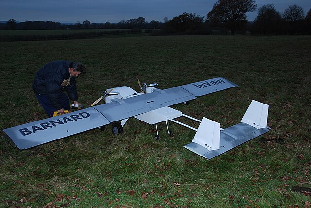
Aerial survey is a method of collecting geomatics or other imagery data using airplanes, helicopters, UAVs, balloons, or other aerial methods. Typical data collected includes aerial photography, Lidar, remote sensing (using various visible and invisible bands of the electromagnetic spectrum, such as infrared, gamma, or ultraviolet) and geophysical data (such as aeromagnetic surveys and gravity measurements). It can also refer to a chart or map made by analyzing a region from the air. Aerial survey should be distinguished from satellite imagery technologies because of its better resolution, quality, and resistance to atmospheric conditions that can negatively impact and obscure satellite observation. Today, aerial survey is often recognized as a synonym for aerophotogrammetry, a part of photogrammetry where the camera is airborne. Measurements on aerial images are provided by photogrammetric technologies and methods.[1]


Aerial surveys can provide information on many things not visible from the ground.
Remove ads
Terms used in aerial survey
- exposure station or air station
- the position of the optical center of the camera at the moment of exposure.
- flying height
- the elevation of the exposure station above the datum (usually mean sea level).
- altitude
- the vertical distance of the aircraft above the Earth's surface.
- tilt the angle between the aerial camera and the horizontal axis perpendicular to the line of flight.
- tip
- the angle between the aerial camera and the line of flight.
- principal point
- the point of intersection of the optical axis of the aerial camera with the photographical plane.
- isocentre
- the point on the aerial photograph in which the bisector of the angle of tilt meets the photograph.
- nadir point
- the image of the nadir, i.e. the point on the aerial photograph where a plumbline dropped from the front nodal point pierces the photograph.
- scale
- ratio of the focal length of the camera objective and the distance of the exposure station from the ground.
- azimuth
- the clockwise horizontal angle measured about the ground nadir point from the ground survey North meridian in the plane of photograph.
- orthomosaic
- A high-resolution map created by orthophotos, usually via drones is termed as an orthomosaic. Ortho meaning a nadir image and mosaic meaning a collection of images.
- Temporal Resolution
- Time between observations.
Remove ads
Uses
Aerial surveys are used for:

- Archaeology
- Fishery surveys
- Geophysics in geophysical surveys
- Hydrocarbon exploration
- Land survey
- Mining and mineral exploration
- Monitoring wildlife and insect populations (called aerial census or sampling)
- Monitoring vegetation and ground cover
- Reconnaissance
- Transportation projects in conjunction with ground surveys (roadway, bridge, highway)
Aerial surveys use a measuring camera where the elements of its interior orientation are known, but with much larger focal length and film and specialized lenses.
Remove ads
Aerial survey sensors
In order to carry out an aerial survey, a sensor needs to be fixed to the interior or exterior of the airborne platform with line-of-sight to the target; it is remotely sensing. With manned aircraft, this is accomplished either through an aperture in the skin of the aircraft or mounted externally on a wing strut. With unmanned aerial vehicles (UAVs), sensors are often mounted under or inside the vehicle, allowing for rapid data collection over challenging terrains, though sometimes with less precision than traditional methods.[3]
Aerial survey systems typically include the following components:
- Flight navigation software to guide the pilot in flying the desired survey pattern.
- GNSS, combining GPS and an inertial measurement unit (IMU) to provide accurate position and orientation data.
- Gyro-stabilized mounts to counteract the effects of aircraft roll, pitch, and yaw.
- Data storage units to securely save the recorded data.
Examples of aerial survey sensors
See also
References
External links
Wikiwand - on
Seamless Wikipedia browsing. On steroids.
Remove ads
