File:Great_Schism_1054_with_former_borders.png
From Wikipedia, the free encyclopedia
Μέγεθος αυτής της προεπισκόπησης: 560 × 599 εικονοστοιχεία . Άλλες αναλύσεις: 224 × 240 εικονοστοιχεία | 448 × 480 εικονοστοιχεία | 717 × 768 εικονοστοιχεία | 957 × 1.024 εικονοστοιχεία | 2.000 × 2.141 εικονοστοιχεία.
Εικόνα σε υψηλότερη ανάλυση (2.000 × 2.141 εικονοστοιχεία, μέγεθος αρχείου: 420 KB, τύπος MIME: image/png)
|
|
Αυτό το αρχείο και η περιγραφή του προέρχονται από το Wikimedia Commons. Οι πληροφορίες από την σελίδα περιγραφής του εκεί εμφανίζονται παρακάτω. |
| The factual accuracy of this map is disputed. See File talk:Great Schism 1054 with former borders.png#Numerous problems, map is unreliable. |

|
This religion map image could be re-created using vector graphics as an SVG file. This has several advantages; see Commons:Media for cleanup for more information. If an SVG form of this image is available, please upload it and afterwards replace this template with
{{vector version available|new image name}}.
It is recommended to name the SVG file “Great Schism 1054 with former borders.svg”—then the template Vector version available (or Vva) does not need the new image name parameter. |
Σύνοψη
| ΠεριγραφήGreat Schism 1054 with former borders.png |
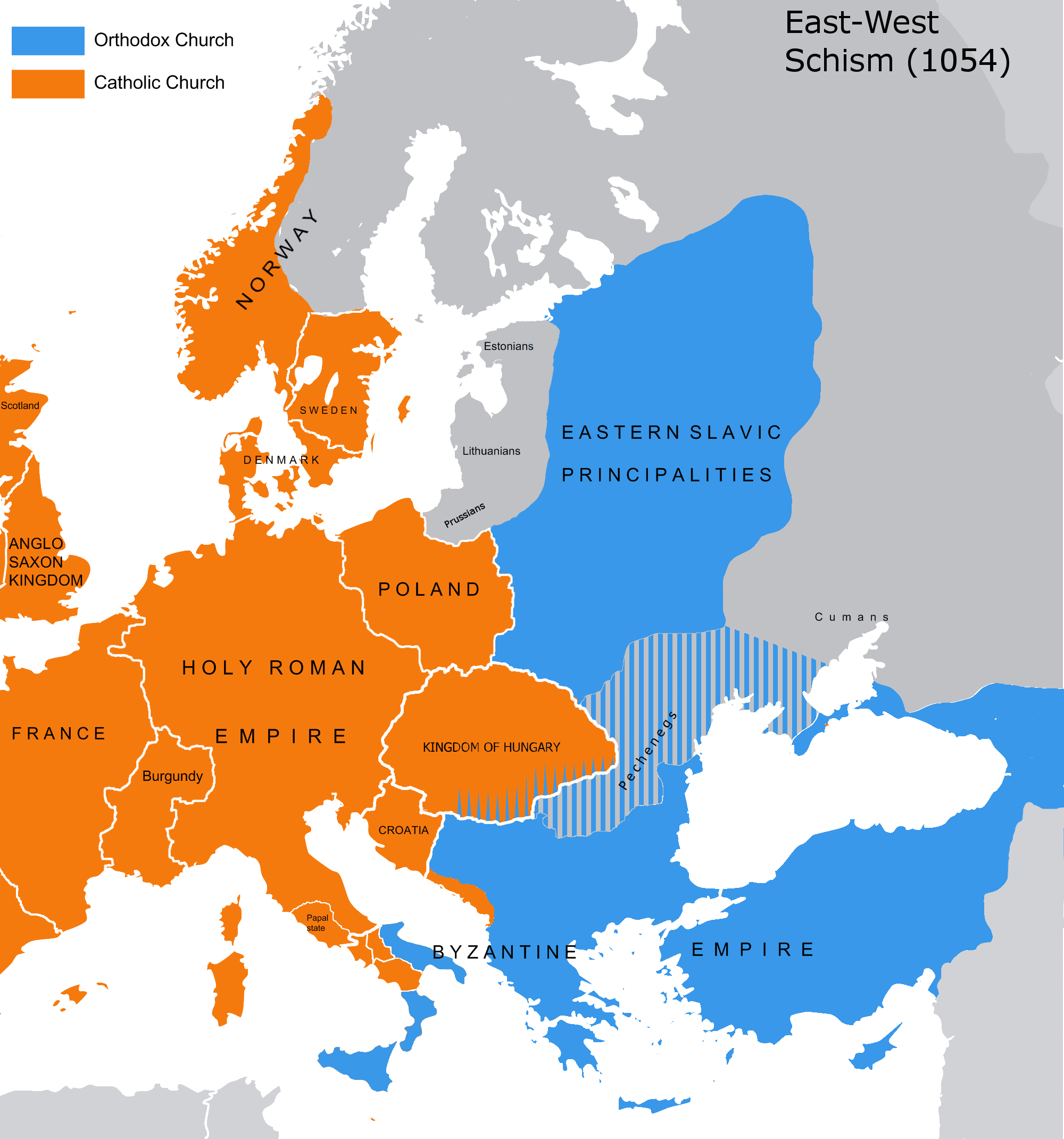
English: The map of the eastern/western allegiances in 1054 with the former country borders.
Español: El mapa de las creencias en el este/oeste en 1054 con las fronteras del país anterior. Los puntos representan concentraciones de minorías y no ubicaciones específicas. Las líneas rayadas representan cohabitaciones religiosas y no mayorías (que están representadas por colores sólidos).
Deutsch: Karte über das Morgenländische Schisma mit den ehemaligen Landesgrenzen. Die schraffierten Linien stellen religiöse Zusammenleben und keine Mehrheiten dar (die durch Vollfarben dargestellt werden).
Magyar: A nagy kelet-nyugati egyházszakadás térképe az 1054-nek megfelelő határokkal. A pontok a kisebbségek koncentrációját jelölik, nem pedig meghatározott helyeket. A sraffozott vonalak a vallási együttéléseket jelölik, nem pedig a többséget (amelyeket egyszínű színek jelölnek). |
|||
| Ημερομηνία | 04.09.2010. | |||
| Πηγή | Source: Westermanns Atlas zur Weltgeschichte, 1957, p. 64-5, maps titled "Staaten u. Bekenntnisse im Mittelmeerraum nach den ersten Kreuzzügen (um 1190)" (p. 64) and "Mittelmeerwelt und Vorderasien vor Beginn der Kreuzzüge (1096)" (p. 65) and Alexander Kazhdan (dir.), Oxford Dictionary of Byzantium, Oxford University Press, 1991, 1re éd., 3 tom. (ISBN 978-0-19-504652-6, LCCN 90023208), art. « Patriarchates », vol. 3, pp. 1599-1600. | |||
| Δημιουργός | Tobi85 | |||
| Άδεια (Επαναχρησιμοποίηση αυτού του αρχείου) |
|
|||
| άλλες εκδόσεις | Derivative works of this file: Great Schism 1054 with former borders-ar.png |
Αδειοδότηση
| Public domainPublic domainfalsefalse |
| Εγώ, ο κάτοχος των πνευματικών δικαιωμάτων αυτού του έργου, δημοσιεύω αυτό το έργο ως κοινό κτήμα. Αυτό ισχύει σε παγκόσμια κλίμακα. Σε ορισμένες χώρες αυτό μπορεί να μην είναι νομικά εφικτό. Αν ναι: Παραχωρώ σε οποιονδήποτε το δικαίωμα να χρησιμοποιήσει αυτό το έργο "για οποιονδήποτε σκοπό", χωρίς κανέναν όρο, εκτός και αν τέτοιοι όροι τίθενται από την νομοθεσία |
_en.png)
.png)
.jpg)
Λεζάντες
Δεν ορίστηκε λεζάντα
Items portrayed in this file
απεικονίζει
image/png
Ιστορικό αρχείου
Κλικάρετε σε μια ημερομηνία/ώρα για να δείτε το αρχείο όπως εμφανιζόταν εκείνη τη στιγμή.
| Ώρα/Ημερομ. | Μικρογραφία | Διαστάσεις | Χρήστης | Σχόλια | |
|---|---|---|---|---|---|
| τελευταία | 13:16, 9 Ιουλίου 2023 | | 2.000 × 2.141 (420 KB) | Veverve | Reverted to version as of 21:25, 11 November 2022 (UTC): this is a huge extrapolation to make based solely on the fact that there were some Byzantine churches in Hungary |
| 15:01, 19 Μαρτίου 2023 |  | 2.000 × 2.141 (439 KB) | Moodylo333 | Reverted to 8 November 2017 according with Dora Wiebenson, József Sisa, Pál Lövei, "The architecture of historic Hungary" (p. 11) who admit the presence of byzantine churches in Eastern Hungary. | |
| 21:25, 11 Νοεμβρίου 2022 |  | 2.000 × 2.141 (420 KB) | Gyalu22 | As Veverve said, no personal opinions should be used. The previous status in Hungary was drawn by Cepleanu who referred to the Westermanns Atlas in the talk page. But that atlas shows the situation very differently. | |
| 19:58, 23 Οκτωβρίου 2022 |  | 2.000 × 2.141 (479 KB) | Veverve | Reverted to version as of 11:04, 1 June 2022 (UTC) original research and personnal opinions should no be used | |
| 19:12, 23 Οκτωβρίου 2022 |  | 2.000 × 2.141 (492 KB) | Gyalu22 | Religion was not an ethnic question. Transylvania was a religiously diverse region, but Catholicism was already dominant to Alba Iulia | |
| 11:04, 1 Ιουνίου 2022 |  | 2.000 × 2.141 (479 KB) | Moodylo333 | Reliable version with Alexander Kazhdan (dir.), Oxford Dictionary of Byzantium, New York et Oxford, Oxford University Press, 1991, 1re éd., 3 tom. (ISBN 978-0-19-504652-6 et 0-19-504652-8, LCCN 90023208), 1991, art. « Patriarchates », vol. 3, pp. 1599-1600. | |
| 13:51, 1 Φεβρουαρίου 2022 |  | 2.000 × 2.141 (488 KB) | Moodylo333 | Reverted to version as of 20:17, 8 July 2018 (UTC) without Bogomils (off topic) | |
| 13:49, 1 Φεβρουαρίου 2022 |  | 2.000 × 2.141 (488 KB) | Moodylo333 | Reverted to version as of 20:15, 8 July 2018 (UTC) : COM:CROP | |
| 09:41, 26 Νοεμβρίου 2021 |  | 2.000 × 2.141 (420 KB) | Veverve | Reverted to version as of 15:53, 26 October 2011 (UTC) revert to version closer to the Westermanns Atlas zur Weltgeschichte, see File_talk:Great_Schism_1054_with_former_borders.png#Numerous_problems,_map_is_unreliable | |
| 23:18, 29 Μαΐου 2021 |  | 2.000 × 2.141 (494 KB) | Ceha | Catholic-ortodox borders in the southeast |
Συνδέσεις αρχείου
Δεν υπάρχουν σελίδες που συνδέουν σε αυτό το αρχείο.
Καθολική χρήση αρχείου
Τα ακόλουθα άλλα wiki χρησιμοποιούν αυτό το αρχείο:
- Χρήση σε ar.wikipedia.org
- Χρήση σε ca.wikipedia.org
- Χρήση σε cs.wikipedia.org
- Χρήση σε de.wikipedia.org
- Χρήση σε de.wikibooks.org
- Χρήση σε en.wikipedia.org
- Χρήση σε fr.wikipedia.org
- Χρήση σε ga.wikipedia.org
- Χρήση σε hu.wikipedia.org
- Χρήση σε ro.wikipedia.org
- Χρήση σε www.wikidata.org
Μεταδεδομένα
Αυτό το αρχείο περιέχει πρόσθετες πληροφορίες, πιθανόν από την ψηφιακή φωτογραφική μηχανή ή το scanner που χρησιμοποιήθηκε για την δημιουργία ή την ψηφιοποίησή της. Αν το αρχείο έχει τροποποιηθεί από την αρχική του κατάσταση, ορισμένες λεπτομέρειες πιθανόν να μην αντιστοιχούν πλήρως στην τροποποιημένη εικόνα.
| Οριζόντια ανάλυση | 28,35 dpc |
|---|---|
| Κατακόρυφη ανάλυση | 28,35 dpc |