Armagh (District)
nordirischer District Aus Wikipedia, der freien Enzyklopädie
nordirischer District Aus Wikipedia, der freien Enzyklopädie
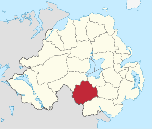
Armagh (irisch: Ard Mhacha) war einer der 26 nordirischen Districts, die von 1973 bis 2015 bestanden. Der District, dessen Gebiet in der traditionellen Grafschaft Armagh lag, wurde 1973 eingerichtet. Er lag an der nordirischen Südgrenze und umfasste die Stadt Armagh, die auch Verwaltungssitz war, mit ihrem Umland. Zum 1. April 2015 ging er im neuen District Armagh, Banbridge and Craigavon auf.
| Armagh District Ceantar Ard Mhacha | |
|---|---|
 | |
| Geografie | |
| Traditionelle Grafschaft | County Armagh |
| Fläche | 671 km² |
| Verwaltungssitz | Armagh |
| ISO 3166-2 | GB-ARM |
| Demografie | |
| Bevölkerung | 60.147 (2012)[1] |
| Dichte | 90 Ew./km² |
| Konfessionen | Protestanten 43,0 % Katholiken 44,8 %[2] |
Die Wahl zum Armagh City and District Council am 11. Mai 2011 hatte folgendes Ergebnis:[3]
| Partei | Ergebnis 2011 | Veränderung zu 2005 | |||
|---|---|---|---|---|---|
| Sitze | Stimmen | Sitze | Stimmen | ||
| Ulster Unionist Party (UUP) | 6 | 27,6 % | 1 | 4,9 % | |
| Sinn Féin | 6 | 24,8 % | 1 | 1,7 % | |
| Social Democratic and Labour Party (SDLP) | 5 | 21,3 % | −1 | 0,2 % | |
| Democratic Unionist Party (DUP) | 4 | 21,1 % | −2 | −8,4 % | |
| Traditional Unionist Voice | 0 | 0,6 % | 0 | 0,6 % | |
| Unabhängige | 1 | 4,5 % | 1 | 1,1 % | |
Seamless Wikipedia browsing. On steroids.
Every time you click a link to Wikipedia, Wiktionary or Wikiquote in your browser's search results, it will show the modern Wikiwand interface.
Wikiwand extension is a five stars, simple, with minimum permission required to keep your browsing private, safe and transparent.