Loading AI tools
Landkreis in der Provinz Lampang, Thailand Aus Wikipedia, der freien Enzyklopädie
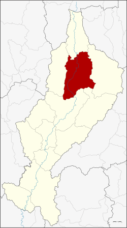
Amphoe Chae Hom (Thai อำเภอ แจ้ห่ม, Aussprache: ) ist ein Landkreis (Amphoe – Verwaltungs-Distrikt) im Norden der Provinz Lampang. Die Provinz Lampang liegt in der Nordregion von Thailand.
| Chae Hom แจ้ห่ม | |
|---|---|
| Provinz: | Lampang |
| Fläche: | 1349,121 km² |
| Einwohner: | 40.575 (2013) |
| Bev.dichte: | 31,5 E./km² |
| PLZ: | 52120 |
| Geocode: | 5206 |
| Karte | |
 | |

Benachbarte Landkreise (von Norden im Uhrzeigersinn): die Amphoe Wang Nuea, Ngao, Mae Mo, Mueang Lampang und Mueang Pan der Provinz Lampang.
Der Chae-Son-Nationalpark (Thai: อุทยานแห่งชาติแจ้ซ้อน) liegt zum Teil im Landkreis Chae Hom.
Durch den Landkreis fließt der Mae Nam Wang (Wang-Fluss).
Der Landkreis Chae Hom ist in sieben Tambon („Unterbezirke“ oder „Gemeinden“) eingeteilt, die sich weiter in 64 Muban („Dörfer“) unterteilen.
| Nr. | Name | Thai | Muban | Einw.[1] |
|---|---|---|---|---|
| 1. | Chae Hom | แจ้ห่ม | 11 | 8.205 |
| 2. | Ban Sa | บ้านสา | 10 | 5.090 |
| 3. | Pong Don | ปงดอน | 8 | 4.842 |
| 4. | Mae Suk | แม่สุก | 12 | 7.187 |
| 5. | Mueang Mai | เมืองมาย | 6 | 3.346 |
| 6. | Thung Phueng | ทุ่งผึ้ง | 6 | 4.056 |
| 7. | Wichet Nakhon | วิเชตนคร | 11 | 7.849 |
Es gibt drei Kommunen mit „Kleinstadt“-Status (Thesaban Tambon) im Landkreis:
Außerdem gibt es fünf „Tambon-Verwaltungsorganisationen“ (องค์การบริหารส่วนตำบล – Tambon Administrative Organizations, TAO)
Seamless Wikipedia browsing. On steroids.
Every time you click a link to Wikipedia, Wiktionary or Wikiquote in your browser's search results, it will show the modern Wikiwand interface.
Wikiwand extension is a five stars, simple, with minimum permission required to keep your browsing private, safe and transparent.