Abai (Gebiet)
Gebiet in Kasachstan Aus Wikipedia, der freien Enzyklopädie
Gebiet in Kasachstan Aus Wikipedia, der freien Enzyklopädie
Das Gebiet Abai (kasachisch Абай облысы Abai oblyssy, russisch Абайская область Abaiskaja Oblast) ist ein Oblys im Osten Kasachstans. Es entstand 2022 durch die Abspaltung von Ostkasachstan und hat 610.189 Einwohner (Stand: 1. Januar 2023).
| Gebiet Abai Абай облысы Абайская область | |
| Basisdaten | |
|---|---|
| Staat: | Kasachstan |
| Verwaltungssitz: | Semei |
| Gegründet: | 8. Juni 2022 |
| Koordinaten: | 49° 0′ N, 80° 0′ O |
| Einwohner: | 610.189 (1. Jan. 2023)[1] |
| Fläche: | 185.476 km² |
| Bevölkerungsdichte: | 3 Einwohner je km² |
| Postleitzahlen: | |
| Kfz-Kennzeichen: | 18 |
| KATO-Code: | 100000000 |
| ISO 3166-2: | KZ-10 |
| Äkim (Gouverneur): | Nurlan Uranchajew[2] |
| Webpräsenz: | |
| Lage in Kasachstan | |
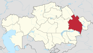 | |
Das Gebiet wurde am 8. Juni 2022 geschaffen, indem Teile des Gebiets Ostkasachstan aus diesem ausgegliedert wurden.[2] Das Territorium entspricht in etwa dem des früheren Gebiets Semipalatinsk.
Das Gebiet ist in zehn Bezirke (kasachisch Аудан Audan; russisch Район Rajon) unterteilt. Zusätzlich stellen die Städte Kurtschatow und Semei jeweils einen eigenen städtischen Bezirk dar.

| Audan | Einwohner | Verwaltungssitz |
|---|---|---|
| Abai | 14.058 | Qarauyl |
| Ajagös | 66.239 | Ajagös |
| Aqsuat | 19.735 | Aqsuat |
| Besqaraghai | 17.863 | Besqaraghai |
| Borodulicha | 33.241 | Borodulicha |
| Kökpekti | 13.636 | Kökpekti |
| Kurtschatow (Stadt) | 10.457 | Kurtschatow |
| Maqanschy | Maqanschy | |
| Semei (Stadt) | 328.762 | Semei |
| Schangassemei | Semei | |
| Scharma | 36.518 | Kalbatau |
| Ürschar | 69.680 | Ürschar |
| Stand: 1. Januar 2023[3] | ||
Seamless Wikipedia browsing. On steroids.
Every time you click a link to Wikipedia, Wiktionary or Wikiquote in your browser's search results, it will show the modern Wikiwand interface.
Wikiwand extension is a five stars, simple, with minimum permission required to keep your browsing private, safe and transparent.
