Delwedd:Brittain_410.jpg
From Wikipedia, the free encyclopedia
Maint llawn ((1,111 × 1,497 picsel, maint y ffeil: 369 KB, ffurf MIME: image/jpeg))
Daw'r ffeil hon o Comin Wikimedia a gellir ei defnyddio gan brosiectau eraill. Dangosir isod y disgrifiad sydd ar dudalen ddisgrifio'r ffeil yno.
Crynodeb
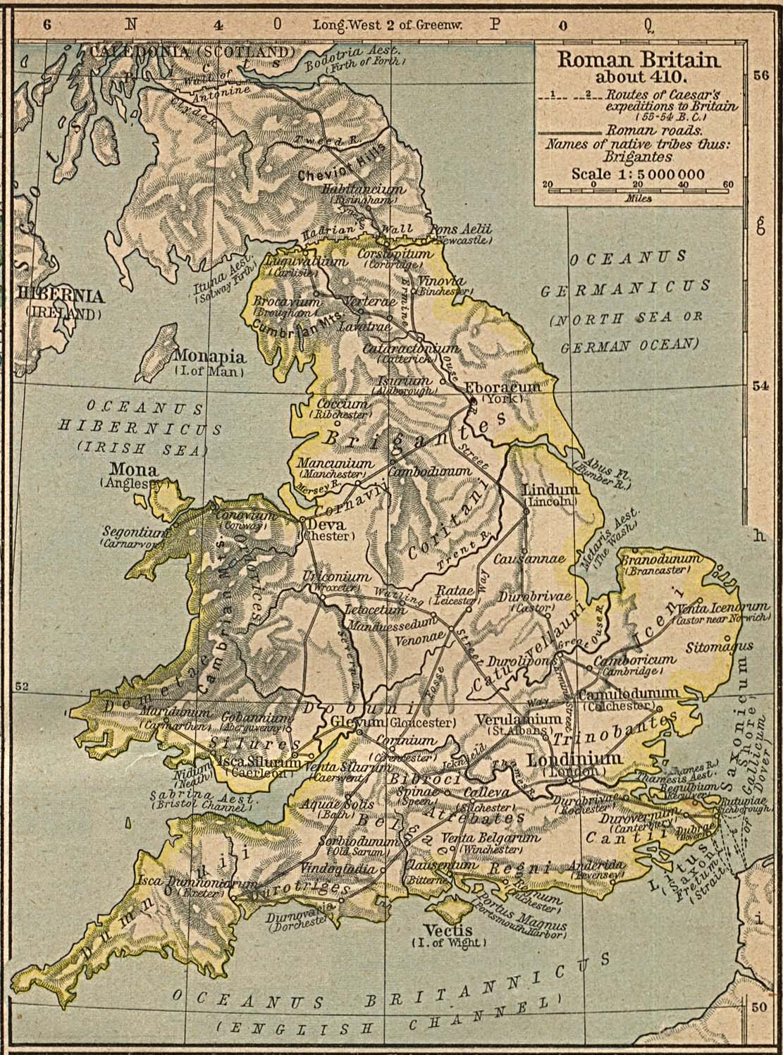
Map of the isle Great Britain in the year 410. Image comes from the Historical Maps of Europe at University of Texas at Austin The work is from From The Historical Atlas by William R. Shepherd, 1926.
Map is released into the public Domain.
Trwyddedu
| Public domainPublic domainfalsefalse |
|
This work is in the public domain in its country of origin and other countries and areas where the copyright term is the author's life plus 70 years or fewer.
| |
| Canfyddwyd bod y ffeil yn rhydd o gyfyngiadau yn ôl cyfraith hawlfraint, gan gynnwys pob hawl perthynol a chyfagos. | |
https://creativecommons.org/publicdomain/mark/1.0/PDMCreative Commons Public Domain Mark 1.0falsefalse
Captions
Items portrayed in this file
yn portreadu
media type Saesneg
image/jpeg
checksum Saesneg
5325c2bab0aea4c66586a9b7574d59111b6a28ef
data size Saesneg
378,105 byte
1,497 pixel
1,111 pixel
Hanes y ffeil
Cliciwch ar ddyddiad / amser i weld y ffeil fel ag yr oedd bryd hynny.
| Dyddiad / Amser | Bawdlun | Hyd a lled | Defnyddiwr | Sylw | |
|---|---|---|---|---|---|
| cyfredol | 15:24, 3 Rhagfyr 2005 | | 1,111 × 1,497 (369 KB) | Migdejong | Map of the isle Great Brittain in the year 410. Image comes from the University of Texas at Austin: http://geography.about.com/gi/dynamic/offsite.htm?site=http://www.lib.utexas.edu/maps/historical/history%5Feurope.html Map is released into the publi |
Cysylltiadau'r ffeil
Mae'r 1 tudalennau a ddefnyddir isod yn cysylltu i'r ddelwedd hon:
Defnydd cydwici y ffeil
Mae'r wicis eraill hyn yn defnyddio'r ffeil hon:
- Y defnydd ar ar.wikipedia.org
- Y defnydd ar arz.wikipedia.org
- Y defnydd ar azb.wikipedia.org
- Y defnydd ar bn.wikipedia.org
- Y defnydd ar br.wikipedia.org
- Y defnydd ar ca.wikipedia.org
- Y defnydd ar el.wikipedia.org
- Y defnydd ar en.wikipedia.org
- Y defnydd ar es.wikipedia.org
- Y defnydd ar et.wikipedia.org
- Y defnydd ar fr.wikipedia.org
- Y defnydd ar hr.wikipedia.org
- Y defnydd ar hu.wikipedia.org
- Y defnydd ar hy.wikipedia.org
- Y defnydd ar is.wikipedia.org
- Y defnydd ar it.wikipedia.org
- Y defnydd ar lt.wikipedia.org
- Y defnydd ar pl.wikipedia.org
- Y defnydd ar ru.wikipedia.org
- Y defnydd ar sh.wikipedia.org
- Y defnydd ar sl.wikipedia.org
- Y defnydd ar sr.wikipedia.org
- Y defnydd ar zh.wikipedia.org
Metadata
Mae'r ffeil hon yn cynnwys gwybodaeth ychwanegol, sydd mwy na thebyg wedi dod o'r camera digidol neu'r sganiwr a ddefnyddiwyd i greu'r ffeil neu ei digido. Os yw'r ffeil wedi ei cael ei newid ers ei chreu efallai nad yw'r manylion hyn yn dal i fod yn gywir.
| _error | 0 |
|---|