Ӳкерчĕк:Wostok-Station_core32.jpg
From Wikipedia, the free encyclopedia
Оригиналлӑ файл ((1000 × 644 пиксел, файл пысăкăше: 89 КБ, MIME-тĕсĕ: image/jpeg))
Ку файлпа, на Викискладе илнӗскерпе, ытти проектсенче усӑ курма пултараҫҫӗ. Унӑн страницӑри ӑнлантарӑвӗпе аяларах паллаштарнӑ.
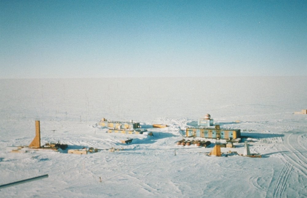
| ӐнлантарниWostok-Station core32.jpg | Wostok-Station (NOAA), photo by Todd Sowers, Lamont-Doherty Earth Observatory (LDEO), Columbia University, Palisades, New York, for NOAA. The Vostok site was chosen by the Soviet Union for the deep coring possibilities it offered. French and, later, American scientists became interested in the Soviet research and began to participate in coring activities at the site. This panoramic photo of Vostok Station shows the layout of the camp. The striped building on the left is the power station while the striped building on the right is where researchers sleep and take meals. The building in the background with the red- and white-striped ball on top is the meteorology building. Caves were dug into the ice sheet for storage, keeping cores at an ideal -55 degrees C year round. | ||||
| Дата | (date attribute of the source file) | ||||
| Ҫӑлкуҫ | http://www.ngdc.noaa.gov/paleo/slides/slideset/15/15_300_slide.html | ||||
| Автор | Todd Sowers, Lamont-Doherty Earth Observatory (LDEO), Columbia University, Palisades, New York for NOAA | ||||
| Ирӗклӗхсем (Ку файлпа тепре усӑ курни) |
|
| Местоположение камеры | 78° 27′ 52″ ю. ш., 106° 50′ 50″ в. д. | Это и другие изображения по их местоположению на OpenStreetMap |
|---|
Исходный журнал загрузок
(All user names refer to de.wikipedia)
- 2004-07-02 17:33 Srbauer 768×494×8 (45575 bytes) Wostok-Station (NOAA)
taken from de.wikipedia; description page is/was here. Original uploader was Srbauer at de.wikipedia
Краткие подписи
Элементы, изображённые на этом файле
изображённый объект вырӑс
11 Юпа уйӑхӗн 2001
координаты точки обзора вырӑс
78°27'51.998"S, 106°50'49.999"E
MIME-тип вырӑс
image/jpeg
Файл историйĕ
Вӑхӑт ҫине пуссан, ун чухнехи версине пӑхма пулать.
| Дата/Вăхăт | Миниатюра | Калӑпӑш | Хутшăнакан | Асăрхав | |
|---|---|---|---|---|---|
| хальхи | 20:21, 5 Ака уйӑхӗн 2007 | | 1000 × 644 (89 КБ) | Raul6 | |
| 12:16, 4 Нарӑс уйӑхӗн 2007 |  | 768 × 494 (45 КБ) | Hardscarf | {{Information |Description=Wostok-Station (NOAA) Quelle: http://www.ngdc.noaa.gov/paleo/slides/slideset/15/15_300_slide.html Lizenz: PD Beschreibung: Vostok Site The Vostok site was chosen by the Soviet Union for the deep coring possibilities it offer |
Файлпа усă курни
Ку файлпа ҫак 1 страницӑра усӑ курнӑ:
Файлпа глобаллӑ усӑ курасси
Ку файлпа ҫак викисенче усӑ курнӑ:
- ar.wikipedia.org усӑ курасси
- ast.wikipedia.org усӑ курасси
- az.wikipedia.org усӑ курасси
- be-tarask.wikipedia.org усӑ курасси
- be.wikipedia.org усӑ курасси
- bg.wikipedia.org усӑ курасси
- bs.wikipedia.org усӑ курасси
- ca.wikipedia.org усӑ курасси
- ceb.wikipedia.org усӑ курасси
- cs.wikipedia.org усӑ курасси
- de.wikipedia.org усӑ курасси
- en.wikipedia.org усӑ курасси
- es.wikipedia.org усӑ курасси
- es.wikivoyage.org усӑ курасси
- et.wikipedia.org усӑ курасси
- eu.wikipedia.org усӑ курасси
- fa.wikipedia.org усӑ курасси
- fi.wikipedia.org усӑ курасси
- fr.wikipedia.org усӑ курасси
- he.wikipedia.org усӑ курасси
- hu.wikipedia.org усӑ курасси
- hy.wikipedia.org усӑ курасси
- id.wikipedia.org усӑ курасси
- incubator.wikimedia.org усӑ курасси
Ку файлпа глобальлӗ епле усӑ курнине пӑх.
Метаданнăйсем:
Файлта цифра камерӑсем е сканерсем хушакан хушма даннӑйсем пур. Хатӗрленӗ хыҫҫӑн файла редакциленӗ пулсан хӑш-пӗр параметрсем хальхи сӑнрипе пӗр килмесӗр пултараҫҫӗ.
| Примечание JPEG-файла | The Vostok site was chosen by the Soviet Union for the deep coring possibilities it offered. French and, later, American scientists became interested in the Soviet research and began to participate in coring activities at the site. This panoramic photo of Vostok Station shows the layout of the camp. The striped building on the left is the power station while the striped building on the right is where researchers sleep and take meals. The building in the background with the red- and white-striped ball on top is the meteorology building. Caves were dug into the ice sheet for storage, keeping cores at an ideal -55 degrees C year round. |
|---|