پەڕگە:Caspian_Sea_from_orbit.jpg
From Wikipedia, the free encyclopedia
پەڕگەی سەرەکی (٤٬٤٠٠ × ٥٬٦٠٠ پیکسڵ، قەبارەی پەڕگە: ٣٫٤٤ مێگابایت، جۆری ئێم ئای ئێم ئی: image/jpeg)
ئەم پەڕگە لە Wikimedia Commonsەوەیە و لەوانەیە لە پڕۆژەکانی دیکەش بەکار ھاتبێت. پێناسەکەی لەسەر پەڕەی وەسفی پەڕگەکە لە خوارەوە نیشان دراوە.
کورتە
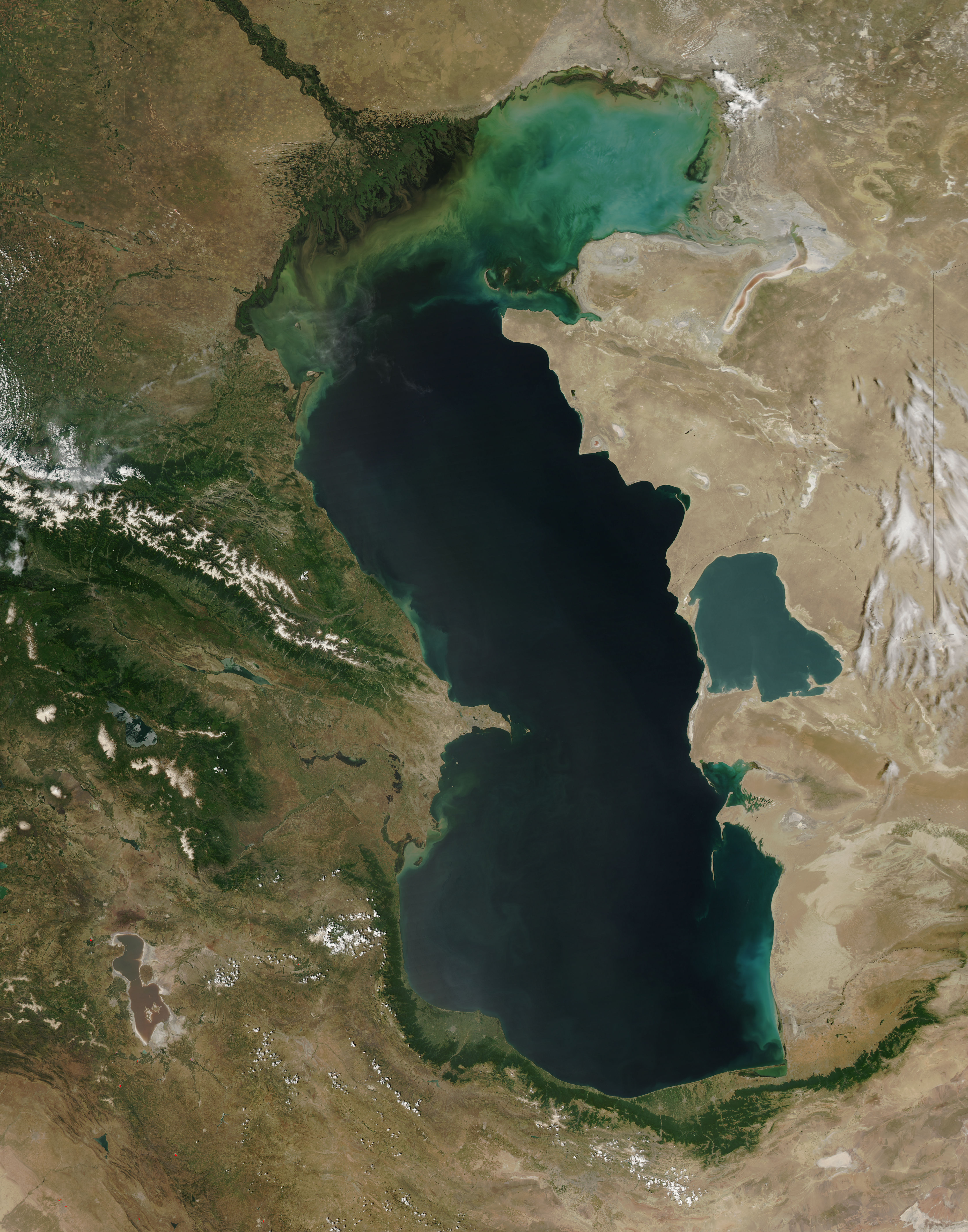
| وەسفCaspian Sea from orbit.jpg |
العربية: منظرٌ من مدار الأرض لِبحر قزوين. التعليق الأصلي: كما أوردته وكالة الناسا: ::"القسم الشمالي من بحر قزوين يُعاني من ظاهرةٍ تُعرف باسم التخثث أو إغناء الماء، وهي تلك الحالة التي تتسببُ فيها الأسمدة الزراعيَّة المُنسابة من خِلال مياه الري والأمطار بِنُمو الطحالب في المياه. يُؤدي نُفوق وتحلُّل تلك الطحالب إلى حرمان المياه من الأكسجين، ممَّا يُؤدي بِدوره إلى الإضرار بِالحياة البريَّة بِطبيعة الحال. هذه الصُورة لِبحر قزوين تُظهرُ بعض الدوَّامات الخضراء والزرقاء على مقرُبةٍ من مصب نهر الڤولغا (أعلى الوسط)، ممَّا يدُل على وُجود كميَّةٍ من الطحالب. اللون الأزرق اللامع في القسم الشمالي الشرقي من البحر قد يكون تولَّد نتيجة اختلاط بعض النباتات بِالترسُبات، نظرًا لِأنَّ هذا الموقع هو أكثر المناطق ضُحولةً في البحر.
English: This is a view from orbit of the Caspian Sea as imaged by the MODIS sensor on the Terra satellite. Caption: The original caption from NASA: ::"The northern part of the Caspian Sea is plagued by a process called eutrophication, in which agricultural run-off rich in fertilizers stimulates rampant growth of algae in the water. The death and decay of these algae robs the water of oxygen, with obvious negative consequences for aquatic life. This image of the Caspian Sea shows swirls of green and blue near the mouth of the Volga River (top center), which indicate the presence of algae. The bright blue color of the northeastern part of the sea may be due to a mixture of plant life and sediment, for this is where the sea is most shallow. This image is from the Moderate Resolution Imaging Spectroradiometer (MODIS) on the Terra satellite on June 11, 2003.
Español: El Mar Caspio visto desde la órbita terrestre
فارسی: تصویر ماهوارهای از دریای خزر
Тоҷикӣ: Тасвири Баҳр Каспӣ аз осмон |
| ڕێکەوت | |
| سەرچاوە |
http://visibleearth.nasa.gov/view_rec.php?id=5514
|
| بەرھەمھێنەر | Jeff Schmaltz, MODIS Rapid Response Team, NASA/GSFC |
| وەشانەکانی تر | Derivative works of this file: Caspian Sea from orbit-NoRedLines.jpg |
|

|
This image has been assessed under the valued image criteria and is considered the most valued image on Commons within the scope: Satellite images of the Caspian Sea. You can see its nomination here. |
مۆڵەتنامە
| Public domainPublic domainfalsefalse |
| This file is in the public domain in the United States because it was solely created by NASA. NASA copyright policy states that "NASA material is not protected by copyright unless noted". (See Template:PD-USGov, NASA copyright policy page or JPL Image Use Policy.) | ||
 |
Warnings:
|
لێدوانەکان
بەندەکانی لەم پەڕگەیەدا دەردەکەون
depicts ئینگلیزی
Commons quality assessment ئینگلیزی
Wikimedia Commons valued image ئینگلیزی
١١ حوزەیرانی 2003
media type ئینگلیزی
image/jpeg
checksum ئینگلیزی
67680b9374004de157c7612c1187c3ad60f363ee
data size ئینگلیزی
٣٬٦٠٨٬٤٧٤ بایت
٥٬٦٠٠ پیکسڵ
width ئینگلیزی
٤٬٤٠٠ پیکسڵ
مێژووی پەڕگە
کرتە بکە لەسەر یەکێک لە ڕێکەوت/کاتەکان بۆ بینینی پەڕگەکە بەو شێوەی لەو کاتەدا بووە.
| ڕێکەوت/کات | ھێما | ئەندازە | بەکارھێنەر | تێبینی | |
|---|---|---|---|---|---|
| هەنووکە | ٠٩:١٦، ١٤ی حوزەیرانی ٢٠١٠ | | ٤٬٤٠٠ لە ٥٬٦٠٠ (٣٫٤٤ مێگابایت) | Originalwana | higher res |
| ١٥:١٠، ٨ی شوباتی ٢٠٠٥ |  | ٥٥٠ لە ٧٠٠ (٦٧ کیلۆبایت) | Pixeltoo | Caspian sea by space Nasa |
بەکارھێنانی پەڕگە
ئەم پەڕەیە ئەم پەڕگەیە بەکار دەھێنێت:
بەکارھێنانی سەرانسەریی پەڕگە
ئەم ویکیانەی دیکەی خوارەوەش ئەم پەڕگە بەکاردێنن:
- بەکارھێنان لە af.wikipedia.org
- بەکارھێنان لە als.wikipedia.org
- بەکارھێنان لە am.wikipedia.org
- بەکارھێنان لە ang.wikipedia.org
- بەکارھێنان لە an.wikipedia.org
- بەکارھێنان لە arc.wikipedia.org
- بەکارھێنان لە ar.wikipedia.org
- بحر قزوين
- ويكيبيديا:صور مختارة/الفضاء والكون/نظرة إلى الخلف
- ويكيبيديا:ترشيحات الصور المختارة/بحر قزوين
- ويكيبيديا:صورة اليوم المختارة/ديسمبر 2016
- قالب:صورة اليوم المختارة/2016-12-23
- مستخدم:قائمة أكبر البحيرات والبحار في المجموعة الشمسية
- ويكيبيديا:صورة اليوم المختارة/يوليو 2020
- قالب:صورة اليوم المختارة/2020-07-16
- ويكيبيديا:صورة اليوم المختارة/يوليو 2023
- قالب:صورة اليوم المختارة/2023-07-26
- بەکارھێنان لە arz.wikipedia.org
- بەکارھێنان لە ast.wikipedia.org
- بەکارھێنان لە as.wikipedia.org
- بەکارھێنان لە av.wikipedia.org
- بەکارھێنان لە azb.wikipedia.org
- بەکارھێنان لە az.wikipedia.org
- بەکارھێنان لە bat-smg.wikipedia.org
- بەکارھێنان لە be.wikipedia.org
- بەکارھێنان لە bew.wikipedia.org
- بەکارھێنان لە bg.wikipedia.org
- بەکارھێنان لە bh.wikipedia.org
- بەکارھێنان لە bn.wikipedia.org
- بەکارھێنان لە br.wikipedia.org
- بەکارھێنان لە bs.wikipedia.org
- بەکارھێنان لە bxr.wikipedia.org
- بەکارھێنان لە ca.wikipedia.org
- بەکارھێنان لە ce.wikipedia.org
- بەکارھێنان لە co.wikipedia.org
- بەکارھێنان لە cs.wikipedia.org
بینینی بەکارھێنانی گشتی زیاتری ئەم پەڕگەیە.
دراوی مێتا
ئەم پەڕگە زانیاری زێدەی ھەیە، کە لەوە دەچێت کامێرا یان ھێماگر (scanner) خستبێتیە سەری. ئەگەر پەڕگەکە لە حاڵەتی سەرەتاییەکەیەوە دەستکاری کرابێ، شایەد بڕێ لە بڕگەکان بە تەواوی زانیارەکانی وێنە گۆڕدراوەکە نیشان نەدەن.
| _error | ٠ |
|---|