Fitxer:Cryosphere_Fuller_Projection.png
From Wikipedia, the free encyclopedia
Fitxer original (2.703 × 1.079 píxels, mida del fitxer: 1,03 Mo, tipus MIME: image/png)
| Aquest fitxer i la informació mostrada a continuació provenen del dipòsit multimèdia lliure Wikimedia Commons. |
Resum
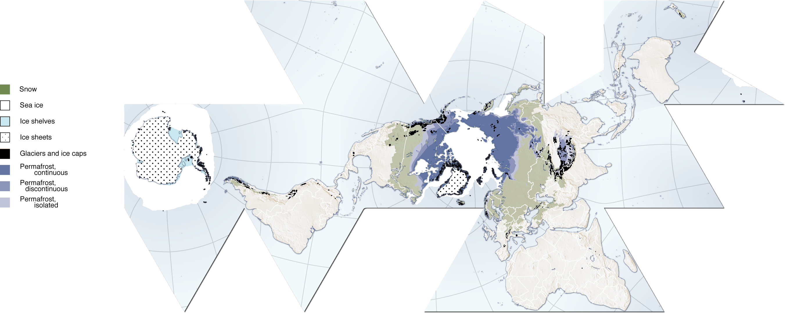
| DescripcióCryosphere Fuller Projection.png |
(Cryosphere) English: Author, Hugo Ahlenius, UNEP/GRID-Arendal. Full graphic, including sources, referencing etc are available here: http://maps.grida.no/go/graphic/cryosphere
.Image donated by author, no restrictions on use. Notes: Snow cover extent for Northern Hemisphere is represented by the 1966-2005 February average, for Southern Hemisphere by the 1987-2003 August average. Sea ice extent for Northern Hemisphere is represented by the 1979-2003 March average, for Southern Hemisphere by the 1979-2002 September average. Permafrost data for mountain areas and for the Southern Hemisphere are not represented in this map, neither are river and lake ice. Data sources: Armstrong, R.L. and Brodzik, M.J. (2005). Northern Hemisphere EASE-Grid weekly snow cover and sea ice extent version 3. (Digital media). National Snow and Ice Data Center, Boulder Armstrong, R.L., Brodzik, M.J., Knowles, K. and Savoie, M. (2005). Global monthly EASE-Grid snow water equivalent climatology. (Digital media). National Snow and Ice Data Center, Boulder Brown, J., Ferrians Jr., O.J., Heginbottom, J.A. and Melnikov, E.S. (1998 revised February 2001). Circum-Arctic map of permafrost and ground-ice conditions. (Digital media). National Snow and Ice Data Center/World Data Center for Glaciology, Boulder NGA (2000). Vector Map Level 0. National Geospatial-Intelligence Agency. http://geoengine.nima.mil/ftpdir/archive/vpf_ data/v0soa.tar.gz [Accessed 1 September 2006] Stroeve, J. and Meier, W. (1999, updated 2005). Sea Ice Trends and Climatologies from SMMR and SSM/I. National Snow and Ice Data Center. http://nsidc.org/data/smmr_ssmi_ ancillary/monthly_means.html [Accessed 20 April 2007] |
| Data | 12 de juny de 2007 (original upload date) |
| Font |
http://www.grida.no/graphicslib/detail/the-cryosphere-world-map_e290 Transferred from en.wikipedia to Commons by Pixeltoo using CommonsHelper. |
| Autor | Fraxen de la Viquipèdia en anglès |
Llicència

|
S'autoritza la còpia, la distribució i la modificació d'aquest document sota els termes de la llicència de documentació lliure GNU versió 1.2 o qualsevol altra versió posterior que publiqui la Free Software Foundation; sense seccions invariants, ni textos de portada, ni textos de contraportada. S'inclou una còpia d'aquesta llicència en la secció titulada GNU Free Documentation License.http://www.gnu.org/copyleft/fdl.htmlGFDLGNU Free Documentation Licensetruetrue |
| Aquest fitxer està subjecte a la llicència de Creative Commons Reconeixement i Compartir Igual 3.0 No adaptada. | ||
| Reconeixement: Fraxen de la Viquipèdia en anglès | ||
| ||
| Aquest avís de llicència s'ha afegit a aquest fitxer d'acord amb l'actualització de la llicència GFDL.http://creativecommons.org/licenses/by-sa/3.0/CC BY-SA 3.0Creative Commons Attribution-Share Alike 3.0truetrue |
- Sou lliure de:
- compartir – copiar, distribuir i comunicar públicament l'obra
- adaptar – fer-ne obres derivades
- Amb les condicions següents:
- reconeixement – Heu de donar la informació adequada sobre l'autor, proporcionar un enllaç a la llicència i indicar si s'han realitzat canvis. Podeu fer-ho amb qualsevol mitjà raonable, però de cap manera no suggereixi que l'autor us dóna suport o aprova l'ús que en feu.
- compartir igual – Si modifiqueu, transformeu, o generareu amb el material, haureu de distribuir les vostres contribucions sota una llicència similar o una de compatible com l'original
Registre original de càrregues
- 2007-06-12 08:06 Fraxen 2703×1079× (1080674 bytes)
- 2007-06-12 08:04 Fraxen 500×200× (73656 bytes)
- 2007-06-12 08:00 Fraxen 2703×1079× (1080674 bytes) Author, Hugo Ahlenius, UNEP/GRID-Arendal. Full graphic, including sources, referencing etc are available here: http://maps.grida.no/go/graphic/cryosphere Image donated by author, no restrictions on use. Notes: Snow cover extent for Northern Hemisphere is
Llegendes
Elements representats en aquest fitxer
representa l'entitat
12 juny 2007
image/png
7be9b55074ffbbb08dc7843d16b86e2bc818f6aa
1.075.432 byte
1.079 píxel
2.703 píxel
Historial del fitxer
Cliqueu una data/hora per veure el fitxer tal com era aleshores.
| Data/hora | Miniatura | Dimensions | Usuari/a | Comentari | |
|---|---|---|---|---|---|
| actual | 18:48, 3 des 2014 | 2.703 × 1.079 (1,03 Mo) | Gabrielsanz | Added the areas of glaciers and ice sheet in Sierra Nevada de Mérida (see Pico Bolívar, Pico Humboldt and [[Category:Glaciers of Venezuela|Glacier... | |
| 17:57, 3 des 2014 | 2.703 × 1.079 (1,03 Mo) | Gabrielsanz | Added the area of glaciers and ice cap located in Sierra Nevada de Mérida (see Pico Bolívar and Pico Humboldt) | ||
| 12:56, 23 nov 2008 | 2.703 × 1.079 (1,03 Mo) | File Upload Bot (Magnus Manske) | {{BotMoveToCommons|en.wikipedia}} {{Information |Description={{en|Author, Hugo Ahlenius, UNEP/GRID-Arendal. Full graphic, including sources, referencing etc are available here: http://maps.grida.no/go/graphic/cryosphere Image donated by author, no restri |
Ús del fitxer
La pàgina següent utilitza aquest fitxer:
Ús global del fitxer
Utilització d'aquest fitxer en altres wikis:
- Utilització a ar.wikipedia.org
- Utilització a ast.wikipedia.org
- Utilització a az.wikipedia.org
- Utilització a el.wikipedia.org
- Utilització a en.wikipedia.org
- Utilització a en.wikiversity.org
- User:Marshallsumter/Rocks/Glaciers/Astroglaciology
- User:Marshallsumter/Rocks/Glaciers/Astroglaciology/Quiz
- Callisto/Quiz
- User:Marshallsumter/Rocks/Ice sheets/Europa/Quiz
- User:Marshallsumter/Rocks/Rocky objects/Ganymede/Quiz
- Stars/Solar systems/Quiz
- User:Marshallsumter/Rocks/Rocky objects/Earth
- Minerals/Ices/Brittle ices/Quiz
- User:Marshallsumter/Rocks/Glaciers/Quiz
- User:Marshallsumter/Rocks/Glaciers/Glaciology/Quiz
- User:Marshallsumter/Rocks/Ice sheets/Enceladus/Quiz
- Minerals/Ices/Black ices/Quiz
- Ice sheets/Quiz
- User:Marshallsumter/Radiation astronomy/Earth
- Utilització a es.wikipedia.org
- Utilització a et.wikipedia.org
- Utilització a eu.wikipedia.org
- Utilització a fa.wikipedia.org
- Utilització a fr.wikipedia.org
- Utilització a id.wikipedia.org
- Utilització a it.wikipedia.org
- Utilització a ja.wikipedia.org
- Utilització a ka.wikipedia.org
- Utilització a la.wikipedia.org
- Utilització a nn.wikipedia.org
- Utilització a om.wikipedia.org
- Utilització a ro.wikipedia.org
- Utilització a si.wikipedia.org
- Utilització a sr.wikipedia.org
- Utilització a th.wikipedia.org
- Utilització a tr.wikipedia.org
- Utilització a uk.wikipedia.org
- Utilització a ur.wikipedia.org
- Utilització a vi.wikipedia.org
- Utilització a zh.wikipedia.org
- Utilització a zu.wikipedia.org
Metadades
Aquest fitxer conté informació addicional, probablement afegida per la càmera digital o l'escàner utilitzat per a crear-lo o digitalitzar-lo. Si s'ha modificat posteriorment, alguns detalls poden no reflectir les dades reals del fitxer modificat.
| Resolució horitzontal | 28,35 ppc |
|---|---|
| Resolució vertical | 28,35 ppc |