Fitxer:Asia_Minor_188_BCE.jpg
From Wikipedia, the free encyclopedia
Fitxer original (1.045 × 572 píxels, mida del fitxer: 483 Ko, tipus MIME: image/jpeg)
| Aquest fitxer i la informació mostrada a continuació provenen del dipòsit multimèdia lliure Wikimedia Commons. |
Resum
| DescripcióAsia Minor 188 BCE.jpg |
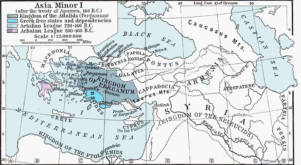
English: "The Growth of Roman Power in Asia Minor" from The Historical Atlas by en:William Robert Shepherd, 1923. Accessed from the Perry-Castañeda Library
Map Collection, http://www.lib.utexas.edu/maps/historical/shepherd/asia_minor_roman_power.jpg en:Category:Historical maps by William R. Shepherd Category:Maps showing history by William R. Shepherd Category:188 BC |
| Font | Transferred from en.wikipedia to Commons. Transfer was stated to be made by User:Blast. |
| Autor | en:William Robert Shepherd |
Llicència
| Public domainPublic domainfalsefalse |
|
Aquest material està en domini públic als Estats Units i als altres països on el dret d'autor s'estén per 70 anys (o menys) després de la mort de l'autor. Note that a few countries have copyright terms longer than 70 years: Mexico has 100 years, Jamaica has 95 years, Colombia has 80 years, and Guatemala and Samoa have 75 years. This image may not be in the public domain in these countries, which moreover do not implement the rule of the shorter term. Honduras has a general copyright term of 75 years, but it does implement the rule of the shorter term. Copyright may extend on works created by French who died for France in World War II (more information), Russians who served in the Eastern Front of World War II (known as the Great Patriotic War in Russia) and posthumously rehabilitated victims of Soviet repressions (more information).
| |
| Aquest fitxer està identificat com a lliure de restriccions conegudes sota la llei de drets d'autor, inclosos els drets veïns. | |
https://creativecommons.org/publicdomain/mark/1.0/PDMCreative Commons Public Domain Mark 1.0falsefalse
| Public domainPublic domainfalsefalse |
Aquest fitxer és en el domini públic en els Estats Units. Això és aplicable a obres dels EUA on el copyright ha expirat, sovint perquè la seva primera publicació va ser abans de l'1 de gener de 1929. Vegeu aquesta pàgina per a més detalls.
|
 | |
 |
Podria ser que aquesta imatge no estigui en el domini públic fora dels Estats Units (especialment on no s'aplica la regla del termini més curt per obres dels EUA, com Canada, la Xina continental (no a Hong Kong ni Macau), Alemanya, Mèxic i Suïssa). El creador i any de publicació són informació essencial i s'han de proporcionar. Vegeu Viquipèdia:Drets d'autor per a més detalls.
|
Registre original de càrregues
- 2006-04-25 03:50 Fishal 1045×572×8 (145387 bytes) "The Growth of Roman Power in Asia Minor" from The Historical Atlas by William R. Shepherd, 1923. Accessed from the Perry-Castañeda Library Map Collection, http://www.lib.utexas.edu/maps/historical/shepherd/asia_minor_roman_power.jpg
Llegendes
Elements representats en aquest fitxer
representa l'entitat
image/jpeg
581255ff713a3e45cceb07686c8f4019596e2796
494.958 byte
572 píxel
1.045 píxel
Historial del fitxer
Cliqueu una data/hora per veure el fitxer tal com era aleshores.
| Data/hora | Miniatura | Dimensions | Usuari/a | Comentari | |
|---|---|---|---|---|---|
| actual | 01:09, 10 nov 2020 | | 1.045 × 572 (483 Ko) | Hohum | Tweak |
| 01:03, 10 nov 2020 |  | 1.045 × 572 (352 Ko) | Hohum | Reworked from original | |
| 03:08, 6 gen 2013 |  | 1.015 × 568 (373 Ko) | Nelg | General and specific color adjustments, sharpening, crop. From file given at source. | |
| 19:31, 26 abr 2012 |  | 1.045 × 572 (238 Ko) | Yann | better contrast | |
| 16:25, 6 des 2007 |  | 1.045 × 572 (142 Ko) | File Upload Bot (Magnus Manske) | {{BotMoveToCommons|en.wikipedia}} {{Information |Description={{en|"The Growth of Roman Power in Asia Minor" from The Historical Atlas by William R. Shepherd, 1923. Accessed from the Perry-Castañeda Library Map Collection, http://www.lib.utexas.edu/maps |
Ús del fitxer
Les 2 pàgines següents utilitzen aquest fitxer:
Ús global del fitxer
Utilització d'aquest fitxer en altres wikis:
- Utilització a af.wikipedia.org
- Utilització a ar.wikipedia.org
- Utilització a azb.wikipedia.org
- Utilització a bg.wikipedia.org
- Utilització a br.wikipedia.org
- Utilització a cs.wikipedia.org
- Utilització a el.wikipedia.org
- Utilització a en.wikipedia.org
- Seleucid Empire
- Battle of Magnesia
- Kingdom of Pergamon
- Bergama
- Battle of Thermopylae (191 BC)
- Battle of Myonessus
- Battle of Nicaea
- Cretan War (205–200 BC)
- War against Nabis
- Roman–Seleucid war
- Library of Pergamum
- Galatian War
- Battle of Mount Olympus
- Maccabean Revolt
- Classical Anatolia
- Timeline of the Second Temple period
- User:Falcaorib/Ancient Empires (300 BC-01 AD)
- Utilització a et.wikipedia.org
- Utilització a eu.wikipedia.org
- Utilització a fa.wikipedia.org
- Utilització a fi.wikipedia.org
- Utilització a fr.wikipedia.org
- Utilització a he.wikipedia.org
Vegeu més usos globals d'aquest fitxer.
Metadades
Aquest fitxer conté informació addicional, probablement afegida per la càmera digital o l'escàner utilitzat per a crear-lo o digitalitzar-lo. Si s'ha modificat posteriorment, alguns detalls poden no reflectir les dades reals del fitxer modificat.
| Resolució horitzontal | 96 ppp |
|---|---|
| Resolució vertical | 96 ppp |
| Programari utilitzat | GIMP 2.10.20 |
| Data i hora de modificació del fitxer | 23:09, 9 nov 2020 |
| Espai de color | sRGB |
| ID únic del document original | xmp.did:360c72f3-0c29-44c3-a10a-0171390a648b |