Restr:British_Empire_1921_IndianSubcontinent.png
From Wikipedia, the free encyclopedia
Ment ar rakweled-mañ : 800 × 351 piksel. pizhderioù all : 320 × 140 piksel | 640 × 281 piksel | 1 425 × 625 piksel.
Restr orin (1 425 × 625 piksel, ment ar restr : 39 Kio, seurt MIME : image/png)
![]()
| Tennet eo ar restr-mañ eus Wikimedia Commons ha gallout a ra bezañ implijet evit raktresoù all. Diskouezet eo deskrivadur he fajenn zeskrivañ amañ dindan. |
Diverradur
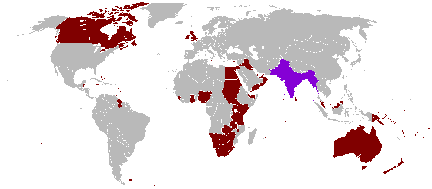
| DeskrivadurBritish Empire 1921 IndianSubcontinent.png |
English: A map of the British Empire in 1921 when it was at its height with British India indicated when it too was at its height as well. |
|||
| Deiziad | Uploaded on 27 Eost 2008, 21:41. | |||
| Mammenn | Labour an-unan | |||
| Aozer | Vadac. | |||
| Aotre (Adimplij ar restr-mañ) |
|
|||
| Stummoù all | File:British Empire 1921.png, File:British and French empires 1920.png |

|
This historical map image could be re-created using vector graphics as an SVG file. This has several advantages; see Commons:Media for cleanup for more information. If an SVG form of this image is available, please upload it and afterwards replace this template with
{{vector version available|new image name}}.
It is recommended to name the SVG file “British Empire 1921 IndianSubcontinent.svg”—then the template Vector version available (or Vva) does not need the new image name parameter. |
Captions
Add a one-line explanation of what this file represents
Items portrayed in this file
diskouez a ra
source of file saozneg
original creation by uploader saozneg
27 Eos 2008
image/png
checksum saozneg
935a8207c6efd79b6497ccded2c46d1acda52b0f
40 066 byte
625 pixel
1 425 pixel
Istor ar restr
Klikañ war un deiziad/eur da welet ar restr evel ma oa da neuze.
| Deiziad/Eur | Munud | Mentoù | Implijer | Notenn | |
|---|---|---|---|---|---|
| red | 31 Her 2021 da 07:59 | | 1 425 × 625 (39 Kio) | Randomastwritter | . |
| 13 Eos 2016 da 22:25 |  | 1 425 × 625 (39 Kio) | RickoTroanman22 | Tibet re-added | |
| 7 Mae 2011 da 18:58 |  | 1 425 × 625 (50 Kio) | Quigley | Correct China's borders closer to what was internationally recognized at the time | |
| 13 Her 2010 da 01:42 |  | 1 425 × 625 (50 Kio) | Vadac | Aden was not part of the British Raj. Matched map to File:British Empire 1921.png | |
| 11 Gen 2006 da 18:03 |  | 1 345 × 614 (28 Kio) | Miljoshi | More Changes as per w:Talk:British Raj. | |
| 9 Gen 2006 da 10:21 |  | 1 345 × 614 (28 Kio) | Miljoshi | Correcting wrong inclusion of Nicaragua - w:User:Big Adamsky | |
| 6 Gen 2006 da 11:51 |  | 1 345 × 614 (22 Kio) | Miljoshi | Discounting Sri Lanka | |
| 6 Gen 2006 da 10:30 |  | 1 345 × 614 (22 Kio) | Miljoshi | Updated map with corrections in Aden, Lebanon, Nicaragua, New Caledonia, Goa, Daman, Pondycherri. | |
| 5 Gen 2006 da 17:01 |  | 1 345 × 614 (23 Kio) | Miljoshi | British Empire in 1921 - Indian subcontinent is highlighted in purple. Image based on GFDL Image:British Empire 1921.png by w:Arthur Wellesley |
Implij ar restr
Pajenn ebet ne implij ar restr-mañ.
Implij hollek ar restr
Ober a ra ar wikioù da-heul gant ar restr-mañ :
- Implij war af.wikipedia.org
- Implij war bg.wikipedia.org
- Implij war da.wikipedia.org
- Implij war de.wikipedia.org
- Implij war en.wikipedia.org
- Implij war es.wikipedia.org
- Implij war hy.wikipedia.org
- Implij war id.wikipedia.org
- Implij war kk.wikipedia.org
- Implij war kn.wikipedia.org
- Implij war ml.wikipedia.org
- Implij war nl.wikipedia.org
- Implij war nn.wikipedia.org
- Implij war no.wikipedia.org
- Implij war ru.wikipedia.org
- Implij war tum.wikipedia.org
- Implij war uz.wikipedia.org
- Implij war vep.wikipedia.org
Metaroadennoù
Titouroù ouzhpenn zo er restr-mañ; bet lakaet moarvat gant ar c'hamera niverel pe ar skanner implijet evit he niverelaat. Mard eo bet cheñchet ar skeudenn e-keñver he stad orin marteze ne vo ket kenkoulz munudoù zo e-keñver ar skeudenn kemmet.
| Pizhder led ar skeudenn | 47,24 dpc |
|---|---|
| Pizhder hed ar skeudenn | 47,24 dpc |
| Deiziad hag eur kemm restr | 1 Du 2007 da 22:48 |