File:Czechoslovakia_I.png
From Wikipedia, the free encyclopedia
Ment ar rakweled-mañ : 800 × 364 piksel. pizhderioù all : 320 × 146 piksel | 640 × 291 piksel | 1 128 × 513 piksel.
Restr orin (1 128 × 513 piksel, ment ar restr : 66 Kio, seurt MIME : image/png)
![]()
| Tennet eo ar restr-mañ eus Wikimedia Commons ha gallout a ra bezañ implijet evit raktresoù all. Diskouezet eo deskrivadur he fajenn zeskrivañ amañ dindan. |
| DeskrivadurCzechoslovakia I.png |
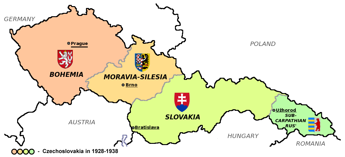
Čeština: Zemská mapa Československa v letech 1928 až 1938 s vyznačenými zemskými hlavními městy a znaky jednotlivých zemí English: Maps of Czechoslovakia in 1928-1938 with marked borders of all four Czechoslovak countries and their coats of arms and regional capital cities
Based on Image:Czechoslovakia_COA_medium.svg. * |
| Deiziad | (UTC) |
| Mammenn | |
| Aozer | |
| Stummoù all |
Derivative works of this file: |
| This is a retouched picture, which means that it has been digitally altered from its original version. Modifications: Simplified map. The original can be viewed here: CarpathianRutheniaCoA.svg:
|
Emañ ar restr-mañ dindan an aotre-implijout Creative Commons Deroadenn-Kenrannañ 3.0 Unported
- Gallout a rit :
- eskemm – eilañ, skignañ ha treuzkas an oberenn-mañ
- kemmañ – azasaat an oberenn-mañ
- diouzh ma heuilhit kement-mañ :
- deroadenn – Rankout a rit reiñ an titouroù perc'henniezh rekis diwar-benn an aozer, pourchas ul liamm war-zu an aotre-implijout ha merkañ hag-eñ ez eus bet graet kemmoù. Gallout a rit en ober en un doare reizh met hep lakaat da grediñ ez oc'h bet aprouet gantañ pe ez eo aprouet gantañ implij an oberenn-mañ.
- eskemmañ rik-ha-rik – Ma tegasit kemmoù, ma treuzfurmit pe ma savit un dra bennak diwar an oberenn-mañ e rankit skignañ an oberenn krouet ganeoc'h dindan an hevelep aotre-implijout pe un aotre-implijout kar-tost d'an hini orin.
Marilh orin ar pellgargadurioù
This image is a derivative work of the following images:
- File:Czechoslovakia01.png licensed with PD-self
- 2011-05-19T10:54:48Z PANONIAN 1128x513 (64020 Bytes) minor change, marked provincial capitals
- 2011-05-17T09:53:27Z PANONIAN 1128x513 (63994 Bytes) Reverted to version as of 10:38, 24 April 2011 - because this is map of Czechoslovakia and it was capital of Czechoslovakia
- 2011-05-17T05:07:38Z Millenium187 1128x513 (56086 Bytes) Why was Prague underlined and Vienna, Brno, Bratislava and other capital cities were not? -- corrected
- 2011-04-24T10:38:30Z PANONIAN 1128x513 (63994 Bytes) few corrections
- 2011-04-23T11:31:49Z PANONIAN 1128x509 (62348 Bytes) improved version
- 2008-12-20T20:58:14Z Kirk 1100x497 (80038 Bytes) {{Information |Description= |Source= |Date= |Author= |Permission= |other_versions= }}
- 2006-12-28T16:11:35Z Electionworld 1100x497 (92110 Bytes) {{ew|en|PANONIAN}} Map of {{link|Czechoslovakia}} (self made) Note: The provinces shown on the map were introduced by Act No. 125/1927 Zb. and became effective in 1928. {{PD-self}} [[Category:Maps of Czechoslovakia]] [[Cat
- File:Small_coat_of_arms_of_the_Czech_Republic2.png licensed with PD-self
- 2006-07-18T15:34:18Z Poznaniak 486x594 (126651 Bytes) {{Information |Description=Godło Czech |Source=własna praca |Date=18.07.2006 |Author=[[:user:Poznaniak|Poznaniak]] |Permission= }}
- File:Moravia-Silesia.png licensed with PD-self
- 2010-07-25T21:44:29Z RgC 490x600 (65918 Bytes) {{Information |Description={{en|1=Joint of coat of arms of Moravia and Silesia.}} |Source={{own}} |Author=[[User:RgC|RgC]] |Date=2010-07-25 |Permission= |other_versions= }} [[Category:User page images]]
- File:Coat_of_arms_of_Slovakia.svg licensed with Cc-by-sa-3.0-migrated, GFDL
- 2006-06-06T21:41:47Z Tlusťa 400x500 (4623 Bytes) ==Summary== {{Information |Description={{en|Coat of arms of the [[Slovakia]].}} {{cs|Znak [[:cs:Slovensko|Slovenska]].}} |Source= |Date= |Author=[[User:Tlusťa|Tlusťa]] |Permission= |other_versions= }} ==Licensing == {{GFDL
- File:CarpathianRutheniaCoA.svg licensed with Cc-pd-mark-footer, PD-old
- 2007-06-01T16:53:20Z DDima 325x394 (27235 Bytes) fix colors
- 2006-11-08T06:35:05Z Happenstance 325x394 (27214 Bytes) created
Uploaded with derivativeFX
| Annotations InfoField | This image is annotated: View the annotations at Commons |
426
165
76
76
1128
513
Wrong coat of arms (violation of WP:NOR) – Moravian-Silesian Province had CoA composed of double shield, placed side by side (one with Moravian and one with Silesian eagle)
Captions
Add a one-line explanation of what this file represents
Items portrayed in this file
diskouez a ra
12 Eos 2011
image/png
checksum saozneg
196c82b4bea76f59cd4e74d855e6f7b5162451a4
67 684 byte
513 pixel
1 128 pixel
Istor ar restr
Klikañ war un deiziad/eur da welet ar restr evel ma oa da neuze.
| Deiziad/Eur | Munud | Mentoù | Implijer | Notenn | |
|---|---|---|---|---|---|
| red | 12 Eos 2011 da 18:40 | | 1 128 × 513 (66 Kio) | Millenium187 | {{Information |Description={{cs|Zemská mapa Československa v letech 1928 až 1938 s vyznačenými zemskými hlavními městy a znaky jednotlivých zemí}} {{en|Maps of Czechoslovakia in 1928-1938 with marked borders of all four Czechoslovak countries a |
Implij ar restr
Pajenn ebet ne implij ar restr-mañ.
Implij hollek ar restr
Ober a ra ar wikioù da-heul gant ar restr-mañ :
- Implij war azb.wikipedia.org
- Implij war az.wikipedia.org
- Implij war bn.wikipedia.org
- Implij war da.wikipedia.org
- Implij war de.wikipedia.org
- Implij war el.wikipedia.org
- Implij war en.wikipedia.org
- Implij war es.wikipedia.org
- Implij war he.wikipedia.org
- Implij war io.wikipedia.org
- Implij war mk.wikipedia.org
- Implij war mt.wikipedia.org
- Implij war sq.wikipedia.org
- Implij war te.wikipedia.org
- Implij war th.wikipedia.org
- Implij war tr.wikipedia.org
- Implij war uk.wikipedia.org
Adtapet diwar « https://br.wikipedia.org/wiki/Restr:Czechoslovakia_I.png »