File:Rzeczpospolita.png
From Wikipedia, the free encyclopedia
Арыгінальны файл (2 000 × 1 568 кропак, аб’ём файла: 332 KB, тып MIME: image/png)
Гэты файл з на Вікісховішчы і можа выкарыстоўвацца іншымі праектамі. Апісанне на яго старонцы ў Wikimedia Commons прыведзена ніжэй.
Тлумачэнне
| АпісаннеRzeczpospolita.png |
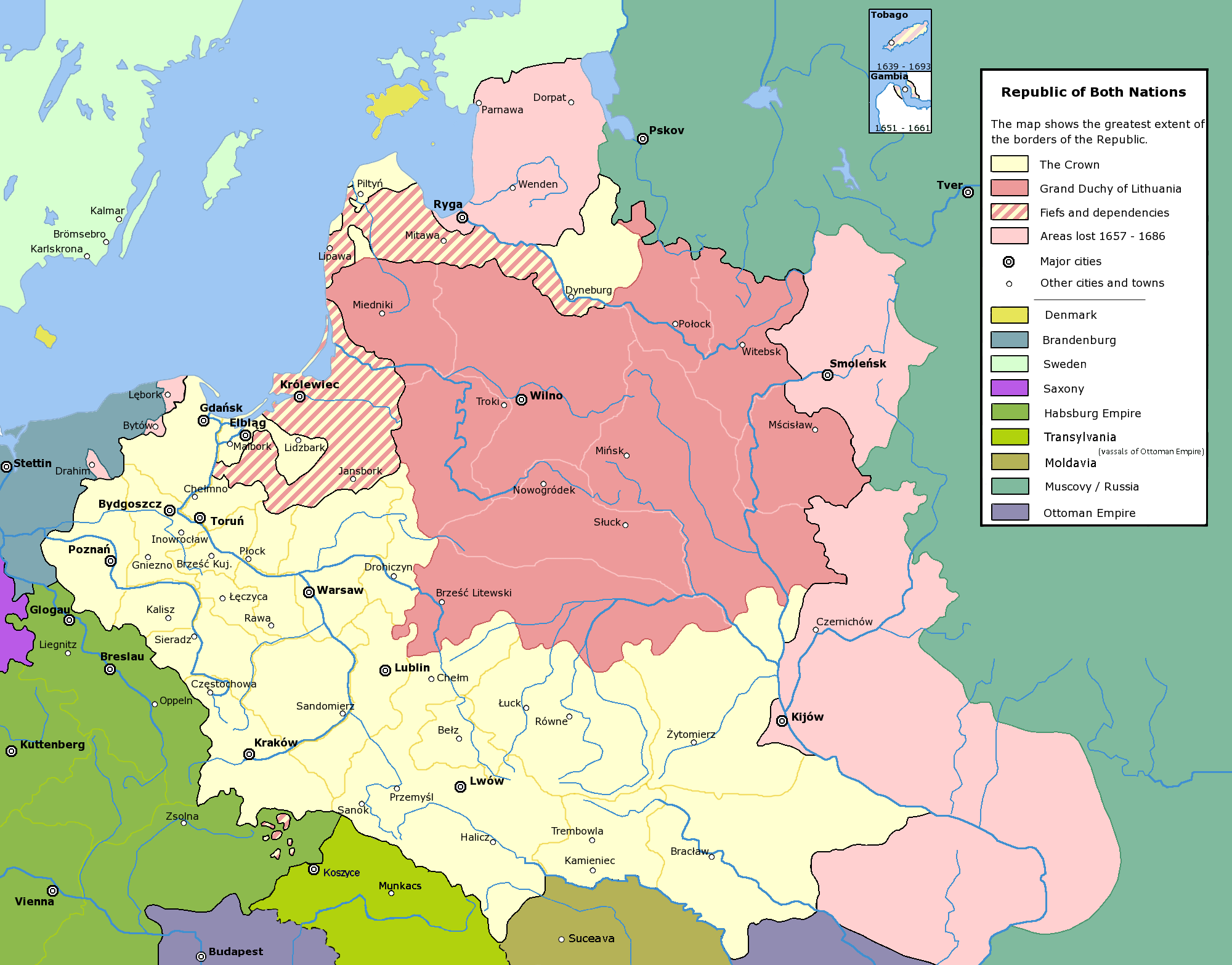
English: Commonwealth of Both Nations at the peak of its strength. The areas marked with light pink were lost to:
|
| Дата | |
| Крыніца | Уласная праца |
| Аўтар | Halibutt |
| Дазвол (Паўторнае выкарыстанне гэтага файла) |
GFDL, see below |
| Іншыя версіі |
|

|
This historical map image could be re-created using vector graphics as an SVG file. This has several advantages; see Commons:Media for cleanup for more information. If an SVG form of this image is available, please upload it and afterwards replace this template with
{{vector version available|new image name}}.
It is recommended to name the SVG file “Rzeczpospolita.svg”—then the template Vector version available (or Vva) does not need the new image name parameter. |
Ліцэнзіяванне
Since the legal status of the above comment has been questioned, I hereby grant anyone the right to treat it as either a standard copyright notice, invariant section, legal statement, legal advice, friendly suggestion or a mere comment, depending on his or hers own choice. |
|

History of Poland
The following is a list of maps created by Halibutt and uploaded to commons, as well as their present and projected derivatives.
| Parent Image | Image | Description | |||||||||||
|---|---|---|---|---|---|---|---|---|---|---|---|---|---|
| Maps by Halibutt | |||||||||||||
| Image:Rzeczpospolita.png | Image:Rzeczpospolita.png | The Republic in 17th and 18th century | |||||||||||
| Image:Rzeczpospolita 1600.png | The Republic after the Treaty of Dywilino | ||||||||||||
| Image:Rzeczpospolita voivodships.png | Voivodships of The Republic | ||||||||||||
| Image:Rzeczpospolita_Potop.png | The Republic during The Deluge and Chmielnicki Uprising, with major battles of the era marked | ||||||||||||
| Magnates and their lands and domains | |||||||||||||
| 1st • 2nd • 3rd | Partitions of Poland | ||||||||||||
| War of the constitution | |||||||||||||
| Image:Rzeczpospolita.xcf | SOURCE FILE - GIMP format | ||||||||||||
| Image:Poland 1939.png | Image:Poland 1939.png | Poland in 1939 | |||||||||||
| Image:Dywizje wrzesien 1.png | Order of Battle on September 1st, during the Polish Defence War of 1939 | ||||||||||||
| Image:Poland 1939.xcf | SOURCE FILE - GIMP format | ||||||||||||
| Image:Polska kontur bialy.png | Image:Polska kontur bialy.png | Contour map of Poland AD 1999, for use with various locator maps | |||||||||||
| Image:Rzeczpospolita 1923.png | Image:Rzeczpospolita 1923.png | Map of Poland 1918-1939, currently under development | |||||||||||
| Image:PBW March 1919.png | Polish-Bolshevik War - fronts in March of 1919 | ||||||||||||
| Image:PBW December 1919.png | Polish-Bolshevik War - fronts in December of 1919 | ||||||||||||
| Image:PBW June 1920.png | Polish-Bolshevik War - fronts in July of 1920 | ||||||||||||
| Image:PBW August 1920.png | Polish-Bolshevik War - fronts in August of 1920 | ||||||||||||
| Polish Defence War of 1939 | |||||||||||||
| Polish areas annexed by Germany, Lithuania, Slovakia and the Soviet Union | |||||||||||||
| German concentration camps in Poland | |||||||||||||
| Curzon line | |||||||||||||
| Major battles of the Polish-Bolshevik War | |||||||||||||
| names • no names | Polish/Czechoslovak/Lithuanian/German/Ukrainian claims in 1920's | ||||||||||||
| Image:Rzeczpospolita Central Lithuania.png | Central Lithuania | ||||||||||||
| Image:Rzeczpospolita Lithuania claims.png | Central Lithuania as compared with other Lithuanian claims | ||||||||||||
| Image:Rzeczpospolita 1789-1920.png | Post-1922 borders compared with the territory of Poland before the partitions | ||||||||||||
| Warsaw Uprising and the Operation Tempest | |||||||||||||
| Poland partitioned between the Soviets and the Germans | |||||||||||||
| Image:Rzeczpospolita 1939 Polish divisions.png | Polish divisions on September 1, 1939 | ||||||||||||
| Home Army inspectorates | |||||||||||||
| Image:Rzeczpospolita 1922.xcf | SOURCE FILE - GIMP format | ||||||||||||
| Image:Rzeczpospolita 1937.svg | Vector version!!!! | layered version available on request | |||||||||||

|
This image (or all images in this category) uses inside labels or attached captions in a specific script or language and should be converted to a language neutral form. This would allow its use in all Wikimedia projects and, more importantly, all Wikimedia languages.
Bahasa Melayu ∙ català ∙ čeština ∙ Deutsch ∙ English ∙ español ∙ français ∙ italiano ∙ magyar ∙ Nederlands ∙ Plattdüütsch ∙ português ∙ sicilianu ∙ slovenčina ∙ suomi ∙ беларуская (тарашкевіца) ∙ македонски ∙ русский ∙ српски / srpski ∙ 한국어 ∙ 日本語 ∙ 中文 ∙ 中文(简体) ∙ فارسی ∙ +/− |
Назвы
Элементы, адлюстраваныя на гэтым файле
адлюстроўвае
Нейкае значэнне без элементу ў Вікіданых
8 снежня 2004
Гісторыя файла
Націснуць на даце з часам, каб паказаць файл, якім ён тады быў.
| Дата і час | Драбніца | Памеры | Удзельнік | Тлумачэнне | |
|---|---|---|---|---|---|
| актуальн. | 17:37, 6 мая 2016 | | 2 000 × 1 568 (332 KB) | Julieta39 | Cosmetic changes: see sources in the discussion page of today. |
| 13:40, 8 снежня 2009 |  | 2 000 × 1 568 (221 KB) | Tryphon | Removed watermark. | |
| 22:34, 13 снежня 2004 |  | 2 000 × 1 568 (304 KB) | Halibutt | Ok, final version at last (unless you have some more comments or suggestions) | |
| 10:47, 10 снежня 2004 |  | 2 000 × 1 568 (297 KB) | Halibutt | final version? | |
| 04:36, 10 снежня 2004 |  | 2 000 × 1 568 (193 KB) | Halibutt | new update | |
| 06:23, 8 снежня 2004 |  | 2 000 × 1 568 (141 KB) | Halibutt | Commonwealth of Both Nations at the peak of its strength<br>Beta version of a map by Halibutt<br>{{User:Halibutt/GFDL}} |
Выкарыстанне файла
Няма старонак, якія выкарыстоўваюць гэты файл.
Глабальнае выкарыстанне файла
Гэты файл выкарыстоўваецца ў наступных вікі:
- Выкарыстанне ў ar.wikipedia.org
- Выкарыстанне ў arz.wikipedia.org
- Выкарыстанне ў azb.wikipedia.org
- Выкарыстанне ў bg.wikipedia.org
- Выкарыстанне ў br.wikipedia.org
- Выкарыстанне ў ca.wikipedia.org
- Выкарыстанне ў da.wikipedia.org
- Выкарыстанне ў de.wikipedia.org
- Выкарыстанне ў de.wikibooks.org
- Выкарыстанне ў en.wikipedia.org
- John III Sobieski
- User:Halibutt
- Stanisław Koniecpolski
- Wikipedia:Today's featured article/January 2005
- Wikipedia:Today's featured article/January 11, 2005
- Talk:Eastern and Western Vilnius regions
- Talk:Russian Mennonites
- User:Art Serebren
- User talk:Mikołajski
- User:Cyborg Ninja/sandbox
- User:Falcaorib/Poland-Lithuania
- Выкарыстанне ў eo.wikipedia.org
- Выкарыстанне ў et.wikipedia.org
- Выкарыстанне ў fi.wikipedia.org
- Выкарыстанне ў fr.wikipedia.org
- Выкарыстанне ў gl.wikipedia.org
- Выкарыстанне ў hr.wikipedia.org
- Выкарыстанне ў hsb.wikipedia.org
- Выкарыстанне ў hu.wikipedia.org
- Выкарыстанне ў id.wikipedia.org
- Выкарыстанне ў it.wikipedia.org
- Выкарыстанне ў ja.wikipedia.org
Паказаць глабальнае выкарыстанне гэтага файла.
Метаданыя
У файле ёсць дадатковыя звесткі, магчыма, дададзеныя лічбавай фотакамерай ці сканерам, з якіх гэты файл паходзіць. Калі арыгінальны файл быў зменены, то частка гэтых звестак магла страціць актуальнасць у дачыненні да змененага файла.
| Гарызантальная раздзяляльнасць | 28,35 dpc |
|---|---|
| Вертыкальная раздзяляльнасць | 28,35 dpc |