File:Map_Greece_expansion_1832-1947-es.svg
From Wikipedia, the free encyclopedia

Памер гэтага PNG-прагляду для SVG-файла: 457 × 599 пікселяў. Іншыя разрозненні: 183 × 240 пікселяў | 366 × 480 пікселяў | 586 × 768 пікселяў | 781 × 1 024 пікселяў | 1 562 × 2 048 пікселяў | 734 × 962 пікселяў.
Арыгінальны файл (файл SVG, намінальна 734 × 962 кропак, аб’ём файла: 981 KB)
Гэты файл з на Вікісховішчы і можа выкарыстоўвацца іншымі праектамі. Апісанне на яго старонцы ў Wikimedia Commons прыведзена ніжэй.
| АпісаннеMap Greece expansion 1832-1947-es.svg |
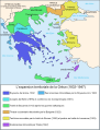
Čeština: Mapa zobrazuje územní expanzi Řeckého království (1832–1947). Dansk: Kort over Grækenlands territoriale udvidelser, 1832-1947. Deutsch: Territoriale Expansion Griechenlands 1832-1947. English: The territorial expansion of Greece, 1832-1947. Español: Mapa de la expansión territorial griega (1832-1947) Euskara: Greziaren lurralde hedapena 1832-1947 bitartean Français : L'expansion territoriale de la Grèce. 1832-1947. Hrvatski: Teritorijalno proširenje Grčke u razdoblju od 1832. do 1947. Italiano: L'espansione territoriale della Grecia dal 1832 al 1947 Magyar: Görögország területi növekedése (1832-1947) Occitan : Evolucions territòrialas de Grècia. Ελληνικά: Η εδαφική επέκταση της Ελλάδας 1832-1947. Македонски: Територијално проширување на Грција Українська: Територіальна експансія Греції (1832-1947). 日本語: ギリシャ王国の版図拡大 (1832-1947年) 中文: 希腊的领土变迁,1832年-1947年间。 العربية : خريطة تُصوِّر الأراضي التي استولت عليها اليونان مُنذُ سنة 1832م حين استقلالها عن الدولة العُثمانيَّة، وُصولًا إلى سنة 1947م |
||||||||
| Дата | |||||||||
| Крыніца | Image:Map Greece expansion 1832-1947-fr.svg (adaptation of Image:Population exchange 1923.gif, GFDL). Image renamed from Image:L'expansion territoriale de la Grèce 1832-1947.svg | ||||||||
| Аўтар | Historicair, translator Reignerok | ||||||||
| Дазвол (Паўторнае выкарыстанне гэтага файла) |
|
||||||||
| Іншыя версіі |
Derivative works of this file: GreciaEnEntreguerras.svg
[правіць]
|


.PNG)


.png)


Назвы
Апішыце ў адным радку, што ўяўляе сабой гэты файл
Элементы, адлюстраваныя на гэтым файле
адлюстроўвае
28 снежня 2007
image/svg+xml
Гісторыя файла
Націснуць на даце з часам, каб паказаць файл, якім ён тады быў.
| Дата і час | Драбніца | Памеры | Удзельнік | Тлумачэнне | |
|---|---|---|---|---|---|
| актуальн. | 02:31, 16 верасня 2023 | | 734 × 962 (981 KB) | Bsckr | File uploaded using svgtranslate tool (https://svgtranslate.toolforge.org/). Added translation for ca. |
| 01:06, 24 снежня 2022 |  | 734 × 962 (981 KB) | Wikijahnn | File uploaded using svgtranslate tool (https://svgtranslate.toolforge.org/). Added translation for ca. | |
| 12:48, 22 верасня 2021 |  | 734 × 962 (981 KB) | Quelcom | File uploaded using svgtranslate tool (https://svgtranslate.toolforge.org/). Added translation for ca. | |
| 14:09, 25 красавіка 2020 |  | 734 × 962 (923 KB) | Rowanwindwhistler | Attempt to make text easier to read in the articles by changing the font and the spacing. | |
| 13:55, 25 красавіка 2020 |  | 734 × 962 (470 KB) | Rowanwindwhistler | Fake text added | |
| 23:06, 28 снежня 2007 |  | 734 × 962 (110 KB) | Reignerok | {{Information |Description= {{es|Expansión territorial de Grecia, 1832-1947.}} |Source=Image:Map Greece expansion 1832-1947-fr.svg (adaptation of Image:Population exchange 1923.gif, GFDL). Image renamed from [[:Image:L'expansion territoriale de la G |
Выкарыстанне файла
Няма старонак, якія выкарыстоўваюць гэты файл.
Глабальнае выкарыстанне файла
Гэты файл выкарыстоўваецца ў наступных вікі:
- Выкарыстанне ў ast.wikipedia.org
- Выкарыстанне ў es.wikipedia.org
- Grecia
- Gran Idea
- Alejandro I de Grecia
- Jorge I de Grecia
- Reino de Grecia
- Historia de Grecia
- Tratado de Constantinopla (1832)
- Plantilla:Portada Bueno/256
- Wikipedia:Artículos buenos/Programación en portada/2008/Junio
- Plantilla:Portada Bueno/3401
- Relaciones internacionales de las Grandes Potencias (1814-1919)
- Panagiótis Danglís
- Tratado de Londres (1864)
- Convención de Constantinopla (1881)
- Protocolo de Londres (1830)
- Выкарыстанне ў pt.wikipedia.org
Метаданыя
У файле ёсць дадатковыя звесткі, магчыма, дададзеныя лічбавай фотакамерай ці сканерам, з якіх гэты файл паходзіць. Калі арыгінальны файл быў зменены, то частка гэтых звестак магла страціць актуальнасць у дачыненні да змененага файла.
| Шырыня | 733.534 |
|---|---|
| Вышыня | 961.51147 |