File:Greek_history_from_1832.GIF
From Wikipedia, the free encyclopedia

Памер папярэдняга прагляду: 800 × 575 пікселяў. Іншыя разрозненні: 320 × 230 пікселяў | 640 × 460 пікселяў | 868 × 624 пікселяў.
Арыгінальны файл (868 × 624 кропак, аб’ём файла: 29 KB, тып MIME: image/gif)
Гэты файл з на Вікісховішчы і можа выкарыстоўвацца іншымі праектамі. Апісанне на яго старонцы ў Wikimedia Commons прыведзена ніжэй.

|
This map image could be re-created using vector graphics as an SVG file. This has several advantages; see Commons:Media for cleanup for more information. If an SVG form of this image is available, please upload it and afterwards replace this template with
{{vector version available|new image name}}.
It is recommended to name the SVG file “Greek history from 1832.svg”—then the template Vector version available (or Vva) does not need the new image name parameter. |
Тлумачэнне
| АпісаннеGreek history from 1832.GIF |
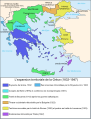
Čeština: Mapa zobrazuje územní expanzi Řeckého království (1832–1947). Dansk: Kort over Grækenlands territoriale udvidelser, 1832-1947. Deutsch: Territoriale Expansion Griechenlands 1832-1947. English: The territorial expansion of Greece, 1832-1947. Español: Mapa de la expansión territorial griega (1832-1947) Euskara: Greziaren lurralde hedapena 1832-1947 bitartean Français : L'expansion territoriale de la Grèce. 1832-1947. Hrvatski: Teritorijalno proširenje Grčke u razdoblju od 1832. do 1947. Italiano: L'espansione territoriale della Grecia dal 1832 al 1947 Magyar: Görögország területi növekedése (1832-1947) Occitan : Evolucions territòrialas de Grècia. Ελληνικά: Η εδαφική επέκταση της Ελλάδας 1832-1947. Македонски: Територијално проширување на Грција Українська: Територіальна експансія Греції (1832-1947). 日本語: ギリシャ王国の版図拡大 (1832-1947年) 中文: 希腊的领土变迁,1832年-1947年间。 العربية : خريطة تُصوِّر الأراضي التي استولت عليها اليونان مُنذُ سنة 1832م حين استقلالها عن الدولة العُثمانيَّة، وُصولًا إلى سنة 1947م |
||
| Дата | (UTC) | ||
| Крыніца |
This file was derived from: Greekhistory.GIF:
|
||
| Аўтар |
|
||
| Іншыя версіі |
[правіць]
|


.PNG)


.png)


| This is a retouched picture, which means that it has been digitally altered from its original version. Modifications: removed North Epirus; adjusted color of island borders. The original can be viewed here: Greekhistory.GIF:
|
Ліцэнзіяванне
Я, уладальнік аўтарскіх правоў на гэты твор, добраахвотна публікую яго на ўмовах наступных ліцэнзій:
| Гэты файл даступны па ліцэнзіі Creative Commons Пазначэнне аўтарства - На тых самых умовах 3.0 Непартаваная | ||
| ||
| Гэтая картка дададзеная ў якасці часткі абнаўлення ліцэнзіі GFDL.http://creativecommons.org/licenses/by-sa/3.0/CC BY-SA 3.0Creative Commons Attribution-Share Alike 3.0truetrue |

|
Дазваляецца капіяваць, распаўсюджваць і(або) мадыфікаваць гэты дакумент на ўмовах ліцэнзіі GNU FDL версіі 1.2 або навейшай, выдадзенай Фондам свабоднага праграмнага забеспячэння; без Нязменных раздзелаў, без тэкстаў Вокладак. Копія ліцэнзіі ёсць у раздзеле GNU Free Documentation License.http://www.gnu.org/copyleft/fdl.htmlGFDLGNU Free Documentation Licensetruetrue |
Вы можаце выбраць любую з гэтых ліцэнзій.
Журнал арыгінальнай загрузкі
This image is a derivative work of the following images:
- File:Greekhistory.GIF licensed with Cc-by-sa-3.0-migrated, GFDL
- 2011-09-18T23:23:25Z Vasarchit 868x624 (30397 Bytes) corrected Epirus borderline
- 2008-09-19T10:41:02Z Peeperman 868x624 (30394 Bytes) {{Information |Description= |Source= |Date= |Author= |Permission= |other_versions= }}
- 2006-10-15T09:50:38Z Christophe cagé 868x624 (29511 Bytes)
- 2006-10-15T09:49:50Z Christophe cagé 868x624 (29511 Bytes) == Summary == Map created by [[User:Adam Carr]], August 2006 - imported from en:wikipedia by ~~~~ == Licensing == {{GFDL-self}} [[Category:Maps of the history of Greece]]
Uploaded with derivativeFX
Назвы
Апішыце ў адным радку, што ўяўляе сабой гэты файл
Элементы, адлюстраваныя на гэтым файле
адлюстроўвае
3 чэрвеня 2013
Гісторыя файла
Націснуць на даце з часам, каб паказаць файл, якім ён тады быў.
| Дата і час | Драбніца | Памеры | Удзельнік | Тлумачэнне | |
|---|---|---|---|---|---|
| актуальн. | 19:45, 3 чэрвеня 2013 | | 868 × 624 (29 KB) | DrKay | == {{int:filedesc}} == {{Information |Description={{en|Territorial expansion of Greece (1832–1947).}} |Source={{Derived from|Greekhistory.GIF|display=50}} |Date=2013-06-03 16:43 (UTC) |Author=*File:Greekhistory.GIF: en:User:Adam Carr *deri... |
Выкарыстанне файла
Няма старонак, якія выкарыстоўваюць гэты файл.
Глабальнае выкарыстанне файла
Гэты файл выкарыстоўваецца ў наступных вікі:
- Выкарыстанне ў bg.wikipedia.org
- Выкарыстанне ў en.wikipedia.org
- Выкарыстанне ў hy.wikipedia.org
- Выкарыстанне ў ka.wikipedia.org
- Выкарыстанне ў sh.wikipedia.org