File:Czechoslovakia_I.png
From Wikipedia, the free encyclopedia
Gress dea Voaschau: 800 × 364 Pixel Weitere Auflésungan: 320 × 146 Pixel | 640 × 291 Pixel | 1.128 × 513 Pixel.
Version in hechara Auflesung (1.128 × 513 Pixel, Dateigress: 66 KB, MIME-Typ: image/png)
De Datei kimpt vo Wikimedia Commons. De Beschreibung vo da Dateibschreibungsseitn wead untn ozoagt.
| BschreiwungCzechoslovakia I.png |
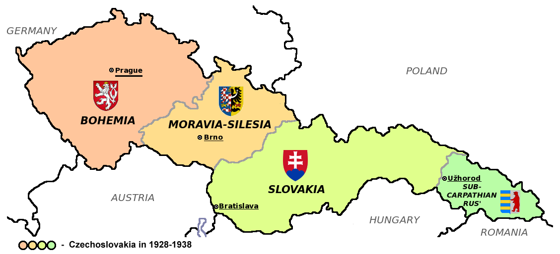
Čeština: Zemská mapa Československa v letech 1928 až 1938 s vyznačenými zemskými hlavními městy a znaky jednotlivých zemí English: Maps of Czechoslovakia in 1928-1938 with marked borders of all four Czechoslovak countries and their coats of arms and regional capital cities
Based on Image:Czechoslovakia_COA_medium.svg. * |
| Daatum | (UTC) |
| Quejn | |
| Urhéwer | |
| Aundre Versióner |
Derivative works of this file: |
| Dieses Bild wurde digital nachbearbeitet. Folgende Änderungen wurden vorgenommen: Simplified map. Das Originalbild kann hier eingesehen werden: CarpathianRutheniaCoA.svg:
|
Diese Datei ist unter der Creative-Commons-Lizenz „Namensnennung – Weitergabe unter gleichen Bedingungen 3.0 nicht portiert“ lizenziert.
- Dieses Werk darf von dir
- vabroatt wern – vafüfötigt, vabroatt und éffantlich zuegénglich gmocht wern.
- neu zusammengestellt werden – abgewandelt und bearbeitet werden
- Zu den folgenden Bedingungen:
- Nåmansnénnung – Du musst angemessene Urheber- und Rechteangaben machen, einen Link zur Lizenz beifügen und angeben, ob Änderungen vorgenommen wurden. Diese Angaben dürfen in jeder angemessenen Art und Weise gemacht werden, allerdings nicht so, dass der Eindruck entsteht, der Lizenzgeber unterstütze gerade dich oder deine Nutzung besonders.
- Weidergob unter gleiche Bedingungan – Wenn du das Material wiedermischst, transformierst oder darauf aufbaust, musst du deine Beiträge unter der gleichen oder einer kompatiblen Lizenz wie das Original verbreiten.
Ursprüngliches Datei-Logbuch
This image is a derivative work of the following images:
- File:Czechoslovakia01.png licensed with PD-self
- 2011-05-19T10:54:48Z PANONIAN 1128x513 (64020 Bytes) minor change, marked provincial capitals
- 2011-05-17T09:53:27Z PANONIAN 1128x513 (63994 Bytes) Reverted to version as of 10:38, 24 April 2011 - because this is map of Czechoslovakia and it was capital of Czechoslovakia
- 2011-05-17T05:07:38Z Millenium187 1128x513 (56086 Bytes) Why was Prague underlined and Vienna, Brno, Bratislava and other capital cities were not? -- corrected
- 2011-04-24T10:38:30Z PANONIAN 1128x513 (63994 Bytes) few corrections
- 2011-04-23T11:31:49Z PANONIAN 1128x509 (62348 Bytes) improved version
- 2008-12-20T20:58:14Z Kirk 1100x497 (80038 Bytes) {{Information |Description= |Source= |Date= |Author= |Permission= |other_versions= }}
- 2006-12-28T16:11:35Z Electionworld 1100x497 (92110 Bytes) {{ew|en|PANONIAN}} Map of {{link|Czechoslovakia}} (self made) Note: The provinces shown on the map were introduced by Act No. 125/1927 Zb. and became effective in 1928. {{PD-self}} [[Category:Maps of Czechoslovakia]] [[Cat
- File:Small_coat_of_arms_of_the_Czech_Republic2.png licensed with PD-self
- 2006-07-18T15:34:18Z Poznaniak 486x594 (126651 Bytes) {{Information |Description=Godło Czech |Source=własna praca |Date=18.07.2006 |Author=[[:user:Poznaniak|Poznaniak]] |Permission= }}
- File:Moravia-Silesia.png licensed with PD-self
- 2010-07-25T21:44:29Z RgC 490x600 (65918 Bytes) {{Information |Description={{en|1=Joint of coat of arms of Moravia and Silesia.}} |Source={{own}} |Author=[[User:RgC|RgC]] |Date=2010-07-25 |Permission= |other_versions= }} [[Category:User page images]]
- File:Coat_of_arms_of_Slovakia.svg licensed with Cc-by-sa-3.0-migrated, GFDL
- 2006-06-06T21:41:47Z Tlusťa 400x500 (4623 Bytes) ==Summary== {{Information |Description={{en|Coat of arms of the [[Slovakia]].}} {{cs|Znak [[:cs:Slovensko|Slovenska]].}} |Source= |Date= |Author=[[User:Tlusťa|Tlusťa]] |Permission= |other_versions= }} ==Licensing == {{GFDL
- File:CarpathianRutheniaCoA.svg licensed with Cc-pd-mark-footer, PD-old
- 2007-06-01T16:53:20Z DDima 325x394 (27235 Bytes) fix colors
- 2006-11-08T06:35:05Z Happenstance 325x394 (27214 Bytes) created
Hochgeladen mit derivativeFX
| Annotations InfoField | This image is annotated: View the annotations at Commons |
426
165
76
76
1128
513
Wrong coat of arms (violation of WP:NOR) – Moravian-Silesian Province had CoA composed of double shield, placed side by side (one with Moravian and one with Silesian eagle)
Kurzbeschreibungen
Ergänze eine einzeilige Erklärung, was diese Datei darstellt.
In dieser Datei abgebildete Objekte
Motiv Deutsch
Urheberrechtsstatus Deutsch
urheberrechtlich geschützt Deutsch
12. August 2011
MIME-Typ Deutsch
image/png
Prüfsumme Deutsch
196c82b4bea76f59cd4e74d855e6f7b5162451a4
Dateigröße Deutsch
67.684 Byte
513 Pixel
1.128 Pixel
Dateiversiona
Wensd auf an Zeitpunkt klickst, nacha konst a friaane Version lodn.
| Version vom | Vorschaubuidl | Dimensióna | Nutzer | Kommentar | |
|---|---|---|---|---|---|
| aktuell | 20:40, 12. Aug. 2011 | | 1.128 × 513 (66 KB) | Millenium187 | {{Information |Description={{cs|Zemská mapa Československa v letech 1928 až 1938 s vyznačenými zemskými hlavními městy a znaky jednotlivých zemí}} {{en|Maps of Czechoslovakia in 1928-1938 with marked borders of all four Czechoslovak countries a |
Dateivawendung
Koa Seitn nutzt de Datei.
Globale Dateinutzung
D'noochéfóiganden åndern Wikis vawénden dé Datei:
- Vawendung af azb.wikipedia.org
- Vawendung af az.wikipedia.org
- Vawendung af bn.wikipedia.org
- Vawendung af da.wikipedia.org
- Vawendung af de.wikipedia.org
- Vawendung af el.wikipedia.org
- Vawendung af en.wikipedia.org
- Vawendung af es.wikipedia.org
- Vawendung af he.wikipedia.org
- Vawendung af io.wikipedia.org
- Vawendung af mk.wikipedia.org
- Vawendung af mt.wikipedia.org
- Vawendung af sq.wikipedia.org
- Vawendung af te.wikipedia.org
- Vawendung af th.wikipedia.org
- Vawendung af tr.wikipedia.org
- Vawendung af uk.wikipedia.org