Fayl:The_Levant_3.png
From Wikipedia, the free encyclopedia
Sınaq göstərişi ölçüsü: 558 × 600 piksel. Digər ölçülər: 223 × 240 piksel | 447 × 480 piksel | 922 × 991 piksel.
Faylın orijinalı (922 × 991 piksel, fayl həcmi: 290 KB, MIME növü: image/png)
| Bu fayl "Vikimedia Commons"dadır və digər layihələrdə istifadə edilə bilər. |
 |
Faylın təsvir səhifəsinə get |
Mündəricat
Xülasə
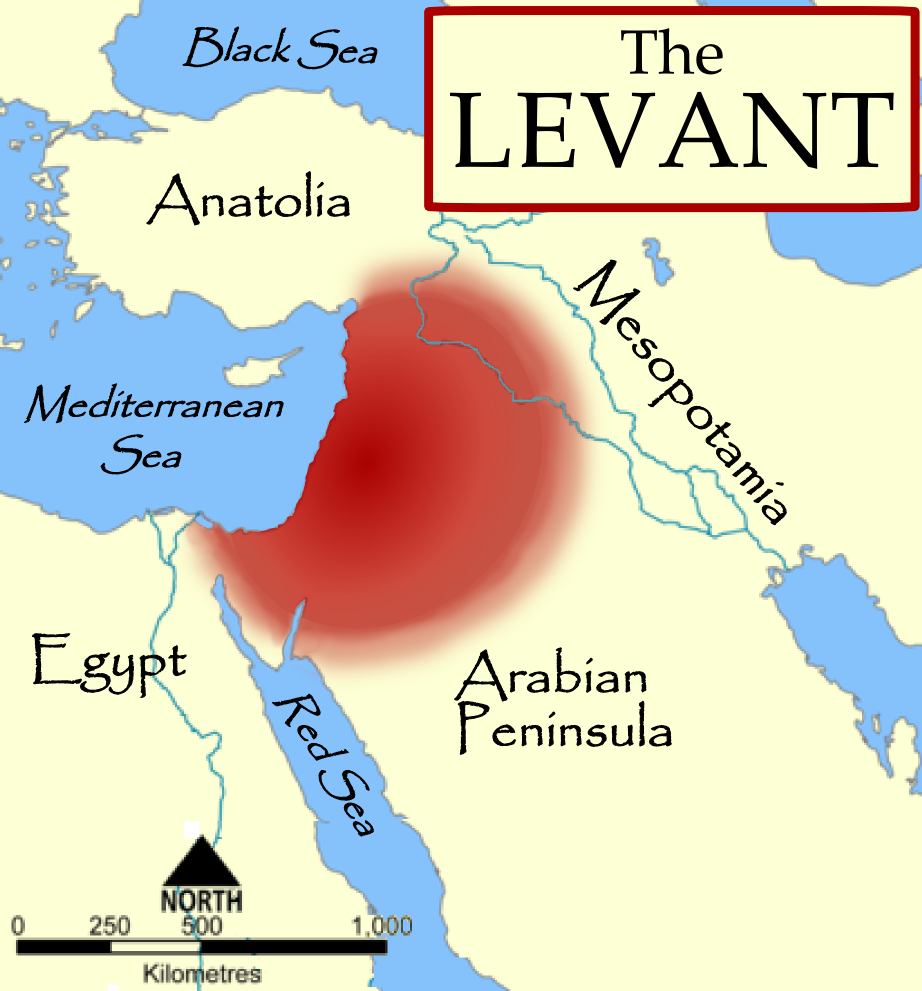
| İzahThe Levant 3.png | The Levant, based on a NormanEinstein's Image:Fertile Crescent blank base map.png. |
| Tarix | 3 oktyabr 2006 (original upload date) |
| Mənbə | No machine-readable source provided. Own work assumed (based on copyright claims). |
| Müəllif | No machine-readable author provided. MapMaster assumed (based on copyright claims). |
| Digər versiyalar |
[redaktə]
|


References
- The American Heritage Dictionary of the English Language, Fourth Edition, Houghton Mifflin Company. "The countries bordering on the eastern Mediterranean Sea from Turkey to Egypt."
- Random House Dictionary, Random House, Inc. 2009. "The lands bordering the E shores of the Mediterranean Sea."
- Harris, William W. (2005) The Levant: a fractured mosaic, Markus Wiener, Second Edition, map p. 4, quote p. 1. "The Mediterranean littoral between the mountains of Cilicia and the Sinai peninsula."
- Oriental Institute, "Levant Site Map", University of Chicago, accessed 15 Dec 2009.
- Council for British Research in the Levant, "The CBRL is the British Academy sponsored society that supports research in the humanities and social sciences in the countries of the Levant: Cyprus, Israel, Jordan, Lebanon, Palestine and Syria, . . .", accessed 15 Dec 2009.
- Biblical and Levantine studies at UCLA, "The ancient cultures of the Levant are defined to include those of western Syria, Lebanon, Israel, Jordan, the Palestinian territories, the Egyptian Sinai, and Cyprus."
Lisenziya
I, the copyright holder of this work, hereby publish it under the following licenses:

|
Bu sənədi GNU Azad Sənədləşdirmə Lisenziyası, Versiya 1.2 və ya Azad Proqram Fondu tərəfindən nəşr olunan hər hansı sonrakı versiya şərtlərinə əsasən dəyişməz bölmələr, ön qapaq mətnləri və arxa qapaq mətnləri olmadan köçürmək, yayımlamaq və / və ya dəyişdirmək üçün icazə verilir; Lisenziyanın bir nüsxəsi GNU Azad Sənədləşdirmə Lisenziyası adlı hissəyə daxil edilmişdir.http://www.gnu.org/copyleft/fdl.htmlGFDLGNU Free Documentation Licensetruetrue |
| Bu fayl Creative Commons Attribution-Share Alike 3.0 Unported lisenziyası altında yayımlanır. | ||
| ||
| This licensing tag was added to this file as part of the GFDL licensing update.http://creativecommons.org/licenses/by-sa/3.0/CC BY-SA 3.0Creative Commons Attribution-Share Alike 3.0truetrue |
İstədiyiniz lisenziyanı seçə bilərsiniz.
derivative works
Derivative works of this file: The Levant-ar.png

|
This locator map image could be re-created using vector graphics as an SVG file. This has several advantages; see Commons:Media for cleanup for more information. If an SVG form of this image is available, please upload it and afterwards replace this template with
{{vector version available|new image name}}.
It is recommended to name the SVG file “The Levant 3.svg”—then the template Vector version available (or Vva) does not need the new image name parameter. |
Captions
Add a one-line explanation of what this file represents
Items portrayed in this file
təsvir edir
copyright status ingilis
copyrighted ingilis
3 oktyabr 2006
Faylın tarixçəsi
Faylın əvvəlki versiyasını görmək üçün gün/tarix bölməsindəki tarixlərə klikləyin.
| Tarix/Vaxt | Miniatür | Ölçülər | İstifadəçi | Şərh | |
|---|---|---|---|---|---|
| hal-hazırkı | 18:57, 11 oktyabr 2014 | | 922 × 991 (290 KB) | Spiridon Ion Cepleanu | Minor change : diffuse limits |
| 01:32, 4 oktyabr 2006 |  | 922 × 991 (237 KB) | MapMaster | Fixed some problems | |
| 03:54, 3 oktyabr 2006 |  | 922 × 991 (215 KB) | MapMaster | The Levant, based on a NormanEinstein's Image:Fertile Crescent blank base map.png. |
Faylın istifadəsi
Aşağıdakı səhifə bu faylı istifadə edir:
Faylın qlobal istifadəsi
Bu fayl aşağıdakı vikilərdə istifadə olunur:
- ast.wikipedia.org layihəsində istifadəsi
- ba.wikipedia.org layihəsində istifadəsi
- be.wikipedia.org layihəsində istifadəsi
- bg.wikipedia.org layihəsində istifadəsi
- ca.wikipedia.org layihəsində istifadəsi
- ckb.wikipedia.org layihəsində istifadəsi
- cs.wikipedia.org layihəsində istifadəsi
- cs.wiktionary.org layihəsində istifadəsi
- cv.wikipedia.org layihəsində istifadəsi
- de.wikipedia.org layihəsində istifadəsi
- diq.wikipedia.org layihəsində istifadəsi
- el.wiktionary.org layihəsində istifadəsi
- en.wikipedia.org layihəsində istifadəsi
- User:Dimadick
- Coele-Syria
- Talk:Pre-Islamic Arabia
- User:Zdunne
- User:Antoine75
- User:Teemu08
- User:MapMaster
- User:Gwilym84
- User:Zozoulia
- User:Motacilla
- User:James H. Jenkins
- User:Winter queen lizzie
- User:Aus Chia
- User:Imeriki al-Shimoni
- User:L.smithfield
- User:WisamFarouk
- Template:User Levantine History
- User:Jonathan48
- User:Hiram111
Bu faylın qlobal istifadəsinə baxın.
Metaməlumatlar
Bu faylda fotoaparat və ya skanerlə əlavə olunmuş məlumatlar var. Əgər fayl sonradan redaktə olunubsa, bəzi parametrlər bu şəkildə göstərilənlərdən fərqli ola bilər.
| Üfüqi xətt | 28,35 dpc |
|---|---|
| Şaquli xətt | 28,35 dpc |