File:FuehrerBunkerBerlinLocation.jpg
From Wikipedia, the free encyclopedia
Ficheru orixinal (700 × 830 píxels, tamañu de ficheru: 532 kB, triba MIME: image/jpeg)
Esti ficheru ye de Wikimedia Commons y puen usalu otros proyeutos. La descripción de la páxina de descripción del ficheru s'amuesa darréu.
| DescripciónFuehrerBunkerBerlinLocation.jpg |
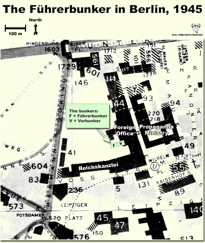
Map showing the locations of the Fuehrerbunker and Vorbunker in Berlin, 1945. |
| Data | |
| Fonte | Trabayu propiu |
| Autor | User:Dna-Dennis |
| Permisu (Cómo reutilizar esti ficheru) |
CC, see below. The map is completely unrestricted for any Wikipedia/Wikimedia project. |
Conteníu
Llicencia
- Ye llibre:
- pa compartir – pa copiar, distribuir y comunicar públicamente la obra
- pa remezclar – p'adautar la obra
- Baxo les condiciones siguientes:
- reconocimientu – Tienes de dar el créitu apropiáu, apurrir un enllaz a la llicencia ya indicar si realizasti dalgún cambéu. Puedes faelo de cualquier mou razonable ,pero non de manera que suxera l'encontu del autor pa ti o pal usu que faigas.
Resume
This is a map showing the locations of the Fuehrerbunker and Vorbunker in Berlin, 1945. These locations are not necessarily perfectly exact, but they are very probable. There were two bunkers which were connected - the Fuehrerbunker and the Vorbunker, and here are the links to my maps of these bunkers:
Information about the details of the bunkers is rather scarce, which is not strange, since the bunkers were secret. This map is based on the excellent research of Tom Posch (see below), who visited and photographed the remains from inside in 1988. He concluded that the map of the bunker in Cornelius Ryan's The Last Battle was incorrect, and a new, hand-drawn map of the Vorbunker was produced by Tom Posch.
Notes on the location of the bunkers
The Fuehrerbunker, built in 1943/44, was located 8-17 meters beneath the Reichskanzlei garden, approx. 120 meters north of the new Reichskanzlei building, which had the address Vossstrasse 6. The Führerbunker was located somewhat lower than the Vorbunker and west (or rather west-west-south) of it. The two bunkers were connected via sets of stairs set at right angles (not spiral).
Construction data (approximates)
- Material: Concrete
- Protective Wall Width: 220 cm
- Protective Roof Height: 280 cm
- Wall Width (interior): 15-20 cm
- Door Heights: 180-200 cm
- Door Widths: 120 cm
- Room Heights: 2-3 m
- Room Sizes: Varying; 3-5 m
References
The map is based on the following sources:
- Ramsey, Winston G. (editor) & Posch, Tom (researcher), The Berlin Führerbunker: The Thirteenth Hole, After the Battle archive copy at the Wayback Machine, No.61, Special Edition, Battle of Britain International Ltd, 1988, London
- Allied Intelligence Map of Key Buildings in Berlin (3rd edition, 1945)
- Ryan, Cornelius, The Last Battle (1966)
Regards,
Dennis Nilsson, Sweden.
If you wish to contact me, please leave a message on my talk page.
Pies
Elementos representados en este archivo
representa a
12 och 2007
Historial del ficheru
Calca nuna fecha/hora pa ver el ficheru como taba daquella.
| Data/Hora | Miniatura | Dimensiones | Usuariu | Comentariu | |
|---|---|---|---|---|---|
| actual | 02:37 12 och 2007 | | 700 × 830 (532 kB) | Dna-webmaster~commonswiki | minor fix |
| 02:06 12 och 2007 |  | 700 × 830 (530 kB) | Dna-webmaster~commonswiki | Uploaded new version | |
| 00:19 14 avi 2005 |  | 720 × 946 (442 kB) | Dna-webmaster~commonswiki | ||
| 08:30 14 pay 2005 |  | 720 × 946 (453 kB) | Dna-webmaster~commonswiki |
Usu del ficheru
La páxina siguiente usa esti ficheru:
Usu global del ficheru
Estes otres wikis usen esti ficheru:
- Usu en ar.wikipedia.org
- Usu en br.wikipedia.org
- Usu en el.wikipedia.org
- Usu en en.wikipedia.org
- Usu en es.wikipedia.org
- Usu en fi.wikipedia.org
- Usu en fr.wikipedia.org
- Usu en hu.wikipedia.org
- Usu en ja.wikipedia.org
- Usu en ru.wikipedia.org
Metadatos
Esti ficheru contien otra información, probablemente añadida pola cámara dixital o l'escáner usaos pa crealu o dixitalizalu.
Si'l ficheru se camudó dende'l so estáu orixinal, seique dalgunos detalles nun se reflexen completamente nel ficheru camudáu.
| Orientación | Normal |
|---|---|
| Resolución horizontal | 200 ppp |
| Resolución vertical | 200 ppp |
| Software usáu | Adobe Photoshop 7.0 |
| Data y hora de cambiu del ficheru | 04:45 12 och 2007 |
| Espaciu de color | Ensin calibrar |