ملف:East-Hem_1025ad.jpg
From Wikipedia, the free encyclopedia
الصوره الاصليه (3,240 × 1,903 بكسل حجم الفايل: 3.16 ميجابايت، نوع MIME: image/jpeg)
الملف دا من ويكيميديا كومنز و ممكن تستعمله المشاريع التانيه. الوصف بتاعه صفحة وصف الملف هناك معروض تحت..

|
هذه historical map الصورة / الصورتان باستعمال رسومات متجهية ملفات رسوميات شعاعية.
It is recommended to name the SVG file "East-Hem 1025ad.svg" - then the template Vector version available (or Vva) does not need the new image name parameter.
|
 | الصُّور الموجودة في file رُفعت بصيغة JPEG مع أنها تحتوي عناصر بيانات غير مرتبطة بالصُّور الضَّوئِيَّة. يُمكِن تخزين هذه المَعلُومات بطريقةٍ أكثرَ فعاليَّةً باستعمال صيغة PNG أو SVG. ارفع نسخة بصيغة PNG أو SVG لو أمكن مِن غير التَّشوهات النَّاتِجة عن الضَّغط في نسخة JPEG. بعد إنجاز ذلك، سِم نسخة JPEG بقالب {{Superseded|اسم الصورة الجديدة.الصيغة}} ثُمَّ أزل هذا القالب. لا يُستعمل هذا القالب مع الصُّور الضَّوئيَّة أو الصُّور المَمسُوحة ضوئيَّاً. للمزيد من المعلومات انظر قالب {{BadJPEG}}. |  |
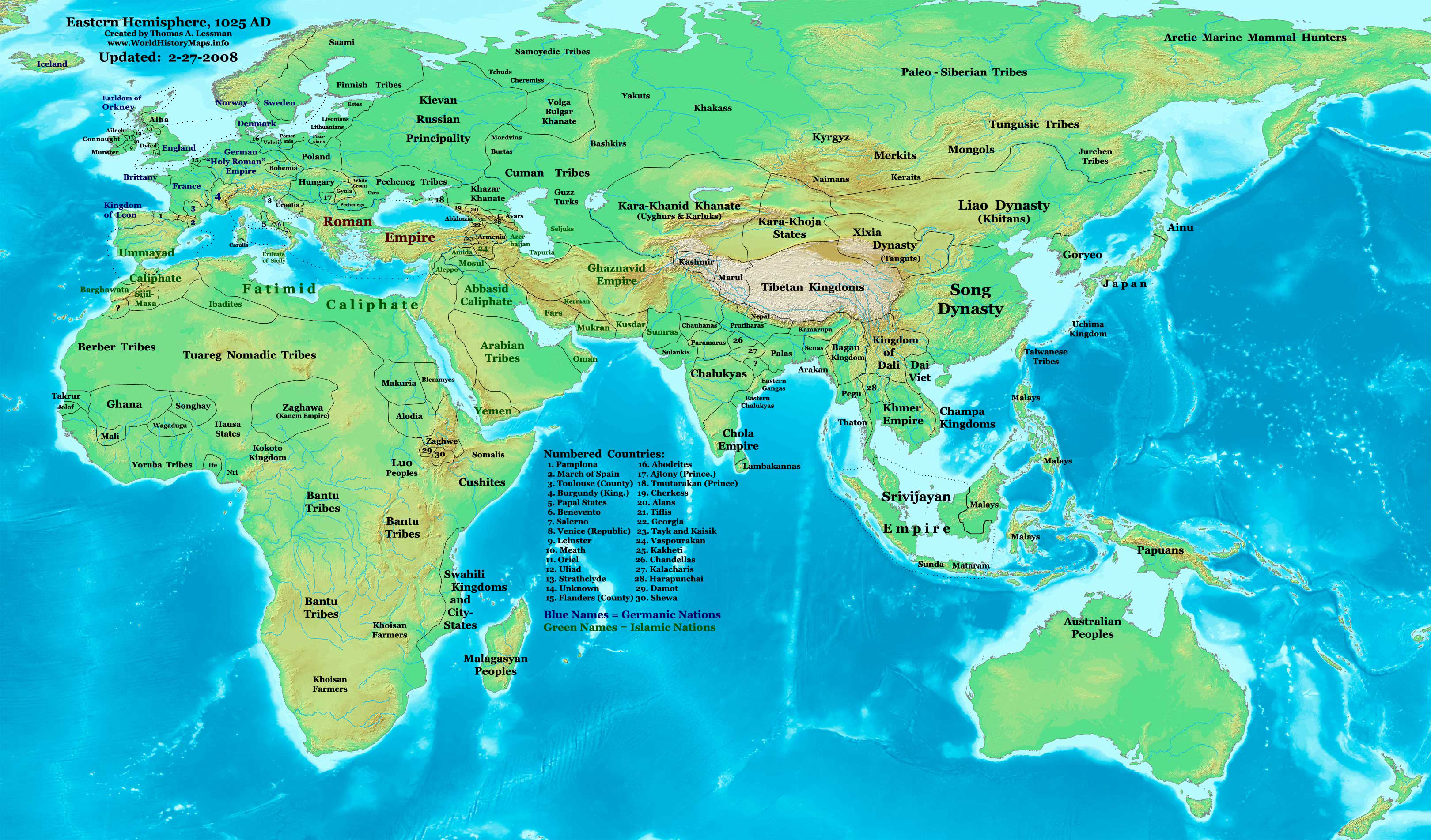
| وصفEast-Hem 1025ad.jpg | Eastern Hemisphere in 1025 AD. |
| مصدر | self-made (For reference information, see the Map Source References section below.) |
| مؤلف | Thomas Lessman (Contact!) |
| سماح (إعادة استخدام الملف ده) |
أنا، صاحب حقوق التأليف والنشر لهذا العمل، أنشر هذا العمل تحت الرخصة التالية: الملف ده مترخص حسب رخصة المشاع الإبداعى نسبة المصنف للى مألفه - المشاركة بالمثل 3.0 العامه
|
| إصدارات أخرى | see East-Hem_1025ad.jpg file history on Wikipedia. |
المحتويات
Map Summary
Original Source URL: http://www.thomaslessman.com/History/images/East-Hem_1025ad.jpg.
This map of the Eastern Hemisphere in 1025 AD was created by Thomas Lessman, based on information from the sources listed below. This map is free for educational use (see Permission info above). When using this map, please mention that it is available for free at www.WorldHistoryMaps.info.
Map Source References
- Remember, sources often conflict with each other. This map is only as accurate as the information that is available to me. To report any errors or to help further this work, please click here, or email Thomas Lessman at talessman@yis.us
References for information contained in this map:
1. Borders of Europe are mostly derived from the www.Euratlas.com map of Europe in 1000 AD.
- (Please note: Bogomolov.PL has done a great job of showing me possible discrepancies in my north European borders compared to this source, due to the differences in the geographical layout of the maps.)
2. Borders of Asian countries derive from various Wikipedia articles and Google history map searches.
3. Fringe areas like Africa, Australia, Siberia, etc. derive from various articles in Wikipedia.
4. Much of the information in this map was cross-checked with Bruce Gordon's Regnal Chronologies.
Other Maps by Thomas Lessman
| Maps of the eastern hemisphere showing history
Bold dates are available on Wikimedia or Wikipedia. | ||
| Primeval | ||
| Ancient
|
·| 600 BC | 550 BC | 527 BC | 500 BC |
400 BC | ·| 1 AD | 50 AD | 100 AD | 200 AD | 300 AD | | |
| Medieval |
·| 500 AD | 565 AD | 600 AD | 700 AD | | |
| Modern |
·| 1500 AD | · * For historical maps of the whole world, | |
| history links talk edit view | ||
سجلُّ الرَّفع الأصيل
- 2008-01-21 22:17 Talessman 3240×1903×8 (795129 bytes) Corrected borders of Southeast Asia, Africa, Scandinavia, and added more info for East Asia and Africa.
- 2007-12-05 20:33 Talessman 3240×1903×8 (774637 bytes) Corrected borders for Mongolia, added names of smaller countries (with numbered legend), added more info for Africa, corrected information for Indonesia.
- 2007-11-09 15:14 Talessman 3240×1903×8 (727501 bytes) Corrected borders of Srivijaya, Sudan, and Ethiopia, also added info on other African tribes and nations, also added info for far eastern islands.
- 2007-09-26 16:26 Talessman 2880×1692×8 (571380 bytes) Author: Thomas A. Lessman. Source URL: http://www.ThomasLessman.com/History/images/East-Hem_1025ad.jpg. Image was created by me (Thomas Lessman) based on historical information located on Wikipedia, as well as information from maps located in Wikipedia an
- 2007-09-12 21:54 Talessman 2880×1692×8 (558662 bytes) Author: Thomas A. Lessman. Source URL: http://www.ThomasLessman.com/History/images/East-Hem_1025ad.jpg. Image was created by me (Thomas Lessman) based on historical information located on Wikipedia, as well as information from maps located in Wikipedia an
الشروحات
العناصر المصورة في هذا الملف
يُصوِّر العربية
قيمة ما بدون عنصر ويكيداتا
تاريخ الفايل
اضغط على الساعه/التاريخ علشان تشوف الفايل زى ما كان فى الوقت ده.
| الساعه / التاريخ | صورة صغيرة | ابعاد | يوزر | تعليق | |
|---|---|---|---|---|---|
| دلوقتي | 11:09، 16 يناير 2009 | | 3,240 × 1,903 (3.16 ميجابايت) | Ukabia | {{Information |Description= |Source= |Date= |Author= |Permission= |other_versions= }} |
| 21:27، 9 مايو 2008 |  | 3,240 × 1,903 (778 كيلوبايت) | Talessman | {{Information |Description=Eastern Hemisphere in 1025 AD. |Source=self-made |Author=User:Talessman |Permission={{self|cc-by-sa-3.0}} }} |
استخدام الفايل
ال1 صفحة دى فيها وصله للفايل ده:
استخدام الملف العام
الويكيات التانيه دى بتستخدم الفايل ده:
- الاستخدام ف ar.wikipedia.org
- الاستخدام ف azb.wikipedia.org
- الاستخدام ف be.wikipedia.org
- الاستخدام ف bs.wikipedia.org
- الاستخدام ف ceb.wikipedia.org
- الاستخدام ف de.wikiversity.org
- الاستخدام ف en.wikipedia.org
- 11th century
- User:Tompw/sandbox10
- User:Talessman/Maps
- User talk:Talessman/Maps
- User:Benjamin Trovato/sandbox
- List of states during the Middle Ages
- List of political entities in the 11th century
- User:Navops47/sandbox10
- List of countries by population in 1000
- Champa–Đại Cồ Việt war (982)
- User:Falcaorib/Ancient East Hemisphere
- الاستخدام ف es.wikipedia.org
- الاستخدام ف fa.wikipedia.org
- الاستخدام ف fr.wikipedia.org
- الاستخدام ف gl.wikipedia.org
- الاستخدام ف he.wikipedia.org
- الاستخدام ف hu.wikipedia.org
- الاستخدام ف io.wikipedia.org
- الاستخدام ف lt.wikipedia.org
- الاستخدام ف mk.wikipedia.org
- الاستخدام ف mr.wikipedia.org
- الاستخدام ف my.wikipedia.org
- الاستخدام ف pnb.wikipedia.org
- الاستخدام ف ps.wikipedia.org
- الاستخدام ف ro.wikipedia.org
- الاستخدام ف rue.wikipedia.org
- الاستخدام ف ru.wikipedia.org
- الاستخدام ف shn.wikipedia.org
- الاستخدام ف si.wikipedia.org
- الاستخدام ف sv.wikipedia.org
- الاستخدام ف sw.wikipedia.org
- الاستخدام ف tg.wikipedia.org
- الاستخدام ف th.wikipedia.org
- الاستخدام ف tl.wikipedia.org
- الاستخدام ف ur.wikipedia.org
اعرض استخدام عام اكتر للملف ده.
بيانات ميتا
الملف ده فيه معلومات إضافيه، غالبا ما تكون أضيفت من الديجيتال كاميرا أو السكانر ح الضوئى المستخدم فى نقل الملف للكومبيوتر.
إذا كان الملف اتعدل عن حالته الأصلية، فبعض التفاصيل مش ها تعبر عن الملف المعدل.
| التوجيه | عادي |
|---|---|
| الدقة الأفقية | 72 نقطة لكل بوصة |
| الدقة الرأسية | 72 نقطة لكل بوصة |
| البرمجيات المستخدمة | Adobe Photoshop CS3 Macintosh |
| تاريخ و وقت تغيير الملف | 11:07، 16 يناير 2009 |
| فرق اللون | غير معاير |