a Gmaind i da bündner Herrschaft From Wikipedia, the free encyclopedia
Fläsch isch e Gmaind vom Kanton Graubünde.
| Fläsch | |
|---|---|
 | |
| Basisdate | |
| Staat: | Schwiiz |
| Kanton: | Graubünde (GR) |
| Region: | Landquart |
| BFS-Nr.: | 3951 |
| Poschtleitzahl: | 7306 |
| Koordinate: | 757711 / 210469 |
| Höchi: | 528 m ü. M. |
| Flächi: | 19.94 km² |
| Iiwohner: | 855 (31. Dezämber 2022)[1] |
| Website: | www.flaesch.ch |
 Fläsch | |
| Charte | |
 | |
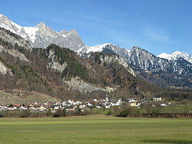
D Gmaind lyt in der Region Landquart und i dr «Büntner Herschaft». Si isch d Gmaind vom Bünderland, wo am wytischte im Norde lyt, das isch im Rhydaal unde, näbet Mäiefäld und wisawi vo Bad Ragaz, wo zum Kanton Sangale ghört. Gäge Norde chunt me vo Fläsch us übere Fläscher Bärg und d Sankt Luzisteig uf Balzers im Fürstetum Liechtestein.
Änet em Falknis het Fläsch es grosses Alpegebiet mit dr Sarinaalp. Dr diräkt Wääg vo Fläsch zu däm abglägne Fläscher Alpenareaal goot über s Gebiet vo Mäiefäld und über ne stotzige Bärghang zum ”Fläscher Fürggli”, wo uf 2247 Meter oben isch.
Dr Ort isch ane 831 s erschte Mol erwäänt.
Sid 1509 het Fläsch als Undertaneland zu de drei Bünd ghört, und ane 1803 isch s en eigeti Gmaind worde.
Seamless Wikipedia browsing. On steroids.
Every time you click a link to Wikipedia, Wiktionary or Wikiquote in your browser's search results, it will show the modern Wikiwand interface.
Wikiwand extension is a five stars, simple, with minimum permission required to keep your browsing private, safe and transparent.