Datei:World_1898_empires_colonies_territory.png
From Wikipedia, the free encyclopedia
Originaldatei (1.560 × 624 Pixel, Dateigrößi: 45 KB, MIME-Typ: image/png)
| Die Datei un d Informatione derzue were us em zäntrale Mediearchiv Wikimedia Commons (Allmänd) iibunde. | Zur Bschriibigssite uff de Allmänd |
| BschryybigWorld 1898 empires colonies territory.png |
|
||||||||||||||||
| Datum | 9. Juni 2006 (Original-Hochladedatum) | ||||||||||||||||
| Quälle | No machine-readable source provided. Own work assumed (based on copyright claims). | ||||||||||||||||
| Urheber | No machine-readable author provided. Roke~commonswiki assumed (based on copyright claims). | ||||||||||||||||
.jpg)
._LOC_2001620596.jpg)

|
Dieses Bild des Typs Historical map sollte als Vektorgrafik im SVG-Format neu erstellt werden. Vektorformate haben zahlreiche Vorteile; weitere Information unter Commons:Media for cleanup. Wenn dir eine SVG-Version dieses Bildes vorliegt, so lade diese bitte hoch. Nach dem Hochladen der Datei ist diese Vorlage auf der aktuellen Bildbeschreibungsseite durch die Vorlage {{Vector version available}}, oder kürzer {{Vva}}, zu ersetzen. Es ist empfohlen die neue SVG-Datei „World 1898 empires colonies territory.svg“ zu nennen – dann benötigt die Vorlage vector version available (bzw. vva) keinen Parameter.
|
Inhaltsverzeichnis
Bschryybig
Español
Imperios del mundo y sus colonias, (antes de la Guerra Española-Estadounidense, la Guerra de los Boxer y la Guerra de los Boer, derivado de Image:BlankMap-World-WWI.PNG
English
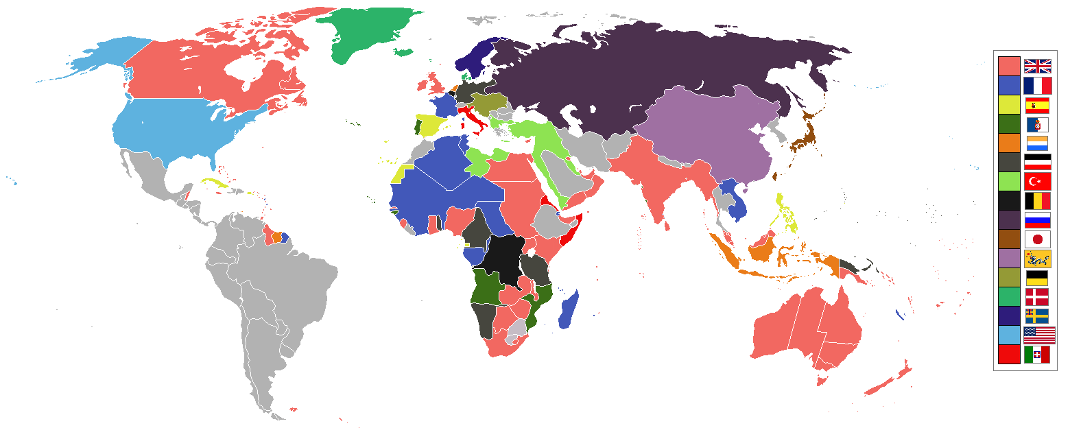
World empires and colonies 1898, (just before the Spanish–American War, Boxer Rebellion and Boer War), derived from Image:BlankMap-World-WWI.PNG
Tiếng Việt
Français
Empires et colonies du monde 1898, (juste avant la guerre hispano-américaine, la révolte des Boxers et la guerre des Boers, dérivée de Image:BlankMap-World-WWI.PNG).
عربي
مستوحاة من Image:BlankMap-World-WWI.PNG
中文 (繁體)
中文 (简体)
Deutsch
Italiano
Bahasa Indonesia
Imperium dan koloni di dunia pada tahun 1898 (sebelum Perang Spanyol-Amerika, Pemberontakan Boxer dan Perang Boer).
Македонски
Империи и колонии во 1898 г., (веднаш пред Шпанско-американската војна, Боксерското востание и Бурската војна), создадено врз основа на Image:BlankMap-World-WWI.PNG
Nederlands
Wereldrijken en kolonies 1898, (net voor de Spaans-Amerikaanse oorlog, Boxer opstand en Boerenoorlog).
Polski
Imperia i kolonie świata w 1898, (przed wojną amerykańsko-hiszpańską, powstaniem bokserów i wojnami burskimi), na podstawie Image:BlankMap-World-WWI.PNG
Português
Русский
Українська
한국어
1898년 세계의 각 제국과 국가들을 나타낸 지도이다. (미국-스페인 전쟁, 의화단 운동, 보어 전쟁 전의 상황이다.)
日本語
עברית
gurupletos
See also
| Maps of world history | |
| BC | |
|
| |
| AD |
1 · 50 · 100 · 200 · 250 · 300 · 400 · 500 · 700 · 750 · 820 · 900 · 1200 · 1500 · 1556 · 1648 · 1700 · 1750 · 1815 · 1859 · 1871 · 1914 · 1935 · 1954 · 1989 · 2000 · |
|
Maps of colonization history | |
|
see also: Eastern Hemisphere only maps template (1300BC-1500AD) | |
| (this template: · view · discuss ) | |
Lizänzierig

|
Des Dokumänt derf kopiert, verbreitet un/oder bearbeitet wäre unter dr Bedingige vu dr GNU-Lizänz fir freji Dokumäntation, Version 1.2 oder ere spetere Version, vereffetligt dur Free Software Foundation. S het keini uuveränderlige Abschnitt, kei vordere Umschlagstext un kei hindere Umschlagstext. E Kopii vu dr Lizänz isch verfiegbar im Abschnitt GNU-Lizänz fir freji Dokumäntation.http://www.gnu.org/copyleft/fdl.htmlGFDLGNU Free Documentation Licensetruetrue |
| Die Datei isch lizänziert unter dr Creative-Commons-Lizenz Namensnännig – Wytergab unter glyche Bedingige 3.0 nit portiert. | ||
| ||
| Die Lizänzmarkierig isch wäg em GFDL-Lizänzupdate zuegfiegt wore.http://creativecommons.org/licenses/by-sa/3.0/CC BY-SA 3.0Creative Commons Attribution-Share Alike 3.0truetrue |
| Annotations InfoField | This image is annotated: View the annotations at Commons |
Capitanía General de Filipinas
Kurzbeschreibungen
Urheberrechtsstatus Tüütsch
urheberrechtlich geschützt Tüütsch
9. Juni 2006
MIME-Typ Tüütsch
image/png
Dateiversione
Klick uf e Zytpunkt zu aazeige, wie s dert usgsäh het.
| Version vom | Vorschaubild | Mäß | Benutzer | Kommentar | |
|---|---|---|---|---|---|
| aktuell | 11:16, 8. Nov. 2021 | 1.560 × 624 (45 KB) | Randomastwritter | jubaland | |
| 09:24, 3. Jul. 2019 | 1.560 × 624 (40 KB) | Insider | the border between East Africa Protectorate and Italian Somaliland per User talk:Insider#File:World 1898 empires colonies territory.png | ||
| 09:18, 31. Jan. 2019 | 1.560 × 624 (40 KB) | Insider | Arkticheskiy Institut Islands, Izvestiy TSIK Islands, Kirov Islands, Sverdrup Island, Russky Island, Uyedineniya Island, Vize Island and Ushakov Island also is terra nullis at 1898 | ||
| 12:34, 30. Jan. 2019 | 1.560 × 624 (40 KB) | Insider | In 1898, Grumant, Jan Mayen Island, Severnaya Zemlya, Franz Josef Land, Wrangel island was terra nullius. Fixed Aleutian and Solovki islands. | ||
| 17:56, 6. Aug. 2018 | 1.560 × 624 (45 KB) | Lord Obvious | |||
| 14:04, 12. Apr. 2016 | 1.560 × 624 (45 KB) | The- | Minor fixes | ||
| 23:59, 11. Apr. 2016 | 1.560 × 624 (45 KB) | The- | Minor fixes | ||
| 23:52, 11. Apr. 2016 | 1.560 × 624 (44 KB) | The- | More accurate map | ||
| 04:59, 3. Aug. 2014 | 1.554 × 628 (41 KB) | Alvin Lee | Correcting the boundaries of Russia and China | ||
| 20:36, 23. Okt. 2012 | 1.554 × 628 (62 KB) | Franco310397 | Spanish presence in Micronesia (Oceania) included in the Captaincy General of the Philippines. In the Caroline Islands and the Mariana Islands. |
Verwändig vu dr Datei
Di folgende Sytene händ en Link zu dem Bildli:
Wältwyti Dateinutzig
Die andere Wikis bruche die Datei:
- Gebruch uf af.wikipedia.org
- Gebruch uf am.wikipedia.org
- Gebruch uf an.wikipedia.org
- Gebruch uf ar.wikipedia.org
- Gebruch uf av.wikipedia.org
- Gebruch uf az.wikipedia.org
- Gebruch uf ba.wikipedia.org
- Gebruch uf bg.wikipedia.org
- Gebruch uf bn.wikipedia.org
- Gebruch uf bs.wikipedia.org
- Gebruch uf btm.wikipedia.org
- Gebruch uf ca.wikipedia.org
- Gebruch uf ceb.wikipedia.org
- Gebruch uf ce.wikipedia.org
- Gebruch uf cs.wikipedia.org
- Gebruch uf da.wikipedia.org
- Gebruch uf de.wikipedia.org
- Gebruch uf de.wiktionary.org
- Gebruch uf el.wikipedia.org
- Gebruch uf en.wikipedia.org
Wältwyti Verwändig vu däre Datei aaluege.
Metadate
Die Datei het wyteri Informatione, allwäg vor Digitalkamera oder vom Scanner wo se het gschaffe.
We die Datei isch veränderet worde, de cha's sy, das die zuesätzlechi Information für di verändereti Datei nümm richtig zuetrifft.
| Horizontali Uflesig | 47,24 dpc |
|---|---|
| Vertikali Uflesig | 47,24 dpc |
| Spycherzytpunkt | 07:23, 3. Jul. 2019 |