Lêer:Zealandia_topography.jpg
From Wikipedia, the free encyclopedia
Grootte van hierdie voorskou: 516 × 600 piksels. Ander resolusies: 206 × 240 piksels | 413 × 480 piksels | 661 × 768 piksels | 881 × 1 024 piksels | 1 391 × 1 617 piksels.
Oorspronklike lêer (1 391 × 1 617 piksels, lêergrootte: 1,34 MG, MIME-tipe: image/jpeg)
Hierdie lêer kom vanaf Wikimedia Commons en kan ook in ander projekte gebruik word. Die beskrywing op die lêer se inligtingsblad word hieronder weergegee.
Opsomming
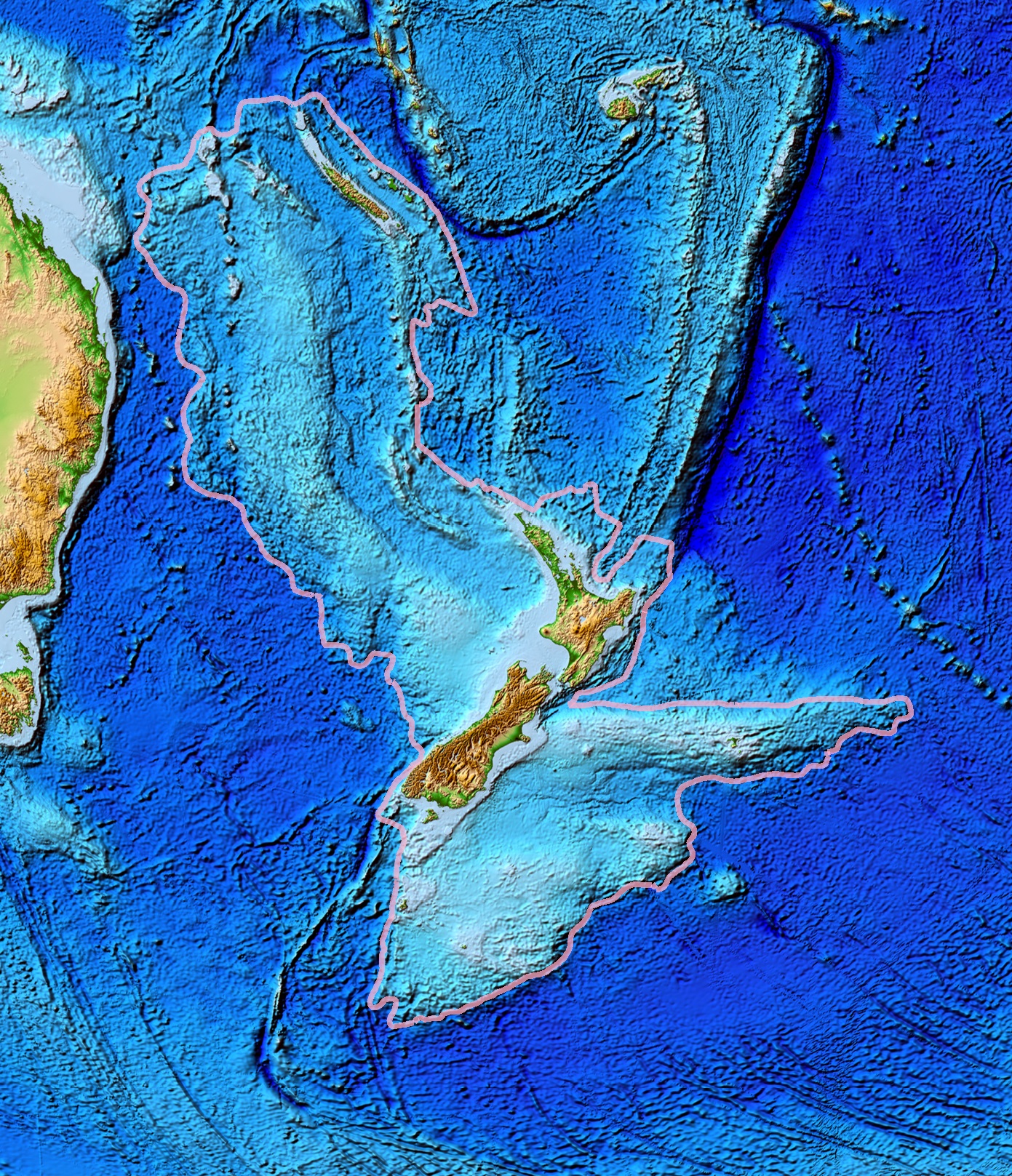
| BeskrywingZealandia topography.jpg | Topographical map of the Zealandia continent. |
| Datum | |
| Bron | Ultimate source: ETOPO2v2, a digital database of seafloor and land elevations. Actually cropped from Image:Pacific_elevation.jpg. |
| Outeur | World Data Center for Geophysics & Marine Geology (Boulder, CO), National Geophysical Data Center, NOAA |
| Toestemming (Hergebruik van die lêer) |
NOAA, public domain |
| Ander weergawes | Image:Pacific_elevation.jpg, here cropped to focus on Zealandia. |
Lisensiëring
| Public domainPublic domainfalsefalse |
This image is in the public domain because it contains materials that originally came from the U.S. National Oceanic and Atmospheric Administration, taken or made as part of an employee's official duties.
العربية ∙ čeština ∙ Deutsch ∙ Zazaki ∙ English ∙ español ∙ eesti ∙ suomi ∙ français ∙ hrvatski ∙ magyar ∙ italiano ∙ 日本語 ∙ 한국어 ∙ македонски ∙ മലയാളം ∙ Plattdüütsch ∙ Nederlands ∙ polski ∙ português ∙ română ∙ русский ∙ sicilianu ∙ slovenščina ∙ Türkçe ∙ Tiếng Việt ∙ 简体中文 ∙ 繁體中文 ∙ +/− |
Captions
Add a one-line explanation of what this file represents
Zealandia topography
Zealandia kıtasının topografik haritası
Items portrayed in this file
uitbeelding
submerged continent Engels
Junie 2006
media type Engels
image/jpeg
Lêergeskiedenis
Klik op die datum/tyd om te sien hoe die lêer destyds gelyk het.
| Datum/Tyd | Duimnael | Dimensies | Gebruiker | Opmerking | |
|---|---|---|---|---|---|
| huidig | 13:24, 28 Maart 2017 | | 1 391 × 1 617 (1,34 MG) | Bogomolov.PL | continent limits with pink |
| 01:44, 13 Maart 2007 |  | 573 × 677 (143 KG) | Avenue | == Summary == {{Information |Description=Topographical map of the Zealandia continent. |Source=Source: [http://www.ngdc.noaa.gov/mgg/image/2minrelief.html]. Actually cropped from Image:Pacific_elevation.jpg. |Date=June 2006 |Permissio |
Lêergebruik
Die volgende bladsy gebruik dié lêer:
Globale lêergebruik
Die volgende ander wiki's gebruik hierdie lêer:
- Gebruik in ang.wikipedia.org
- Gebruik in ar.wikipedia.org
- Gebruik in ast.wikipedia.org
- Gebruik in az.wikipedia.org
- Gebruik in bg.wikipedia.org
- Gebruik in bn.wikipedia.org
- Gebruik in ca.wikipedia.org
- Gebruik in el.wikipedia.org
- Gebruik in en.wikipedia.org
- Gebruik in eo.wikipedia.org
- Gebruik in es.wikipedia.org
- Gebruik in et.wikipedia.org
- Gebruik in eu.wikipedia.org
- Gebruik in fa.wikipedia.org
- Gebruik in fi.wikipedia.org
- Gebruik in fr.wikipedia.org
- Gebruik in gl.wikipedia.org
- Gebruik in he.wikipedia.org
- Gebruik in hi.wikipedia.org
- Gebruik in hr.wikipedia.org
- Gebruik in hu.wikipedia.org
- Gebruik in hy.wikipedia.org
- Gebruik in ia.wikipedia.org
- Gebruik in id.wikipedia.org
- Gebruik in incubator.wikimedia.org
- Gebruik in is.wikipedia.org
- Gebruik in it.wikipedia.org
- Gebruik in ja.wikipedia.org
- Gebruik in ka.wikipedia.org
- Gebruik in kk.wikipedia.org
- Gebruik in ko.wikipedia.org
- Gebruik in li.wikipedia.org
Wys meer globale gebruik van die lêer.
Ontsluit van "https://af.wikipedia.org/wiki/Lêer:Zealandia_topography.jpg"