Lêer:Barents_Sea_map.png
From Wikipedia, the free encyclopedia
Grootte van hierdie voorskou: 657 × 600 piksels. Ander resolusies: 263 × 240 piksels | 526 × 480 piksels | 841 × 768 piksels | 1 187 × 1 084 piksels.
Oorspronklike lêer (1 187 × 1 084 piksels, lêergrootte: 654 KG, MIME-tipe: image/png)
Hierdie lêer kom vanaf Wikimedia Commons en kan ook in ander projekte gebruik word. Die beskrywing op die lêer se inligtingsblad word hieronder weergegee.
Opsomming
| BeskrywingBarents Sea map.png |
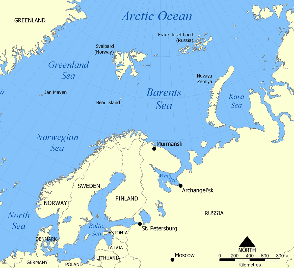
English: The location of the Barents Sea north of Russia and Norway, and the surrounding seas and islands. Also includes political borders with their corresponding nation-states listed. |
| Datum | |
| Bron | Eie werk |
| Outeur | NormanEinstein |
| Ander weergawes |
[wysig]
|


Lisensiëring
Ek, die outeursreghouer van hierdie werk, publiseer dit onder die volgende lisensie:

|
Toestemming word verleen tot die kopiëring, verspreiding en/of wysiging van hierdie dokument onder die voorwaardes van die GNU-lisensie vir vrye dokumentasie, weergawe 1.2 of enige latere weergawe uitgegee deur die Stigting vir Vrye Sagteware, sonder Invariante Dele, geen Voorbladtekste en geen Agterbladtekste. 'n Kopie van hierdie lisensie is ingesluit in die afdeling getiteld GNU Free Documentation License.http://www.gnu.org/copyleft/fdl.htmlGFDLGNU Free Documentation Licensetruetrue |
| Hierdie lêer is gelisensieer onder die Creative Commons Erkenning-Insgelyks Deel 3.0 Onoorgedraagde lisensie. | ||
| ||
| This licensing tag was added to this file as part of the GFDL licensing update.http://creativecommons.org/licenses/by-sa/3.0/CC BY-SA 3.0Creative Commons Attribution-Share Alike 3.0truetrue |
U kan die lisensie van u keuse kies.
Captions
Add a one-line explanation of what this file represents
The location of the Barents Sea
Barents Sea
Items portrayed in this file
uitbeelding
some value
source of file Engels
25 November 2005
media type Engels
image/png
checksum Engels
f7a5ee6d4b4514fe0c001142a4b0f0bf17f69b6f
data size Engels
669 295 greep
height Engels
1 084 pieksel
width Engels
1 187 pieksel
Lêergeskiedenis
Klik op die datum/tyd om te sien hoe die lêer destyds gelyk het.
| Datum/Tyd | Duimnael | Dimensies | Gebruiker | Opmerking | |
|---|---|---|---|---|---|
| huidig | 20:52, 29 Maart 2012 | | 1 187 × 1 084 (654 KG) | Ras67 | cropped |
| 06:11, 5 Februarie 2006 |  | 1 200 × 1 098 (680 KG) | Berkut~commonswiki | pngout-ed (13% file size reduction) | |
| 16:40, 25 November 2005 |  | 1 200 × 1 098 (781 KG) | NormanEinstein | This map shows the location of the Barents Sea north of Russia and Norway, and the surrounding seas and islands. Created by NormanEinstein, November 25, 2005. {{GFDL-self}} Category:Maps of seas |
Lêergebruik
Die volgende 2 bladsye gebruik dié lêer:
Globale lêergebruik
Die volgende ander wiki's gebruik hierdie lêer:
- Gebruik in ar.wikipedia.org
- Gebruik in arz.wikipedia.org
- Gebruik in ast.wikipedia.org
- Gebruik in azb.wikipedia.org
- Gebruik in bcl.wikipedia.org
- Gebruik in be-tarask.wikipedia.org
- Gebruik in bg.wikipedia.org
- Gebruik in bn.wikipedia.org
- Gebruik in bs.wikipedia.org
- Gebruik in ca.wikipedia.org
- Gebruik in cs.wikipedia.org
- Gebruik in cs.wikinews.org
- Gebruik in da.wikipedia.org
- Gebruik in de.wiktionary.org
- Gebruik in el.wikipedia.org
- Gebruik in en.wikipedia.org
- Barents Sea
- User:NormanEinstein/gallery
- Keith Jessop
- Convoy PQ 1
- Convoy PQ 2
- Convoy PQ 18
- Fishing industry in Russia
- Operation Fritham
- List of Russian explorers
- Convoy PQ 12
- Convoy PQ 11
- Convoy PQ 9/10
- Convoy PQ 8
- Arctic naval operations of World War II
- Convoy QP 14
- List of oil and gas fields of the Barents Sea
- Operation Orator
- Operation Gearbox
- Operation Gearbox II
- Convoy QP 1
- Atlantification of the Arctic
- Gebruik in en.wikisource.org
- Gebruik in en.wiktionary.org
- Gebruik in eo.wikipedia.org
- Gebruik in es.wikipedia.org
- Gebruik in eu.wikipedia.org
- Gebruik in fa.wikipedia.org
- Gebruik in fi.wikipedia.org
- Gebruik in fo.wikipedia.org
- Gebruik in fr.wikipedia.org
Wys meer globale gebruik van die lêer.
Ontsluit van "https://af.wikipedia.org/wiki/Lêer:Barents_Sea_map.png"