
Tecklenburg
Town in North Rhine-Westphalia, Germany / From Wikipedia, the free encyclopedia
For the surname, see Tecklenburg (surname).
Tecklenburg (German: [ˈtɛklənˌbʊʁk] ⓘ) is a town in the district of Steinfurt, in North Rhine-Westphalia, Germany. Its name comes from the ruined castle around which it was built. The town is situated on the Hermannsweg hiking trail.
Quick Facts Country, State ...
Tecklenburg | |
|---|---|
 | |
 Coat of arms | |
Location of Tecklenburg within Steinfurt district 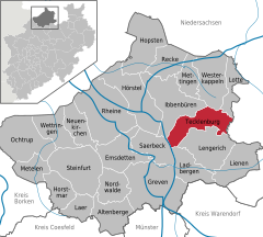 | |
 Tecklenburg  Tecklenburg | |
| Coordinates: 52°13′10″N 7°48′45″E | |
| Country | Germany |
| State | North Rhine-Westphalia |
| Admin. region | Münster |
| District | Steinfurt |
| Subdivisions | 17 |
| Government | |
| • Mayor (2020–25) | Stefan Streit[1] (SPD) |
| Area | |
| • Total | 70.37 km2 (27.17 sq mi) |
| Highest elevation | 201 m (659 ft) |
| Lowest elevation | 122 m (400 ft) |
| Population (2022-12-31)[2] | |
| • Total | 9,288 |
| • Density | 130/km2 (340/sq mi) |
| Time zone | UTC+01:00 (CET) |
| • Summer (DST) | UTC+02:00 (CEST) |
| Postal codes | 49545 |
| Dialling codes | 05482 |
| Vehicle registration | ST, BF, TE |
| Website | www.tecklenburg.de |
Close
The coat of arms shows an anchor and three seeblatts.