Portal:New Guinea
Wikipedia portal for content related to New Guinea / From Wikipedia, the free encyclopedia
Portal maintenance status: (April 2022)
|
Native name: Papua, Niugini, Niu Gini | |
|---|---|
 | |
| Geography | |
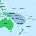
| Location | Oceania (Melanesia) |
| Archipelago | Melanesia and Malay Archipelago |
| Area | 785,753 km2 (303,381 sq mi) |
| Area rank | 2nd |
The New Guinea Portal
Introduction

New Guinea (Tok Pisin: Niugini; Hiri Motu: Niu Gini; Indonesian: Papua, fossilized Nugini, or historically Irian) is the world's second-largest island, with an area of 785,753 km2 (303,381 sq mi). Located in Melanesia in the southwestern Pacific Ocean, the island is separated from Australia by the 150-kilometre (81-nautical-mile; 93-mile) wide Torres Strait, though both landmasses lie on the same continental shelf, and were united during episodes of low sea level in the Pleistocene glaciations as the combined landmass of Sahul. Numerous smaller islands are located to the west and east. The island's name was given by Spanish explorer Yñigo Ortiz de Retez during his maritime expedition of 1545 due to the resemblance of the indigenous peoples of the island to those in the African region of Guinea. (Full article...)
Papua New Guinea, officially the Independent State of Papua New Guinea, is a country in Oceania that comprises the eastern half of the island of New Guinea and its offshore islands in Melanesia (a region of the southwestern Pacific Ocean north of Australia). It shares its only land border with Indonesia to the west and its other close neighbors are Australia to the south and the Solomon Islands to the east. Its capital, located on its southern coast, is Port Moresby. The country is the world's third largest island country, with an area of 462,840 km2 (178,700 sq mi). (Full article...)
Western New Guinea, also known as Papua, Indonesian New Guinea, and Indonesian Papua, is the western, formerly Dutch presently Indonesian, half of the island of New Guinea, granted to Indonesia in 1962. Given the island is alternatively named Papua, the region is also called West Papua (Indonesian: Papua Barat). (Full article...)
Selected article - load new batch
 Image 1
 Birds in Auri Island, Cendrawasih Bay NP
Teluk Cenderawasih National Park is the largest marine national park of Indonesia, located in Cenderawasih Bay, south-east of Bird's Head Peninsula. It includes the islands of Mioswaar, Nusrowi Island, Roon, Rumberpon, Anggrameos and Yoop. The park protects a rich marine ecosystem, with over 150 recorded coral species, for which it is considered a potential World Heritage Site. (Full article...)- Image 2

Morobe Province is a province on the northern coast of Papua New Guinea. The provincial capital and largest city is Lae. The province covers 33,705 km2, with a population of 674,810 (2011 census), and since the division of Southern Highlands Province in May 2012 it is the most populous province. It includes the Huon Peninsula, the Markham River, and delta, and coastal territories along the Huon Gulf. The province has nine administrative districts. At least 101 languages are spoken, including Kâte and Yabem language. English and Tok Pisin are common languages in the urban areas, and in some areas pidgin forms of German are mixed with the native language. (Full article...) - Image 3
 Copper ore concentrator undergoing construction, c. 1971
The Panguna mine is a large copper mine located in Bougainville, Papua New Guinea. Panguna represents one of the largest copper reserves in Papua New Guinea and in the world, having an estimated reserve of one billion tonnes of ore copper and twelve million ounces of gold. The mine has been closed since 1989 and has ceased all production. (Full article...) - Image 4
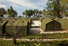
The Manus Regional Processing Centre, or Manus Island Regional Processing Centre (MIRCP), was one of a number of offshore Australian immigration detention facilities. The centre was located on the PNG Navy Base Lombrum (previously a Royal Australian Navy base called HMAS Tarangau) on Los Negros Island in Manus Province, Papua New Guinea.
It was originally established in 2001, along with Nauru Regional Processing Centre, as an "offshore processing centre" (OPC) as part of the Pacific Solution policy created by the Howard government. After falling into disuse in 2003, it was formally closed by the first Rudd government in 2008, but reopened by the Gillard government in 2012. As part of the PNG Solution by the second Rudd government, it was announced in July 2013 that those sent to PNG would never be resettled in Australia. After Tony Abbott became PM in a change of government a few months later, the government announced its Operation Sovereign Borders policy, aimed at stopping maritime arrivals of asylum seekers to Australia, commencing on 18 September 2013.
Many high-profile and ordinary Australians called for the centre to be closed and the men brought to Australia or resettled elsewhere, over the seven years of its existence. The United Nations High Commissioner for Refugees has cited the centre as an "indictment of a policy meant to avoid Australia's international obligations". It was formally closed on 31 October 2017; however hundreds of detainees ("transferees" according to the Australian government) refused to leave the centre and a stand-off ensued. On 23 November 2017, a few were resettled in the United States as part of a refugee swap deal. (Full article...) - Image 5
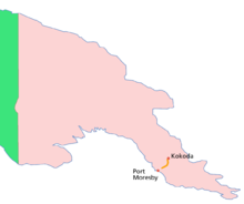
Location of the Kokoda Track within Papua New Guinea
The Kokoda Track or Trail is a single-file foot thoroughfare that runs 96 kilometres (60 mi) overland – 60 kilometres (37 mi) in a straight line – through the Owen Stanley Range in Papua New Guinea (PNG). The track was the location of the 1942 World War II battle between Japanese and Allied – primarily Australian – forces in what was then the Australian territory of Papua.
The track runs from Owers' Corner in Central Province, 50 kilometres (31 mi) east of Port Moresby, across rugged and isolated terrain which is only passable on foot, to the village of Kokoda in Oro Province. It reaches a height of 2,490 metres (8,169 ft) as it passes around the peak of Mount Bellamy. The track travels primarily through the land of the Mountain Koiari people.
Hot, humid days with intensely cold nights, torrential rainfall and the risk of endemic tropical diseases such as malaria make it a challenging trek. Hiking the trail normally takes between four and twelve days; the fastest recorded time is 16 hours 34 minutes. (Full article...) - Image 6Seth Jafeth Rumkorem (1933 – 2010) was a West Papuan military officer and independence activist. He chose to defect from the Indonesian Army to the Free Papua Movement (OPM) after witnessing electoral fraud and human rights abuses conducted by the former. He quickly became the leader of the movement's armed wing and was among the signatories of the proclamation of the Republic of West Papua.
He went into exile to Greece, after an attempt to secure weapons for OPM went wrong. He eventually relocated to the Netherlands, where he continued his activism until his death in 2010. (Full article...) - Image 7
 Marape in 2023
James Marape (born 24 April 1971) is a Papua New Guinean politician who has served as the prime minister of Papua New Guinea since May 2019. He has been a member of the National Parliament of Papua New Guinea since July 2007, representing the electorate of Tari-Pori Open in Hela Province in the New Guinea Highlands. He has held Cabinet Posts as Minister of Education (2008–2011), Minister of Finance (2012–2019), and Minister of Foreign Affairs (2023–present). Marape entered the 2022 elections under the banner of the Pangu Party and won more seats than any other party. He was therefore entitled to form the government. His new government was elected unopposed by the new parliament. (Full article...) - Image 8
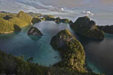 Panoramic view
Raja Ampat, or the Four Kings, is an archipelago located off of the northwest tip of Bird's Head Peninsula (on the island of New Guinea), Southwest Papua province, Indonesia. It comprises over 1,500 small islands, cays, and shoals around the four main islands of Misool, Salawati, Batanta, and Waigeo, and the smaller island of Kofiau.
The Raja Ampat archipelago straddles the equator and forms part of the Coral Triangle, an area of Southeast Asian seas containing the richest marine biodiversity on earth. The Coral Triangle itself is an approximate area west-southwest of the Philippines, east-northeast and southeast of the island of Borneo, and north, east and west of the island of New Guinea, including the seas in between. Thousands of species of marine organisms, from the tiniest cleaner shrimp and camouflaged pygmy seahorses to the majestic cetaceans and whale sharks, thrive in these waters.
Administratively, the archipelago is part of the province of Southwest Papua. Most of the islands constitute the Raja Ampat Regency, which was separated from Sorong Regency in 2004. The regency encompasses around 70,000 square kilometres (27,000 sq mi) of land and sea, of which 8,034.44 km2 constitutes the land area and has a population of 64,141 at the 2020 Census; the official estimate as at mid 2022 was 66,839. This excludes the southern half of Salawati Island, which is not part of this regency but instead constitutes the Salawati Selatan and Salawati Tengah Districts of Sorong Regency. (Full article...) - Image 9Bomberai Peninsula (Indonesian: Semenanjung Bomberai) is located in the Western New Guinea region. It is south of the Bird's Head Peninsula, and Bintuni Bay separates the two peninsulas. To the west lies the Sebakor Bay and to the south Kamrau Bay. On the southeast Arguni Bay lies between the peninsula and the Bird's Neck Isthmus.
Sabuda island lies off the western tip of the peninsula, and is separated from the mainland by Berau and Bintuni straits. (Full article...) - Image 10The People's National Congress is a political party in Papua New Guinea. Its former leader Bill Skate served as Prime Minister from 1997 to 1999 and as speaker of Parliament from 2002 to 2004. Skate died in 2006 and the party was led by Peter O'Neill until 2022. PNC originated from the National Capital District where former leader (late Bill Skate) was the Governor of NCD and the Parliamentary Member. The party had 16 members in the 113-seat National Parliament of Papua New Guinea as of December 2022. (Full article...)
- Image 11Papua New Guinea is home to several protected areas, which receive protection because of their environmental, cultural or similar value.
The total area of Papua New Guinea protected territories is 14,330 km2 (5,530 sq mi), which amounts to approximately 3.07% of the country's territory. The total number of protected areas as 2018 is 71.
The effort by the PNG government to protect biodiversity has resulted in 44 existing terrestrial protected areas using the International Union for the Conservation of Nature and Natural Resources (IUCN) categories. These protected areas account for 1.6% of the total land area. A study of biodiversity identified a further 398 areas as candidates for conservation. This would increase the total protected areas to 16.8% of the total country area. (Full article...) - Image 12

The Territory of Papua and New Guinea, officially the Administrative Union of the Territory of Papua and the Territory of New Guinea, was established by an administrative union between the Australian-administered territories of Papua and New Guinea (the latter being a United Nations trust territory administered by Australia) in 1949. In December 1971, the name of the Territory changed to "Papua New Guinea" and in 1975 it became the Independent State of Papua New Guinea. (Full article...) - Image 13
 Lorentz National Park
Lorentz National Park is an Indonesian national park located in the provinces of Central Papua, Highland Papua and South Papua, in the southwest of western New Guinea. With an area of 25,056 km2 (9,674 mi2), it is the largest national park in Southeast Asia. In 1999 Lorentz was declared a World Heritage Site by UNESCO.
An outstanding example of the biodiversity of New Guinea, Lorentz is one of the most ecologically diverse national parks in the world. It is the only nature reserve in the Asia-Pacific region to contain a full altitudinal array of ecosystems ranging through marine areas, mangroves, tidal and freshwater swamp forest, lowland and montane rainforest, subalpine shrub and grassland, alpine tundra, and equatorial glaciers. At 4884 meters, Puncak Jaya (formerly Carstensz Pyramid) is the tallest mountain between the Himalayas and the Andes.
Birdlife International has called Lorentz Park “probably the single most important reserve in New Guinea”. It contains five of World Wildlife Fund's "Global 200" ecoregions: Southern New Guinea Lowland Forests; New Guinea Montane Forests; New Guinea Central Range Subalpine Grasslands; New Guinea Mangroves; and New Guinea Rivers and Streams. (Full article...) - Image 14
 Satellite image of the Ok Tedi River
The Ok Tedi is a river in New Guinea. The Ok Tedi Mine is located near the headwaters of the river, which is sourced in the Star Mountains. It is the second largest tributary of the Fly River. Nearly the entirety of the river runs through the North Fly District of the Western Province of Papua New Guinea, but the river crosses the international boundary with Indonesia for less than one kilometre. The largest settlement of the Western Province, Tabubil is located near its banks. (Full article...) - Image 15
 Milne Bay, Alotau
Alotau is the capital of Milne Bay Province, in the south-eastern tip of Papua New Guinea. It is located on the northern shore of Milne Bay and the township is conveniently situated within the Alotau Urban LLG.
Being the capital of the Province, Alotau Town is renowned for hosting revered cultural events such as the National Kenu and Kundu Festival and Huhu War Canoe Festival, boasting some of the Province's cultural heritage and traditional practices. The vibrant streets of the town come alive with an array of different cultures, with each group celebrating their traditions with displays of dancing, singing, music and craftsmanship. The Kenu and Kundu Festival is a celebration of the traditional dug-out canoes of all varieties & the wooden drums and kundu bands used in ceremonies, while the Huhu War Canoe Festival pays homage to the region’s ancient warrior culture. During both festivals, locals dress in unique ceremonial costumes and showcase their skills on their respective instruments. Visitors to Alotau Town can experience a unique blend of cultural practices and witness age-old customs that have been passed down through generations.
The Province's Main Sea Port (Wharf) facility run by PNG Ports Corporation Ltd, is conveniently located within the township and allows for smooth Tourist transits accommodating the likes of P&O and other major tourist vessels that run scheduled visits through the Province. This much welcomed visits usually affords many of the township's local SME's, Operators and Crafts-folk to capitalise on (Full article...)


.jpg)


Did you know (auto-generated)

- ... that Dorkas Tokoro-Hanasbey, the only female member of the New Guinea Council, arrived thirty minutes late to her inauguration ceremony?
- ... that until Rufina Peter and Kessy Sawang's election in August 2022, Papua New Guinea was one of only three countries without a woman in parliament?
- ... that David Dexter, who wrote the New Guinea volume in the series Australia in the War of 1939–1945, was a commando who served in East Timor and New Guinea?
- ... that Australian official Jack Emanuel was awarded the George Cross in 1971 after being stabbed to death whilst trying to resolve a land dispute with the Tolai people of New Guinea?
- ... that the clinical trials of British scientist Peter Pharoah helped eradicate congenital iodine deficiency syndrome (cretinism) in Papua New Guinea?
- ... that Australiformis semoni is a parasite that infests marsupials in Australia and New Guinea and whose infestation could cause debilitating ulcerative granulomatous gastritis?
General images - show new batch
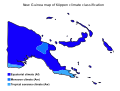 Image 1Papua New Guinea map of Köppen climate classification (from New Guinea)
 Image 2Papuan lake dwellings with a lakatoi under sail, 1898 or before (from History of Papua New Guinea)
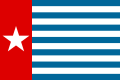 Image 3The Morning Star, flag of West Papua, was designed by the New Guinea Council in 1961. Its display is prohibited in some circumstances in Indonesia. (from History of Western New Guinea)
 Image 4Political divisions of New Guinea (2006) (from New Guinea)
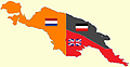 Image 6New Guinea from 1884 to 1919. The Netherlands controlled the western half of New Guinea, Germany the north-eastern part, and Britain the south-eastern part. (from New Guinea)
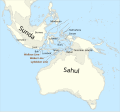 Image 7Map showing the combined landmass of Sahul formed during Pleistocene glacations (from New Guinea)
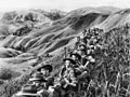 Image 8Australian soldiers resting in the Finisterre Ranges of New Guinea while en route to the front line (from New Guinea)
 Image 9Yali Mabel, Kurulu Village War Chief at Baliem Valley (from New Guinea)
 Image 11New Guinea Volunteer Rifles with captured Japanese flag, 1942 (from History of Papua New Guinea)
 Image 12Highlands of Papua New Guinea (from New Guinea)
 Image 13Map of New Guinea, with place names as used in English in the 1940s (from New Guinea)


 Image 17Papuans on the Lorentz River, photographed during the third South New Guinea expedition in 1912–13 (from New Guinea)
 Image 18Regions of Oceania: Australasia, Polynesia, Micronesia, and Melanesia. Australasia include the Australian landmass (including Tasmania), New Zealand, and New Guinea. (from History of Papua New Guinea)
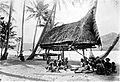 Image 19Group of natives at Mairy Pass. Mainland of British New Guinea in 1885. (from New Guinea)
- Image 22The continent of Sahul before the rising ocean sundered Australia and New Guinea after the last ice age (from New Guinea)
 Image 23A typical map from the Golden Age of Netherlandish cartography. Australasia during the Golden Age of Dutch exploration and discovery (ca. 1590s–1720s): including Nova Guinea (New Guinea), Nova Hollandia (mainland Australia), Van Diemen's Land (Tasmania), and Nova Zeelandia (New Zealand). (from History of Papua New Guinea)
- Image 25A 1644 map of New Guinea and the surrounding area (from New Guinea)
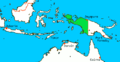
 Image 27Dutch expeditions in Netherlands New Guinea 1907–1915. (from History of Western New Guinea)
 Image 28Topographical map of New Guinea (from New Guinea)
- Image 29Regions of Oceania: Australasia, Polynesia, Micronesia, and Melanesia. Physiographically, Australasia includes the Australian landmass (including Tasmania), New Zealand, and New Guinea (from New Guinea)
 Image 30British flag raised in Queensland 1883 (from History of Papua New Guinea)
 Image 32Flag under German control of New Guinea. (from History of Papua New Guinea)
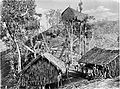
 Image 34A Japanese military map of New Guinea from 1943 (from New Guinea)
 Image 35An Australian soldier, Private George "Dick" Whittington, is aided by Papuan orderly Raphael Oimbari, near Buna on 25 December 1942. (from History of Papua New Guinea)
 Image 36Australian troops at Milne Bay, Papua.The Australian garrison was the first to inflict defeat on the Imperial Japanese Army during World War II at the Battle of Milne Bay of Aug–Sep 1942. (from History of Papua New Guinea)


.png)


.jpg)
.jpg)

.svg)


Related portals
WikiProjects
General topics
Categories

Associated Wikimedia
The following Wikimedia Foundation sister projects provide more on this subject:
-
 Commons
Free media repository -
 Wikibooks
Free textbooks and manuals -
 Wikidata
Free knowledge base -
 Wikinews
Free-content news -
 Wikiquote
Collection of quotations -
 Wikisource
Free-content library -
 Wikiversity
Free learning tools -
 Wiktionary
Dictionary and thesaurus
External media


