Idaho Falls Regional Airport
Airport serving Idaho Falls, Idaho / From Wikipedia, the free encyclopedia
Idaho Falls Regional Airport (IATA: IDA, ICAO: KIDA, FAA LID: IDA) is two miles north-northwest of downtown Idaho Falls, Idaho, United States.[1] It is locally known as Fanning Field.[2] It is the second-busiest airport in Idaho after Boise Airport.
This article has an unclear citation style. (October 2021) |
The National Plan of Integrated Airport Systems for 2011–2015 categorized it as a primary commercial service facility. Federal Aviation Administration records say the airport had 148,584 passenger boardings (enplanements) in calendar year 2008, 138,957 in 2009 and 144,365 in 2010.
Quick Facts Idaho Falls Regional Airport Fanning Field, Summary ...
Idaho Falls Regional Airport Fanning Field | |||||||||||||||
|---|---|---|---|---|---|---|---|---|---|---|---|---|---|---|---|
| Summary | |||||||||||||||
| Airport type | Public | ||||||||||||||
| Owner/Operator | City of Idaho Falls | ||||||||||||||
| Serves | Idaho Falls, Idaho | ||||||||||||||
| Location | 2140 N. Skyline Dr. | ||||||||||||||
| Elevation AMSL | 4,744 ft / 1,446 m | ||||||||||||||
| Coordinates | 43°30′49″N 112°04′15″W | ||||||||||||||
| Website | Official website | ||||||||||||||
| Maps | |||||||||||||||
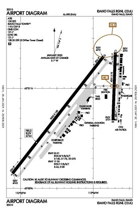 FAA airport diagram as of January 2021 | |||||||||||||||
 IDA  IDA | |||||||||||||||
| Runways | |||||||||||||||
| |||||||||||||||
| Statistics (2016) | |||||||||||||||
| |||||||||||||||
Idaho Falls Airport Historic District | |||||||||||||||
 The 1936 hangar in 2023 | |||||||||||||||
| Location | 2381 Foote Dr., Idaho Falls, Idaho | ||||||||||||||
| Coordinates | 43°31′02″N 112°03′30″W | ||||||||||||||
| Area | 4 acres (1.6 ha) | ||||||||||||||
| Built | 1930 | ||||||||||||||
| Architect | C.R. Black | ||||||||||||||
| Architectural style | Rustic | ||||||||||||||
| NRHP reference No. | 97001126[3] | ||||||||||||||
| Added to NRHP | September 10, 1997 | ||||||||||||||
Close