File:MapaMacau1912.jpg
From Wikipedia, the free encyclopedia
Size of this preview: 416 × 599 pixels. Other resolutions: 167 × 240 pixels | 631 × 908 pixels.
Original file (631 × 908 pixels, file size: 81 KB, MIME type: image/jpeg)
| This is a file from the Wikimedia Commons. Information from its description page there is shown below. Commons is a freely licensed media file repository. You can help. |
Summary
| DescriptionMapaMacau1912.jpg |
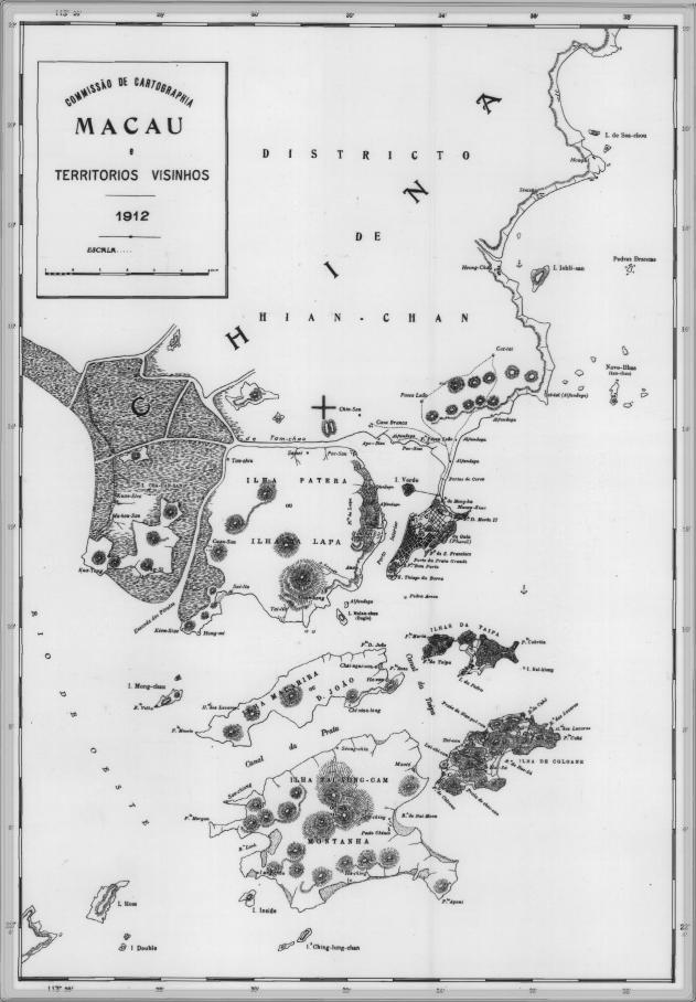
English: This is a map of Macau and is surrounded territories in 1912. In that time, the Portuguese Colony of Macau is formed by the Peninsula de Macau, Taipa and Coloane islands. Macau also have a great influence on the islands of Lapa, D. João and Montanha, located on the west of the Portuguese Colony of Macau. See here for original color version. |
| Date | |
| Source |
This file is lacking source information.
Please edit this file's description and provide a source. |
| Author |
This file is lacking author information.
|
Licensing
| Public domainPublic domainfalsefalse |
This work is from an official work of Macau and is in the public domain in Macau and possibly other jurisdictions. See here for the type of material that are in the Public domain in Chinese and Portuguese (official languages of Macau), plus English (not an official language of Macau).
|
 | |
| English ∙ español ∙ 日本語 ∙ 한국어 ∙ македонски ∙ português ∙ português do Brasil ∙ ไทย ∙ 中文(简体) ∙ 中文(繁體) ∙ +/− |
| Annotations InfoField | This image is annotated: View the annotations at Commons |
314
361
29
23
631
908
Chin-san [Qianshan]
328
377
21
20
631
908
Casa Branca [Residence & office of the subprefect with jurisdiction over Macao]
Captions
Add a one-line explanation of what this file represents
Items portrayed in this file
depicts
1912
File history
Click on a date/time to view the file as it appeared at that time.
| Date/Time | Thumbnail | Dimensions | User | Comment | |
|---|---|---|---|---|---|
| current | 09:34, 14 February 2007 | | 631 × 908 (81 KB) | AdriAg | This is a map of Macau and is surrounded territories in 1912. In that time, the Portuguese Colony of Macau is formed by the [http://pt.wikipedia.org/wiki/Pen%C3%ADnsula_de_Macau Peninsula de Macau], [http://pt.wikipedia.org/wiki/Taipa Taipa] and [http://p |
File usage
The following pages on the English Wikipedia use this file (pages on other projects are not listed):
Global file usage
The following other wikis use this file:
- Usage on es.wikipedia.org
- Usage on fa.wikipedia.org
- Usage on fr.wikipedia.org
- Usage on it.wikipedia.org
- Usage on ja.wikipedia.org
- Usage on mwl.wikipedia.org
- Usage on nl.wikipedia.org
- Usage on no.wikipedia.org
- Usage on pt.wikipedia.org
- Usage on ru.wikipedia.org
- Usage on ur.wikipedia.org
- Usage on zh.wikipedia.org
Metadata
This file contains additional information, probably added from the digital camera or scanner used to create or digitize it.
If the file has been modified from its original state, some details may not fully reflect the modified file.
| _error | 0 |
|---|
Retrieved from "https://en.wikipedia.org/wiki/File:MapaMacau1912.jpg"