File:Zhujiangrivermap.png
From Wikipedia, the free encyclopedia
Size of this preview: 800 × 542 pixels. Other resolutions: 320 × 217 pixels | 640 × 433 pixels | 988 × 669 pixels.
Original file (988 × 669 pixels, file size: 308 KB, MIME type: image/png)
| This is a file from the Wikimedia Commons. Information from its description page there is shown below. Commons is a freely licensed media file repository. You can help. |
Summary
| DescriptionZhujiangrivermap.png |
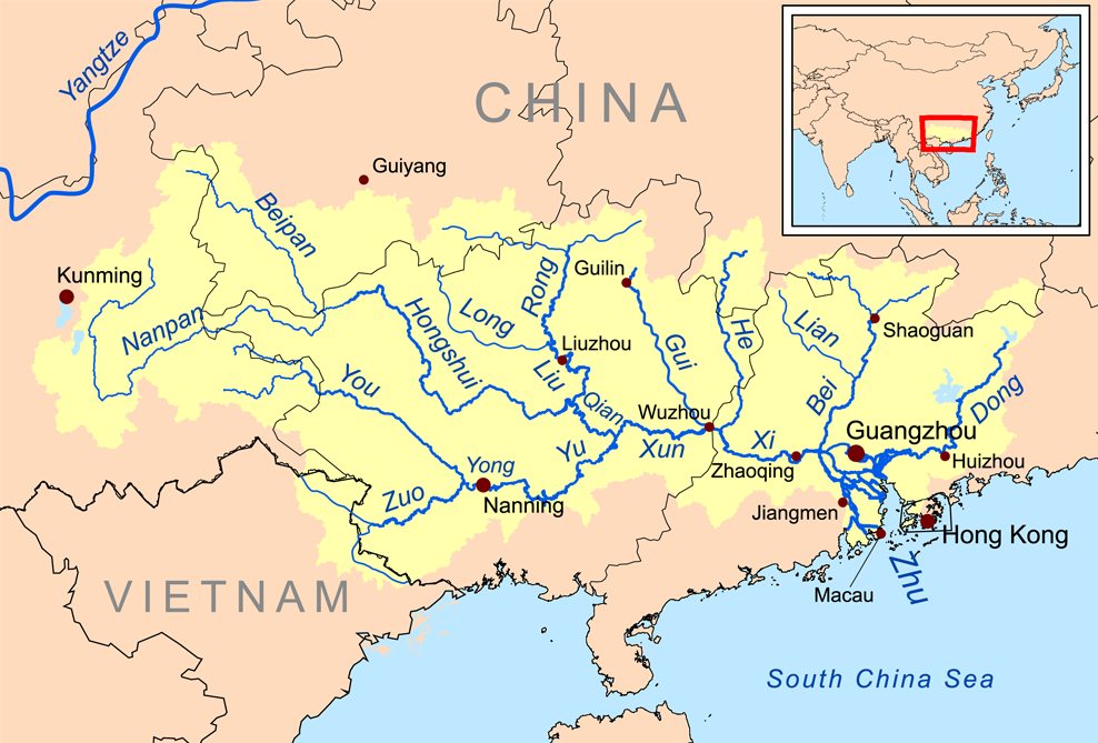
English: Map of the tributaries of the Pearl River, and the Pearl River Basin (watershed/drainage basin) in yellow.
|
| Date | |
| Source | Own work |
| Author | Kmusser |
| Other versions | Estonian |
Licensing
I, the copyright holder of this work, hereby publish it under the following license:
This file is licensed under the Creative Commons Attribution-Share Alike 3.0 Unported license.
- You are free:
- to share – to copy, distribute and transmit the work
- to remix – to adapt the work
- Under the following conditions:
- attribution – You must give appropriate credit, provide a link to the license, and indicate if changes were made. You may do so in any reasonable manner, but not in any way that suggests the licensor endorses you or your use.
- share alike – If you remix, transform, or build upon the material, you must distribute your contributions under the same or compatible license as the original.
Captions
Pearl River is shown here by its Chinese name Zhu (from Mandarin pinyin Zhujiang: "Pearl River"); it is known also by older romanization Chu Kiang, and was known often as the river Canton. Shown also are rivers Xi (West), Bei (North) & Dong (East).
Items portrayed in this file
depicts
19 November 2008
File history
Click on a date/time to view the file as it appeared at that time.
| Date/Time | Thumbnail | Dimensions | User | Comment | |
|---|---|---|---|---|---|
| current | 13:59, 21 December 2015 | | 988 × 669 (308 KB) | Ras67 | cropped |
| 20:09, 19 November 2008 |  | 1,000 × 681 (346 KB) | Kmusser | {{Information |Description=This is a map of the Pearl River drainage basin. |Source=Own work using http://www.maproom.psu.edu/dcw/ Digital Chart of the World and [[http://edc.usgs.gov/products/elevation/gtopo30/gtopo30.html |
File usage
The following pages on the English Wikipedia use this file (pages on other projects are not listed):
- Baise Uprising
- Bei River
- Beipan River
- Dong River (China)
- Flooding of the Pearl River
- Geology of the Pearl River Delta
- Gui River
- Hongshui River
- List of rivers of China
- Liu River
- Liuzhou
- Long River (Guangxi)
- Nanpan River
- Pearl River
- Qian River
- Rong River (Guangxi)
- Xi River
- Xun River
- Yong River (Guangxi)
- You River (Guangxi)
- Yu River (Guangxi)
- Zhuang people
- Zuo River
- User:Kmusser/Images
- User:Mcasey666
- User:Oooliviawaw/sandbox
Global file usage
The following other wikis use this file:
- Usage on af.wikipedia.org
- Usage on ar.wikipedia.org
- Usage on arz.wikipedia.org
- Usage on ast.wikipedia.org
- Usage on azb.wikipedia.org
- Usage on az.wikipedia.org
- Usage on ba.wikipedia.org
- Usage on be.wikipedia.org
- Usage on bg.wikipedia.org
- Usage on bh.wikipedia.org
- Usage on bn.wikipedia.org
- Usage on ceb.wikipedia.org
- Usage on cs.wikipedia.org
- Usage on da.wikipedia.org
- Usage on de.wikipedia.org
- Usage on eo.wikipedia.org
- Usage on es.wikipedia.org
View more global usage of this file.
Metadata
This file contains additional information, probably added from the digital camera or scanner used to create or digitize it.
If the file has been modified from its original state, some details may not fully reflect the modified file.
| Horizontal resolution | 28.35 dpc |
|---|---|
| Vertical resolution | 28.35 dpc |
Retrieved from "https://en.wikipedia.org/wiki/File:Zhujiangrivermap.png"